Human settlements in general and urban centers in particular have more often than not betrayed the planner’s perception of their growth and developmental processes. Chandigarh is no exception to this general rule of human limitation. There always emerges a gap between what is visualized and what actually comes up i.e. between vision and reality, because city growth and development is largely guided by the economic forces and these critical forces are highly unpredictable and dynamic in nature. Moreover, there is a distinct time gap between planning and development and this gap invariably leads to new realities emerging on the city scenario. Human behaviour and their needs are very complex which makes the planning process highly vulnerable. Fast changing technologies, and means of transport and communication have added more uncertainties to the already hazy future and accordingly have made city planning very complex.
Emergence of large number of contradictions on city horizon poses new challenges to city planners in evolving appropriate plans, which minimize these contradictions and frictions. The Chandigarh of today poses this very dilemma to planners and experts to evolve appropriate strategies and framework for action, which will enable this city to grow in an orderly manner and maintain its distinct character, which planners conceived for this city beautiful. Search for appropriate solutions has assumed importance because the city is in crisis and in danger of fast losing its special identify.
PLANNING
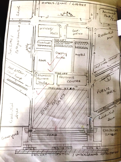
Planned on a rigid, rectangular grid iron pattern of roads, half a mile apart in the east-west direction and three-quarters of a mile in the north-south direction, the Chandigarh plan promised basic amenities of life even to the poorest of the poor of its citizens to lead a dignified life. Safe from fast traffic, in easy reach of all needs of material, mental and moral sustenance and growth, surrounded by nature in an intimate community and yet part of a real city, this was the life dreamed of for the 5 lakh inhabitants to be brought into the city in two distinct phases of development. A distinct quality of life was accordingly assured to a distinct class of people to be housed in this capital city to be established on a terrain with great mountains to the north, and two rivers flowing approximately 7-8 kms. apart. The human life in the city was proposed to be compartmentalized and put into air-tight containers of working, living, care of body and spirit, known as SECTORS, each having human contents varying between 5,000 & 25,000, separated by fast moving traffic arteries known as V2 and V3 and connected with a certral green flowing from south to north in the direction of great mountains.
The Master Plan of the city re-drawn by Le-Corbusier in four hectic days of inspired activity in February 1951, was largely based on the well-advanced master plan prepared by Albert Mayer. It changed the shape of the city from a leaf to a rectangle, reducing considerably the size of the city in the process. The basic unit of planning was changed from a super-block to sector based on the same neighbourhood concept i.e. city within a city. The sector constituted an attempt to create space, which provided for day-to-day material and social needs of the citizens in easy reach of home, but at the same time linked to a larger scale of the city in terms of transport and services. The entire network of sectors was woven with a so called efficient system of traffic and transportation governed by the rule of 7 Vs changed by adding V8 to suit the specific needs of the city. Sector planning was made introvert with no door opening on to V2 & V3. The focus of life within the sector was V4 – the shopping street -which was to contain amenities needed for catering to the material needs of the residents. The size and shape of the sector was based on considerations with focus on human beings and their welfare. The industrial area was placed on the south-east of the city to eliminate any possibility of heavy traffic entering the city. A 500 feet wide green belt provided an organic green to seal the residential sectors from industrial fumes and noise. Educational area occupied the north-west side with work centers concentrated in the Capitol Complex, City Centre, Sub-city Centre and along the major axis.
The Master Plan envisaged a distinct density pattern with density level much higher in the second phase as compared to the first phase. An effective mechanism of controlling and safeguarding the space around the new city from the onslaught of haphazard growth and development was provided by declaring an area of 5 miles which was subsequently increased to 10 miles as periphery area. Tree preservation order and advertisement control order were issued to protect trees and to regulate the display area. These in nut-shell were the planning and protective mechanisms evolved to safeguard the quality of life in the city of tomorrow’s India.
PROBLEMS AND PROSPECTS
During the short span of 45 years of its existence, Chandigarh has the distinction of achieving number of mile-stones which range from achieving substantial degree of growth and development as per the provisions of the Master Plan, achieving its projected and targeted population of 5 lakh, making provisions of a sufficiently high order of amenities and services, ensuring much better quality of life to the residents, setting high norms and standards of planning and development, creating awareness about the importance of planned growth and to prove good urbanism makes good money. These mile-stones have been achieved despite tremendous population and developmental pressures which the city was able to cope effectively and efficiently in the face of unforeseen developments emerging out of changes in geo-political situation of the region in 1966. the city in the recent past has started showing signs of enormous stress due to ever increasing population pressure, rapidly transforming urban form, fast changing class-structure and ever increasing unplanned and unforeseen physical and economical activities. There is an urgent need of quantifying these stresses and suggesting appropriate strategies to minimize them.
One of the major problems facing the city is the enormous population growth both of the city and that of the adjoining areas. There is also rapid increase in the floating population, which come to work, and avail of the services in the city. The sum total of all this has already exceeded the planned population. In fact it is this increase in human numbers, which is causing anxiety to planners and administrators. Distribution of population within the city has not been orderly. Few sectors have become over crowded whereas in few others the density is very low. Sector 20 has the highest population of 26,079 persons whereas Sector 9 has a population of only 2,613 persons. These population differences are basically due to the planning of these sectors arising on account of larger and smaller sized plots provided therein. In fact, the entire city can be stratified in different zones of high density and low density with density increasing as we go toward the south. The southern most sectors have been planned with highest density. Unfortunately in Chandigarh, no attempt was ever made to distribute the planned population all over the city and sector planning was thus an exercise merely to carve out first bigger plots then reducing the size of plots and now providing flats without considering its impact on the quality of life and social fabric of the city. By virtue of the planning process adopted, the city has a social stratification, which clearly defines areas of different quality of life. The new kind of planning which is being undertaken in sectors 48 & 49 (for co-operative societies) is going to create enormous population pressure on the city services. In these sectors, areas under green spaces have been drastically cut down whereas number of dwelling units have been increased tremendously. All this calls for looking at the entire planning mechanism of the city if it is to be saved from further stratification. The city now needs to be planned rather than designed with planning not made subjective but governed by latest innovations. A group of experts may be assigned to undertake the job. Creation of an effective system for planning and monitoring the city growth would help in promoting orderly growth of the city. City is now ripe for the study to be undertaken for stage three i.e. Re-densification of Stage-One, which was suggested by Le-Corbusier to absorb the future growth of population of the city.
Root cause of Chandigarh’s problems has been that Chandigarh planning and development has been seen in isolation compared to the development of its periphery and region. In fact what happens in Panchkula, and Mohali is bound to affect Chandigarh. Any population pressure in Mohali and Panchkula will in turn pressurize the city services and road network and unless and until a coordinated approach for planning and development of Chandigarh. Mohali, Panchkula, Mani-Majra and Chandi-Mandir is adopted rational growth of the city cannot be ensured. The Creation of High Powered Committee of two states and U.T., which should take all vital decisions of growth and development of these cities is absolutely essential. A co-ordinated and mutually supportive approach would be a pre-requisite for ensuring orderly growth in the region. Punjab and Haryana should be asked to develop office complexes and create housing for their employees in Mohali and Panchkula and shift their directorate and other non-essential offices to those areas. Further the level of educational and other services to be created in Mohali and Panchkula should be brought at par with that of Chandigarh so as to reduce pressure on Chandigarh. More investment must flow to Panchkula and Mohali for ensuring their optimum growth.
Traffic problems within the city area have to be viewed in the context of city planning. The city plan conceives zoning the city into distinct areas earmarked for living, working and leisure and accordingly one would have to travel for going to place of residence or to go for leisure etc. Thus travel is inherent in the city plan. Unfortunately this travel component assumes complex proportions with the growth of the city and accordingly people are subjected to long and unnecessary travel. This leads to congestion and pollution besides making the city highly energy inefficient. In order to minimize travel in the city area, it would be desirable to decentralize work centers and provide basic amenities at the local level of an appropriate order. Mixed zoning needs to be adopted to reduce distances between different components of human activities if the city is to be saved from traffic chaos of the future.
Besides taking care of the intra-city traffic by rationalizing the land use pattern within the city, it would be crucial to effectively manage the inter-city traffic also. This would require the city to be seen in the larger context i.e. region. The present alignment of NH-21 passes through the most crowded part of the city is creating large number of problems by allowing through traffic to flow within the city. In order to take care of the inter-city traffic, following suggestions are made:
a) All missing links between Chandigarh and Mohali should be completed immediately to ensure dispersal of traffic.
b) Additional linkages with Panchkula should be created so as to ensure smooth flow of traffic between these two areas and also to reduce pressure on Madhya Marg. If this is not done the city would be in crisis.
c) New link from Kurali should be created via Siswan-Mulanpur to Baddi (H.P.) area so as to divert entire traffic meant for Himachal Pradesh.
d) Present alignment of bye-pass of NH-21 passing through the city should be immediately changed and shifted out of the city. The present bye-pass should be realigned to take off from Ghaggar. It should also bye-pass Zirakpur, Mohali and Kharar to meet the Chandigarh-Ludhiana and Chandigarh-Ropar-Mandi road to cater to the needs of the traffic meant for Patiala, Ludhiana, Ropar, Hoshiarpur and H.P.
e) The existing Ambala-Banur-Landran-Kharar road needs to be strengthened and upgraded to take care of all the traffic coming from Delhi and going towards Ropar, Hoshiarpur, Mandi etc.
Chandigarh promised basic amenities of life even to the poorest of the poor to lead a dignified life but as the things stand today 9.08% of its population lives in slums. Thus every eleventh man in the city leads an undignified life. Recent survey conducted by the Estate office shows an estimated 19,210 jhuggies, which exist in Chandigarh. Growth of the slums has been phenomenal in the past despite the recent programme undertaken by the Administration to slums dwellers on a large scale. The experience of all other cities in the country including Delhi is not different on this account. What needs to be seen is who are the people who come to this city and squat on the government land. There is an urgent need to check this cancerous growth before it may adversely affect the quality of life in the city. Rehabilitation of slums within the city area as has been done in case of Sector 56 in Palsora would be disastrous (3800 units in 50 acres) and needs an immediate review. Solving this problem would require both preventive and curative measures. Strict enforcement against encroachment, provision of land for low income group within the sectors, review of allotment and rehabilitation policy and checking connivance of officials in the growth of slums are the few factors which can lead to appropriate solutions. If the city is threatened by residential slums, growth of commercial slums have also gone unabated. Uncontrolled growth of Rehri Markets in each sector has eaten away vital green spaces provided at the sector level and created numerous problems. Present policy of appeasement and providing constructed booths on ownership basis have given further impetus to the mushrooming growth of these unauthorized markets. Factors like land disposal policy of auction adopted for commercial sites, lack of commercial space at local level, concentration of shopping in the shopping street and lack of small shops are some reasons for the growth of these commercial slums. In order to tackle this menace it would be desirable to earmark larger areas under commercial use, create larger number of commercial sites, increase proportion of booths considerably, disperse commercial area in different corners of the sector, provide space for day markets at sector level and review the land disposal policy of commercial sites.
If the city is threatened by residential slums, growth of commercial slums have also gone unabated. Uncontrolled growth of Rehri Markets in each sector has eaten away vital green spaces provided at the sector level and created numerous problems. Present policy of appeasement and providing constructed booths on ownership basis have given further impetus to the mushrooming growth of these unauthorized markets. Factors like land disposal policy of auction adopted for commercial sites, lack of commercial space at local level, concentration of shopping in the shopping street and lack of small shops are some reasons for the growth of these commercial slums. In order to tackle this menace it would be desirable to earmark larger areas under commercial use, create larger number of commercial sites, increase proportion of booths considerably, disperse commercial area in different corners of the sector, provide space for day markets at sector level and review the land disposal policy of commercial sites.
Another ever growing problem which should cause considerable anxiety and concern to the custodians of the city is the uncontrolled, unchecked, unhindered and unregulated development and growth of 4 villages which fall within the planned sectors of the city. These four villages have a combined population of 27,025 (1991) with Burail alone recording a population of 16,000. It is unfortunate that a decision was taken to retain these villages and allow their unplanned growth. A look at these villages shows the quality of life available and how mushroom growth is taking place there. In the absence of appropriate and basic amenities these villages have become a source of nuisance to the adjoining planned area. It is high time that development within these villages and conversion of land use in them is effectively managed and regulated otherwise these villages would ultimately become hot beds of speculation and would have commercial development of substandard nature which may adversely affect the safety of the area. These villages need to be properly planned and developed and provided with basic amenities for effective integration with nearby residential areas. Decision to retain/acquire other villages falling in future sectors should be taken in the light of experience gained in other cities.
Provision of green spaces in the sector were basically meant to provide lungs to the area and for developing areas of leisure. But as it stands today green spaces have become largely eye-sores. In fact maintenance and upkeep of green spaces is very expensive and needs constant care and upkeep. In the initial planning, sectors were provided with large green spaces, which were subsequently reduced considerably. However no norms and standards for open spaces have been evolved for sector planning so far. In order to effectively manage and protect the open spaces it would be desirable to involve the community who should be made custodians of such open spaces, to protect and safeguard it against any possible misuse, conversion and encroachment. Carving out Institutional sites out of green spaces needs to be avoided and its conversion for residential or commercial use should be prohibited. However, proper norms and standard for green spaces, their size, shape and location in the residential area keeping in view their optimum utilization should be worked out and incorporated in the future planning.
In recent times, cult of encroachment, conversion of land uses and unauthorized construction has gained considerable momentum. The areas ripe for such misuse are largely the houses developed by Chandigarh Housing Board. This needs to be checked. Construction and development by Housing Board must be brought under effective control so as to ensure their effective merger with other surrounding areas. Housing Boards must not exercise any control on the development of the area, which should vest with the Estate Office. The designs and layout plans evolved by Housing Board also need closer scrutiny so as to minimize the elements of misuse. Housing Board should not be allotted land abutting the sector roads or along shopping streets or major arteries so as to minimize their misuse. Allowing resumption of houses where misuse occurs should be only after corrective measure are taken or punishing the owners of such houses should be effectively resorted to, to minimize misuse.
Corbusiers novel idea of making Chandigarh a unique city with regard to providing food to the city population on a co-operative basis still remains confined to papers only. If this idea was realized many fruit and vegetable make shift shops would not have existed and city would have looked much cleaner than what it looks now. It would have saved not only administration from the Rehri menace but would have benefited the inhabitants of Chandigarh immensely.
Another critical area which has emerged in the context of development of Chandigarh is its periphery which was initially meant to provide all basic and day to day needs of the new city. However, after re-organization of state of Punjab in 1966, when Chandigarh became Union Territory (a centrally administered unit) with capital of two states of Punjab and Haryana and its periphery area got divided into three parts with majority of share going to state of Punjab and Haryana. The sanctity of periphery was violated with impunity with large scale unauthorized constructions coming up within the periphery. The extent of magnitude of unauthorized constructions can be gauzed from the fact that during last 30 years more than 15,000 such violations have been detected in the state of Punjab alone. Situation in Haryana and Chandigarh is no better. The uncontrolled, haphazard, unauthorized, sub-standard developments in peripheral area has created enormous pressure on city infrastructures and has also adversely affected quality of life in and around the beautiful city of Chandigarh.
After re-organization of state of Punjab and tri-furcation of periphery, Punjab established new township of SAS Nagar with a planned population of 2.5 lakh and Panchkula was established by Haryana in close vicinity of Chandigarh for a population of 1.5 lac within the periphery area. Both these towns have already achieved a population of one lac each and because of lot of developmental pressures they are being expanded continuously by adding more and more areas. The original concept of Corbusier to contain the city growth to 47 sectors has already been violated and number of sectors have already gone up to 81 (almost double the number originally planned for). SAS Nagar is fast emerging as an industrial town with more than 1200 hectare going for both medium and heavy industries. As such the total character of Chandigarh and its surrounding areas is undergoing drastic changes with a large urban agglomeration emerging on the otherwise placid area meant for agriculture etc. Because of paucity of basic infrastructures in the new towns of SAS Nagar and Panchkula (which are in the process of development) the pressure on infrastructures in Chandigarh is growing large and large. Deficiency in delivery of urban services and its mismanagement are becoming obvious. In the absence of any co-ordinated approach to the planned development by three state administrations, growth and development of Chandigarh, SAS Nagar and Panchkula is becoming lopsided.
LESSONS
Chandigarh despite numerous problems and adversities convey number of messages and offers lessons to the planner, architect, engineers and administrators in the context of planning, development and management of urban settlements so as to enable such settlements to achieve the goal of optimum human welfare besides providing a certain quality of life to its residents. These messages could be summed up as under: –
(1) No city is finite, therefore, it would be wrong on the part of planners to assume and plan for a Finite City. A city must be planned to cater to any unforeseen growth and development and must be able to absorb any shock caused by developmental forces. It must be planned on a module, which leads to an inbuilt system of flexibility in the planning process without adversely affecting the basic fabric of the city.
(2) It is easy to think of a small city with a population of 5 lacs with a ten miles periphery of green belt for keeping the city supplied with essential nutrients. But in practice it does not work. The real challenge is to evolve a city system which can expand and yet maintain a green edge which keeps the city supplied with food and keeps the nature close by.
(3) Compartmentalization of human activities should invariably be avoided. This leads to increased travel needs resulting in wastage of time and resources besides causing enormous travel stress on human beings. Planning for the entire gamut of human activities considering them as an ‘integrated whole’ would be very vital for creating cities which are highly energy efficient by considerably reducing the travel needs of the people. Mechanism of mixed zoning instead of rigid zoning needs study and application in the siting and location of different uses and functions in the city to minimize traffic requirements.
(4) Inter and intra-city traffic must be planned on different footings. The two must not be allowed to mix in order to avoid chaos in traffic in the city area.
(5) Planning, development and management of a city cannot be viewed in isolation. It has to be viewed in the larger i.e. regional context. Planning of city and region must be done in an integrated manner. A common authority for city and region would be a pre-requisite to ensure optimum growth of city and its region.
(6) Research and Development must be made an integral part of all planning, development and management processes. Permanent R & D machinery must be set up to ensure orderly planning and development of any city. This would help in eliminating many pitfalls, which are caused due to decisions based on subjectivity and lack of information.
(7) Rigid developmental controls always lead to stagnation and violations. Controls must be reviewed periodically and updated to keep pace with changing needs and aspirations of the people and society so as to achieve the desired objective of orderly growth and development.
(8) Short-term city development plans should be prepared for proper growth. Long term perspective plans have led to stagnation of planning and developmental efforts in the face of rapidly changing needs and technologies.
(9) A committed and dedicated team of experts considerably helps in ensuring planned development of any settlement and is a pre-requisite if continuity of planned growth is to be ensured. Higher planning input is of paramount importance for promoting planned growth of the city.
(10) Planning and development of a new city should not be handled by a single person but should be made a collective effort of a group of experts in order to eliminate elements of subjectivity and to ensure continuity of thought and action.
(11) A unified planning, development and management machinery/ agency always helps in promoting orderly growth of the city and to ensure provision of basic amenities and services.
(12) Large scale acquisition of land in the initial stages of the project always helps in smooth planning and development of the city. It also helps in generating vital financial resources for city development maintenance, upkeep and provision of higher order of basic amenities, services and infrastructure.
(13) The city must make provision for the service sector of the city, which is vital for the maintenance and upkeep of the city services. Ignoring this sector invariably leads to unauthorized construction, encroachment and growth of slums etc.
(14) No city has one finite plan. It is the product of series of plans which are evolved over a period of time to take care of changing realities and dynamism of urban settlements. Any stagnation of planning effort or rigidity in approach leads invariably to lopsided development of new cities.
Source:
An Article by AJIT KUMAR GUPTA
CHIEF TOWN PLANNER at Sahara Prime City

 Perhaps, city planning can’t be implemented in the current city, though, to some extent some planners tries to implement their ideas or plan. Somewhere it works a little bit but mostly this plans face failure. Because one can not fully alter the whole pattern of a city.