The distribution of farmstead, newly created hamlets and refugee camps the best layout of roads , location of service centres, construction of houses for poor and planning of buildings are the problems, which could be solved by the coordinated and cooperative efforts of Geographers , Sociologists and Planners.
The settlement geographers can suggest the alterations in the pattern of roads and the distribution of services, that can make the transformation least painful. One may study settlement planning in following heads:
Planning , in relation to locational efficiency of land-use, marketing, living conditions etc.
in relation to current economic well-being and social dynamics and demands of modernisation
the service villages and rural service centres as agents of rural change
the infrastructural development for rural uplift including planning
Before making a plan, one must look rural settlements as social units, to look into their social dynamics, rural urban relationship and change stages between traditional society and advance urban systems.
Ecological Basis of Planning
it is needless to emphasise that, how far ecological processes are dealt with, has now become a criterion of social progress and an index of civilization’s level of culture. here comes geographical research with its great potential for a holistic approach to study the natural and social phenomenon. main trends of ecological research or inquiries in geography can be defined as:
control over changes in the environment caused by human activity
scientific, geographic forecast of the consequences of the increased economic activity
prevention, mitigation and elimination of calamities
optimization of the environment in the natural technical systems created by man
Planning Service Villages and Rural Service Centres
A three tier system arrangement is evident in the hierarchy of settlements i.e. a dependent village at lower level, central village at higher level and service village at higher level and service centre on the top. A more or less hexagonal pattern will emerge around such service centres. having fixed locational priorities. these emerging centres would fit in, both the traditional as well as well as emerging spatio- temporal frame. As India’s population is on the threshold of an agricultural, non-agricultural and rural- urban continuum, these centres would emerge to take their due position in the locational hierarchy , of population centres. Selection of such centres, however , is to be made continuously, impartially, unbiased and without having any prestige attachment, political or religious.
Settlement planning should follow a holistic approach. Planner should take into account many perspective like Rural Urban Continuum, Rural Urban Dichotomy, Garden City Concept and others. Rural- urban continuum is the merging of town and villages so it may complicate the planning process.The Planner will have to take into account the fast growth of slums specially in Asian Cities.
In multi level planning there is certain hierarchy of regions. We can classify it in many ways depending on chosen criterion/criteria. In India it has a long history.
Unified settlement planning (USP) is a component of regional planning where a unified approach is applied for a region’s overall development. The USP approach is most often associated with urban planning practices in India.
Regions use their land in for various usage, including agriculture, manufacturing, and public administration. For society to develop, it has to amalgamate and develop settlements; their coexistence is the basis for a holistic development of any society in conjunction with regional planning. The Urban sphere of influence is also taken in account.
Sir Ebenezer Howard is known for his publication Garden Cities of To-morrow (1898), the description of a Utopian city in which people live harmoniously together with nature, which forms the basis for unified settlement planning. The publication resulted in the founding of the garden city movement, that realized several Garden Cities in Great Britain at the beginning of the 20th century.
Walter Christaller (April 21, 1893 – March 9, 1969) who was a German geographer, developed the idea of Central Place Theory. It stated that settlements simply functioned as ‘central places’ providing services to surrounding areas.
August Lösch , a German economist, is regarded as the founder of Regional Science. August Lösch expanded on Christaller’s work in his book ‘The Spatial Organization of the Economy'(1940). Unlike Christaller, whose system of central places began with the highest-order, Lösch began with a system of lowest-order (self-sufficient) farms, which were regularly distributed in a triangular-hexagonal pattern. He thought that Christaller’s model led to patterns where the distribution of goods and the accumulation of profits were based entirely on location. He instead focused on maximizing consumer welfare and creating an ideal consumer landscape where the need to travel for any good was minimized and profits were held level, not maximized to accrue extra.
Gandhiji visioned for a free country governed by their own people;he penned down his visions in a book Hind Swaraj or Indian Home Rule in 1909. Swaraj stated that every village should be its own republic, “independent of its neighbours for its own vital wants and yet interdependent for many others in which dependence is necessary”. A decentralized, unexploited, co-operative, self-reliant and peace-loving development of a region is must for development of India
These ideas of swaraj was developed in light of contemporary scenario in India as Providing Urban Amenities to Rural Areas (PURA), envisioned by former president of India and an eminent scientist Dr A. P. J. Abdul Kalam and framed by Prof. Emerson.
PURA proposes that urban infrastructure and services be provided in rural hubs to create economic opportunities outside of cities. These ideas will be possible through physical connectivity by providing roads, electronic connectivity by providing communication network and knowledge connectivity by establishing professional and Technical institutions. The mentioned programs will have to be done in an integrated way so that economic connectivity will emanate. The Indian central government has been running pilot PURA programs in several states since 2004
The fundamental objective for a unified settlement plan includes
· Low cost of living with basic requirements.
· Ample work opportunities, near the residences .
· Viability of institutions along with ample options for the clientele.
· Efficiency of the infrastructure, without any prejudice to the density of the settlements.
· Fool-proof security, especially for the areas with large population concentration.
· Each region to be self-reliant and interdependent wherever necessary.
The strategies for achieving the objectives include:
· Definition of the regional modules.
· Minimizing the expenditure on land for urban amenities.
· Avoiding expenditure on the new residences for the population with existing houses.
· Development of efficient and economical transportation systems from origin to destination.
· Comparable generation and utilisation of energy in the module.
· Self-sufficiency in water utilisation .
· Cooperative ownership of the urban land and its key facilities.
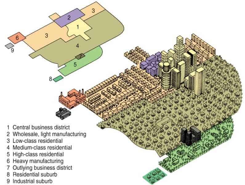
Multiple nuclei model of 1945 by C.D. Harris and Edward L. Ullman is based on the argument that the cities have multiple growth points or “nuclei” around which growth take place. This model was given in an article by them “The Nature of Cities.”
Concept and need for Multiple Nuclei Model
This model is based on the structure of Chicago just like the Burgess model or Concentric zone model of 1925. It can be considered as an attempt to explain the structure of the city taking into account the complexity and growth over time. Harris and Ullman argued that a city might start with a single central business district (CBD), but over the time the activities scatter and gets modified. The scattered activities attract people from surrounding areas and act as smaller nuclei in itself. These small nuclei gain importance and grow in size and start influencing the growth of activities around them.
Multiple nuclei model 3 dimensional view
The need for this model was to provide a more realistic explanation of the cities. The influence of cars on personal travel and greater movement of goods offered opportunity in different places instead of concentrating all economic activities in one place. People started optimizing their business for maximum profit by locating at a different place and bringing down their rent with a slight increase in transportation cost. Whereas some activities like industrial areas create pollution and are thus preferred to be located away from residential areas. This model is considered to be more suitable for cities which are large and expanding.
Video explaining the models for city development: Multiple Nuclei Model
Activities listed under the model
The activities listed in the model can be considered as independent zones which influences activities around them. These are also formed because of their dependence on one another when such activities are located in proximity a “nuclei” is said to be developed.
Central business district
Light manufacturing
Low-class residential
Middle-class residential
Upper-class residential
Heavy manufacturing
Outlying business district
Residential suburb
Industrial suburb
Assumptions for Multiple Nuclei Model
The land is not flat – This provides a more practical application of the multiple nuclei model and is an improvement over the Burgess model. It is difficult to find flat land for big cities, and the terrain features effects the activities, development, and direction of growth of an urban area.
Even distribution of resources – Resources are evenly distributed within the city, no one enjoys privileges or has exclusive access to resources.
Even distribution of people in Residential areas – People are distributed homogeneously and not concentrated in a particular area or pocket. This is essential as an unevenly distributed population has a direct impact on markets.
Even transportation cost – Transportation cost is even in the city and not influenced by location.
Profit maximization – A particular activity will locate itself where maximum profit can be earned. For this, a different combination of rent, transportation costs, labor cost, proximity to market may be tried, and the combination which yields the best result gives the final location for the activity. This location also takes into account the restrictions over the activity and the need to be separated from other noncompatible activities such as locating residential areas away from industrial, locating large industries with more accessibility to reduce transportation cost and to ease the movement of goods.
Multiple nuclei model
Limitations and criticism of the Harris & Ullman’s Multiple Nuclei Model
Multiple nuclei model was considered much better than the previous simple models which attempted to explain the structure of urban areas. However, this model also had its limitations and could not be applied to many cities and did not entirely explain the structure of urban areas. Formation of well-defined zones or “nuclei” required the considerable size of the city as the small or new towns do not have a very well defined location because of which they are usually scattered. Another drawback is the limited activities which are considered in the model along with the very rigid and specific boundaries of the activities. Some other disadvantages include:
Negligence of the height of buildings.
Non-existence of abrupt divisions between zones.
Each zone displays a significant degree of internal heterogeneity and not homogeneity.
Unawareness of inertia forces.
No consideration of the influence of physical relief and government policy.
The concepts may not apply to Asian cities with different cultural, economic and political backgrounds.
The huge size of the urban population, haphazard and unplanned growth of urban areas and a severe lack of infrastructure are the main causes of pathetic situation. The rapid growth of urban population both natural and through migration has put heavy pressure on public utilities like housing, sanitation, transport, water, electricity, health, education and so on.
Urban Sprawl:
Urban sprawl or unplanned expansion of the towns and cities, of rapidly growing cities is perhaps the cause of urban problems. In most cities, the economic base is incapable of dealing with the problems created by their excessive size. Massive immigration from rural areas as well as from small towns into big cities has taken place almost consistently; thereby adding to the size of cities.
Poverty, unemployment and under employment among the rural immigrants, beggary, thefts, dacoities, burglaries and other social evils are on rampage. Urban sprawl is resulting in the rapid loss of the precious fertile agricultural land.
The greatest pressure of the immigrating population has been felt in the central districts of the city (the old city) where the immigrants flock to their relatives and friends before they search for housing. Population densities beyond the “old city” decline sharply.
Brush (1968) has described this situation in the central parts of the cities as “urban impulsion” which results from concentration of people in the centre of the city close to their work and shopping. Incidentally many of the fastest growing urban centres are large cities.
This is due to the fact that such large cities act as magnets and attract a large number of immigrants by pull of employment opportunities and modern way of life. Such hyperurbanisation leads to projected cities sizes of which defy imagination. Delhi, Mumbai, Kolkata, Chennai, Bangalore, etc. are examples of urban sprawl due to large scale migration of people from the surrounding areas.
In many big cities wealthy people are constantly moving from the crowded centres of the cities to the more pleasant suburbs where they can build larger houses and enjoy the space and privacy of a garden around the house. In some cities, the outskirts are also added to by squatters who build makeshift shacks of unused land although they have no legal right to the land. The difficulty of restricting town growth in either case is immense and most towns and cities are surrounded by wide rings of suburbs.
Historically suburbs have grown first along the major roads leading into the town. This type of growth is known as ribbon settlement. Such sites are first to be developed because of their location near the road gives them greater accessibility. But soon the demand for suburban homes causes the land between ribbon settlements to be built and made accessible by constructing new roads.
This type of development is known as ‘infil’. Simultaneously small towns and villages within the commuting distance of major cities are also developed for residential purposes. In this way towns are continuously growing and in some areas the suburbs of a number of neighbouring towns may be so close together as to form an almost continuous urban belt which is called conurbation. Urban sprawl is taking place at the cost of valuable agricultural land.
Overcrowding:
Overcrowding has described as the situation of too many people living in too little space. Overcrowding is a logical consequence of over-population in urban areas. It is naturally expected that cities having a large size of population squeezed in a small space must suffer from overcrowding.
Housing:
Overcrowding leads to a problem of the shortage of housing in urban areas. This problem is specifically more acute in those urban areas where there is a large influx of unemployed or underemployed immigrants who have no place to live in when they enter cities/towns from the surrounding areas.
Unemployment:
The problem of unemployment is no less serious than the problem of housing. Urban unemployment in India for example is estimated at 15 to 25 per cent of the labour force. This percentage is even higher among the educated people.
One of the major causes of urban unemployment is the large scale migration of people from rural to urban areas. Rural-urban migration has been continuing for a pretty long time but it has not always been as great a problem as it is today. The general poverty among the rural people pushes them out to urban areas to migrate in search of livelihood and in the hope of a better living. Since the number of people aspiring for jobs is more than jobs available, unemployment is a natural outcome of situation. This affects the cities in a big way.
But the growth of economic opportunities fails to keep pace with the quantum of immigration. The limited capacity of urban areas could not create enough employment opportunities and absorb the rapid growth of the urban labour force. Efforts made by the central and state governments to create employment opportunities in rural areas and to check the large-scale rural-urban migration have not met with much success.
Slums and Squatter Settlements:
The natural result of unplanned and growth of urban areas is the growth and spread of slums and squatter settlements.
The rapid urbanisation in conjunction with industrialisation has resulted in the growth of slums. The proliferation of slums occurs due to many factors, such as, the shortage of developed land for housing, the high prices of land beyond the reach of urban poor, a large influx of rural migrants to the cities in search of jobs etc.
In India, Slums have been defined under section 3 of Slum Areas (Improvement and Clearance) Act 1956. As areas where buildings:
(i) Areas unfit for human living.
(ii) Area by reason of dilapidation, overcrowding, faulty arrangement and design of such buildings, narrowness or faulty arrangement of streets, lack of ventilation, light, sanitation facilities or any combination of these factors, which are detrimental to safety, health and morals.
The following criteria characterises an area as Slum:
(i) All areas notified “Slum” by state govt. under any Act.
(ii) All areas recognised as slum by state govt. which have not been formally notified as slum under any Act.
(iii) A compact area of at least 300 populations or about 60-70 households of poorly built congested tenements in unhygienic environment usually with inadequate infrastructure and lacking in proper sanitary and drinking water facilities.
Socially, slums tend to be isolated from the rest of the urban society and exhibit pathological social symptoms (drug abuse, alcoholism, crime, vandalism and other deviant behaviour). The lack of integration of slum inhabitants into urban life reflects both, the lack of ability and cultural barriers.
Slums are not just huts and dilapidated buildings but are occupied by people with complexities of social-networks, sharp socio-economic stratification, dualistic group and segregated spatial structures.
In India, slums are one or two-room hutments mostly occupying government and public lands. The houses in slums are built in mud or brick walls, low roofs mostly covered with corrugated sheets, tins, bamboo mats, polythenes, gunny bags and thatches, devoid of windows and ventilators and public utility services.
Slums have invariably extreme unhygienic conditions. They have impoverished lavatories made by digging shallow pit in between three or four huts and with sackcloth as a curtain, hanging in front. When the pit overflows excreta gets spread over the surrounding area and is rarely cleaned.
The children cultivate the habit of defecating anywhere in the slum area. Slums have practically no drains and are marked by cesspools and puddles. Piped water is not available to slum dwellers and they mainly depend upon shallow hand-pumps for water supply.
Such handpumps are generally dug in the middle of a stale dirty pool. People wash their clothes and utensils under the handpumps. The entire muck around the handpump percolates into the ground and contaminates the ground water. This contaminated ground water is taken out through the handpump which adversely affects the health of the slum dwellers.
Consequently, people suffer from water-borne diseases like blood dysentery, diarrhoea, malaria, typhoid, jaundice, etc. These diseases stalk people all year round. Children with bloated bellies or famished skeletons, many suffering from polio, are a common sight. Most of the slums are located near drains (Nullahs) which contain filthy stagnant water.
Billions of flies and mosquitoes swarming over these drains cause infectious diseases. These drains are used as open lavatories by the inhabitants and are always choked. Such drains (Nullahs) pose serious threat to the health of the people.
Slums are known by different names in different cities. They are called bustees in Kolkata, jhuggi- jhoparies in Delhi, Jhoparpattis or Chawl in Mumbai and Cheri in Chennai.
Squatter Settlements:
No clear-cut distinction can be drawn between slums and squatter settlements in practice except that slums are relatively more stable and are located in older, inner parts of cities compared to squatter settlements which are relatively temporary and are often scattered in all parts of the city, especially outer zones where urban areas merge with their rural hinterland.
Usually, squatter settlements contain makeshift dwellings constructed without official permission Such settlements are constructed by using any available material such as cardboard, tin, straw mats or sacks. Squatter settlements are constructed in an uncontrolled manner and badly lack essential public services such as water, light, and sewage.
This environment leads to health problems. Determining the size of the squatter settlement is a difficult job. Some may occur singly or in small groups of 10-20 dwellings while others occur in huge agglomerations of thousands of houses. They can occur through organised rapid (almost overnight) invasions of an area by a large numbers of people or by gradual accretion, family by family.
Transport:
With traffic bottlenecks and traffic congestion, cities are suffering from acute forms of transport problems. Transport problems increase and become more complex as the town grows in size. With its growth, the town performs varied and complex functions and more people travel to work or shop.
As the town becomes larger, even people living within the built-up area have to travel by car or bus to cross the town and outsiders naturally bring their cars or travel by public transport. Wherever trade is important, commercial vehicles such as vans and trucks will make the problem of traffic more complicated.
Since most of the commercial activities of the towns are concentrated in the Central Business District (C.B.D.), the centres are areas of greatest congestion. However, other parts of the town are not free from traffic congestion.
Such areas include the roads leading to factories, offices, schools, etc., which will be thronged with people in morning and evening; minor shopping centres which grow up in the suburbs; sporting arenas, entertainment districts which will be busy at night, roads leading to residential and dormitory towns which will be busy when commuters flock to the cities in the morning to work and return home in the evenings.
Congestion becomes greater when the centre is built up in tall skyscraper blocks whose offices sometimes employ thousands of workers, because at the end of the office hours everyone leaves the building within a short space of time to make their way home.
This puts tremendous pressure on public transport and causes journeys to take much longer period than they normally would. In most cities the rush hour or peak traffic hour lasts for about two hours and during that period buses and trains are crammed to capacity, roads are overcrowded with vehicles and the movement of traffic becomes very slow.
In other towns, the narrowness of the streets, which were built long before the motorised transport and lack of parking facilities are the main cause of congestion. Cars may be parked along the edges of the roads restricting movement to a narrow lane and the multiplicity of narrow streets, sharp comers and waits to turn into lanes of traffic may slow down the movement and thus create even greater congestion.
Water:
What is one of the most vital elements of nature to sustain life and right from the beginning of urban civilisation, sites for settlements have always been chosen keeping in view the availability of water to the inhabitants of the settlement(wet point settlements). However, supply of water often falls short of demand as the cities grow in size and number.
Sewerage Problems:
Urban areas suffer with insufficient and inefficient sewage facilities, especially in Asia. For example, not a single city in India is fully covered by the sewer system. Resource crunch faced by the municipalities and unauthorised growth of the cities are two major causes.
Trash Disposal:
As cities grow in number and size the problem of trash disposal is assuming alarming proportions. Huge quantities of garbage produced by our cities pose a serious health problem. Most cites do not have proper arrangements for garbage disposal, and the existing landfills are full to the brim. These landfills are hotbeds of disease and innumerable poisons leaking into their surroundings. Even the oceans are not spared!!
Cities are hub of people from different walks of life having no affinity with one another. Like other problems, the problem of crimes increases with the increase in urbanisation. In fact the increasing trend in urban crimes tends to disturb peace and tranquility of the cities and make them unsafe to live in particularly for the women.Burgess discussed the Zone- Affinity of Urban Crime in his model.
Urban Pollution:
With fast pace of urbanisation, industries and transport systems grow in huge systems. These developments are primarily responsible for pollution of environment, particularly the urban environment.
Urban Poverty
Urban poverty differs from rural Poverty.In urban areas poverty is often, though not always, a result of a lack of access to urban infrastructure. The urban poor have much higher cash income than the rural poor but are excluded from access
Noise Pollution:
Noise is a critical problem of cities.Natural migration trend from rural areas to cities which are experiencing an exponential growth in people, activity, vehicle traffic, congestion and, therefore, pollution in various forms. If we consider that by 2050 it is forecast that 70% of the global population will live in urban areas, ensuring both a sustainable economic and social environment represents a huge challenge. The increase in population and frenetic activity of our cities is causing a proportional increase in the noise generated by vehicle traffic, followed by industrial, business and night-life activity.

 Unified settlement planning (USP) is a component of regional planning where a unified approach is applied for a region’s overall development. The USP approach is most often associated with urban planning practices in India.
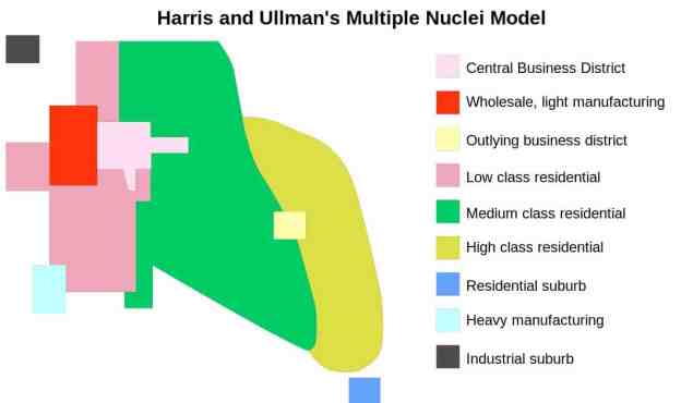 Multiple nuclei model of 1945