Sector Model of Urban Land Use

Urban areas have always been an area of research and caught the attention of scholars and academicians. Homer Hoyt gave the sector model which is also known as Hoyt model in 1939 explains how cities grew. As we witness the population growth it is becoming more and more essential to understand how cities work. Studies on patterns of urban growth, settlement geography, and land use are of great interest to the concerned people. Various theories and models have been proposed which attempts to explain how the growth took place and how different groups & activities are arranged in an urban area. Different models about the growth of urban regions include rank-size rule, primate city & primacy, central place theory, Multiple Nuclei Model, Burgess Model.

Homer Hoyt was a Land Economist, areal estate appraisor. He was a major figure in the development of suburban shopping centres in the decade after world war II

Hoyt Model or Sector Model (1939) of Urban Land Use by Homer Hoyt


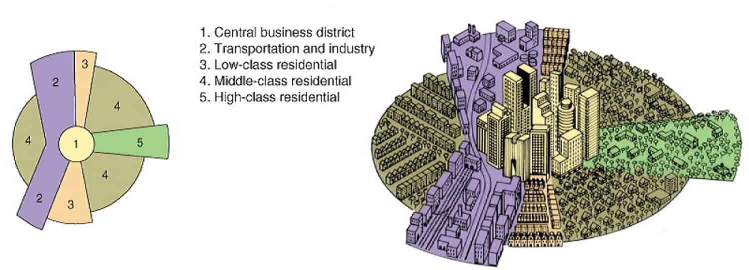
Hoyt Model is somewhat similar to Burgess Model and is often considered as its improved version. Hoyt argued that cities do not develop in the form of simple rings, instead, they have “sectors.” Homer Hoyt in 1939 suggested that few activities grow in the form of sectors which radiates out along the main travel links. Activities in a sector are considered to be the same throughout the sector because of the purpose/function it serves. Land use within each sector would remain the same because like attracts like. The high-class sector would stay high-class because it would be the most sought after area to live, so only the rich could afford to live there. The industrial sector would remain industrial as the area would have a typical advantage of a railway line or river. These sectors can be housing, industrial activities, etc. These sectors grow along railway lines, highways or rivers.

Components of Hoyt Model

CBD – Central Business District is placed at the center. Sectors and the partial rings of land use/activities take place. This area is often known as downtown and has high rise buildings. Inner-city area or downtown area is a complex and dynamic organism. It represents many layers of the historic growth of many generations impact of culture and traditions of men who inhabited the city as tourists. City grows layer by layer The combinations of these layers and the way they are held together in the city gives imageability, out of its socio-cultural heritage. As the cities expand and modern technology and scientific innovations transformed the style of living and also the structure of the city, open spaces were being eaten up by built forms resulting in a congested and unhealthy environment.

Industry – Industries is represented in the form of a sector radiating out from the center. These forms sector because of the presence of a transport linkage along which the activities grew. The presence of a railway line, river or road would attract similar activity, and thus a continuous corridor or “sector” will develop.

Hoyt Model or sector model

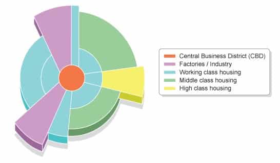
Apart from the industries this area also serves as a residential area for lower-class workers. Living conditions are bad because of the proximity to industries.

Low-Class Residential

Low-income groups reside in this area. Narrow roads, high population density, small houses with poor ventilation exist in this area. Roads are narrow and often connects to the industries where most of the people in this sector work. Closeness to industries reduces the travel cost and thus attracts industrial workers. Environmental and living conditions are often bad because of the proximity to factories.

Middle-Class Residential

This area has middle-income groups who can afford more substantial travel costs and want better living conditions. The activities of people residing in this area consist of different activities and not just industrial work. It has more linkages with CBD along with some linkages to industries. This area has the most significant residential area.

High Class residential

This is the outermost and farthest area from downtown. Wealthy and affluent people live in this area. This area is clean, has less traffic, quiet and has large houses. Corridor or spine extending from CBD to the edge has the best housing.

The significance of Hoyt Model 

  • Ecological factors + economic rent concept to explain the land use pattern
  • Stress on the role of transport routes in affecting the spatial arrangement of the city
  • Both the distance and direction of growth from the city center are considered
  • Brings location of industrial and environmental amenity values as determinants in a residential place
  • Example: Sectors of high-class residential areas tend to grow towards higher grounds, sites with a better view, more green space and open space, the homes of influential leaders within the community and existing outlying, smaller settlements.

Limitations of Sector Model 

  • Only Railway lines are considered for the growth of sectors and do not make allowances for private cars.
  • It is a monocentric representation of cities; multiple business centers are not accounted for in this model.
  • Physical features – physical features may restrict or direct growth along specific wedges
  • No reference to out of town development

Features of sector model

  • Presence of low-income groups near industries supports Hoyt Model
  • The Hoyt model realized that transportation (in particular) and access to resources caused a disruption of the Burgess model.
  • Transport linkages profoundly influence activities and their locations. Low transportation costs and proximity to roads/railway reduce the cost of production.
  • This model applies well to Chicago
  • Account for major transportation routes and its effect on activities


Source(s) and Link(s):

Planningtank

Slide Share

Posted in Class Notes, earth, urban morphology, Urban Studies | Leave a comment

Rural-urban Fringe: The Concept and History

Rural-Urban fringe is an important concept in settlement geography. The rural-urban fringe is the boundary zone outside the urban area proper where rural and urban land uses intermix. It is the area where the city meets the countryside. It is an area of transition from agricultural and other rural land uses to urban use. Located well within the urban sphere of influence the fringe is characterized by a wide variety of land use including dormitory settlements housing middle-income commuters who work in the central urban area. Over time the characteristics of the fringe change from largely rural to largely urban. Suburbanization takes place at the municipal boundary of rural-urban fringe.

Rural-Urban Fringe concept is about Land Use and Societ while the Concept of Umland is about services.

History of rural-urban fringe development:

  • There was widespread inner-city development immediately post WW2. But this did not create enough housing units for all those who needed them.
  • Others were built on the edge of towns and cities.
  • Most of the residential growth is outwards into the suburbs. Population density is lower than that in the inner city, and the houses are usually larger as the land is cheaper.
  • As residential use started spreading to the suburbs, transportation networks developed, increasing the connectivity of the suburbs to the inner city.
  • From the 1970s, out-of-town shopping centers took advantage of lower land prices and more space.
  • After that many companies moved their offices and factories to the edge of the urban area for similar reasons, where they could take advantage of better transport links as well.
  • From the late 1970s, many cities have lost population to counter-urbanization – people leaving the cities for a variety of reasons.
    • People want a better quality of life in a quieter, cleaner rural surrounding
    • More people are willing and able to travel further to work
    • Relocation of businesses to places with better transport links and cheaper building costs
    • Flexible working and new technology have increased part-time home working.
    • Retired people leave the city where they once worked.
  • This has led to the smaller towns and villages in areas with excellent communication links to expand – a lot of ‘in-filling’ has taken place. In-filling is building in gaps within the village or town boundary (known as the village/town envelope).

Factors for Increasing demand for land in the rural-urban fringe :

  • The land is cheaper – as the accessibility of the RUF is lower than that of the inner-city areas and most of the people have to travel to the inner city for work, fewer people are willing to live in the RUF. Thus the land prices are lower.
  • There is less traffic congestion and pollution – as the area is a new development in the outskirts, and the population living in the area is lesser than the inner city, the traffic congestion and pollution levels are lesser.
  • There is easier access and better road infrastructure – as it is a newer development with a lot of space available.
  • There is a more pleasant environment with more open space – the amount of open space decreases with time as the extent of development increases, and so does the friendly environment.

Beneficial development in the rural-urban fringe area:

The rural-urban fringe is characterized by a mixture of land uses, most of which require large areas of land.

  • Housing developments as urban sprawl continue
  • Science and business parks
  • Hypermarkets and superstores
  • Retail parks and out of town shopping centers
  • Office developments
  • Hotels and conference centers
  • Airport expansion

Housing developments

Housing demand is proliferating. Some of the reasons for this are:

  • a growing population
  • more elderly and retired people
  • more divorced and single people
  • increasing numbers of immigrants
  • more people buying second (holiday) homes

Problems caused by developing the rural-urban fringe:

  • Large areas of the countryside may be lost
  • Buildings may be out of character with existing rural buildings. Thus the loss of aesthetic sense
  • Villages may become suburbanized
  • Traffic is likely to increase (both cars and lorries)
  • there may be an increase in pollution (noise and air)

Issues in Urban-rural fringe

Uses  Positive Aspects Negative Aspects
Agriculture Many well-managed farms and smallholdings Farms often suffer litter, trespass, and vandalism; some land is derelict in the hope of planning permission
Development Some well-cited, carefully landscaped developments such as business and science parks Some developments, such as out of town shopping areas cause heavy traffic flow and pollution. Unregulated businesses such as scrap metal and caravan storage. Airport expansion
Urban Services Some, such as reservoirs or cemeteries, may be attractive. Mineral workings, sewage works, landfill sites, etc. can be unattractive and polluting
Transport New cycleways and footpaths can improve assess to the countryside Motorways destroy the countryside and promote new development, particularly near junctions.
Recreation and sport country parks, sports fields, and golf courses can lead to conservation. Some activities such as stock car racing and scrambling to erode ecosystems and create localized litter and pollution
Landscape and nature conservation Many SSSI (sites of special scientific interest) and AONB (Areas of natural beauty) Much degraded land, eg. land ruined by fly-tipping; many SSSIs under threat

A Helpful Video

Read about:

Source(s) and Link(s):

Planning Tank

Multiple Nuclei Model of 1945

Burgess Model or Concentric Model,

Central Place Theory

Rural-Urban continuum

Posted in earth | Leave a comment

International Women Day: Beyond gender roles, choice and equality

vishalbheeroo's avatarVishal Bhidu

A woman is beyond gender bender roles and expectations of who she is or stands for in our forever judgmental society. Watched at every single moment on how she looks, fat or skinny, pretty or disheveled, argumentative or submissive, aspersions cast on her character and what she decides to wear. Her body, her choice to drape in a sari, wearing a hijab, short skirt or swimsuit at the pool is lost by society, limited as we are as men and women pretending to hold a lense to judge.

The celebration of International Women Day on April 8 is one such day to reflect on the place women hold in society and no we don’t need tokenism to do that. Perhaps reminding ourselves and everyone that she is not just a body or tight-lipped listening silently to ‘obsolete’ rules made over the years. A woman is no doll in adhering to…

View original post 500 more words

Posted in earth | Leave a comment

Fog in Month of March in Aligarh!!

There was Dense Fog in Aligarh yesterday night. Normally there is no fog in this month. May it is due to climate change!!!

Posted in climate change, earth, Glimpses of Our Cities | Leave a comment