In the face of disaster, active citizens are already filling the governance gap; let’s upscale this now!

ramblinginthecity's avatarramblinginthecity

Owing to an attempted shift to more academic writing and partly in reaction to the few friends who haven’t been too thrilled with my use of this platform to rant, my posts over the past year have been fewer and less about opinion and more about experience. However, what’s the use of nurturing a blog of your own if you cannot occasionally rant!

My peeve today is, unsurprisingly, the flooding many cities across the world are experiencing and the general unpreparedness we have seen in dealing with them. Experts have attributed the higher incidents of flooding to changing patterns of precipitation (in the form of storms, rain, typhoons, cyclones), both in terms of the amount and the timing. Whether or not we link this to climate change, to me, is a moot point right now as we stare at mass destruction and anguish in Houston, eastern India, Nepal, Bangladesh and…

View original post 825 more words

Posted in earth | 2 Comments

Earth’s ICE RECORDS 

Ranjit Singh's avatarFree Thoughts by Ranjit Singh

Earth’s ICE RECORDSIce cores preserve climate history of million of years. Most of the ice cores are taken from the ice deposited in Antarctica and Greenland. Some interesting facts…

Ice cores have been preserved in US National Ice Core Library (NICL) in Denver Colorado.

  1. Oldest ice core record kept there is 420000 years old.
  2. In the library are ice cores collected and preserved from a single hole 3.6 kilometres.
  3. Total length of all the ice core samples preserved in the NICL is 20 kilometres.

Dust and chemicals trapped inside the ice samples can delineate the climatic conditions prevalent in the different times in the past. Climatic Histories upto 850000 years has been recreated.
How the age is determined??
Water like any other chemical contains normal oxygen 16 (O16)atom as well as a very small fraction of  oxygen 18 (O18)atoms. Water evaporation is a function of temperature. At higher temperatures O18…

View original post 47 more words

Posted in earth | Leave a comment

Asthenosphere

Asthenosphere is zone of Earth’s mantle (upper part of the mantle)lying beneath the lithosphere and believed to be much hotter and more fluid than the lithosphere. The asthenosphere extends from about 100 km to about 700 km  below Earth’s surface.

72142-004-c8723249

It was first named in 1914 by the British geologist J. Barrell, who divided Earth’s overall structure into three major sections: the lithosphere , or outer layer of rock-like material; the asthenosphere; and the centrosphere, or central part of the planet. The asthenosphere gets its name from the Greek word for weak, asthenis, because of the relatively fragile nature of the materials of which it is made. It lies in the upper portion of Earth’s structure traditionally known as the mantle.

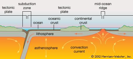
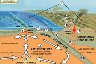
Heat from deep within Earth is believed to keep the asthenosphere malleable, lubricating the undersides of Earth’s tectonic plates and allowing them to move. Convection currents generated within the asthenosphere push magma upward through volcanic vents and spreading centres to create new crust. Convection currents also stress the lithosphere above, and the cracking that often results manifests as earthquakes. According to the theory of plate tectonics, the asthenosphere is the repository for older and denser parts of the lithosphere that are dragged downward in subduction zones.

pe4-asthenosphere

Tectonic plate interaction with the 
upper layers of the Earth
, USGS

Asthenosphere boundary is usually referred to as LAB. The asthenosphere is almost solid, although some of its regions could be molten (e.g., below mid-ocean ridges). The lower boundary of the asthenosphere is not well defined. The thickness of the asthenosphere depends mainly on the temperature. In some regions the asthenosphere could extend as deep as 700 km . It is considered the source region of mid-ocean ridge basalt (MORB).

References:

Encyclopedia Britannica

Wikipedia

Inside the Earth

Encyclopedia.Com


Posted in Class Notes, earth, Physical geography | 1 Comment

Discontinuities Inside the Earth

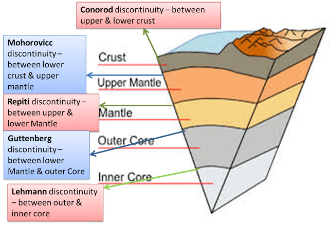
Earth’s interior is made of different kinds of materials. Each of  those materials are different from each other by their physical and chemical properties, such as temperature, density etc. Unique layers are there according to their characteristics inside the earth. All those layers are separated from each other through a transition zone. These  transition zones are called discontinuities.

      There are five discontinuies inside the earth.

Conrad Discontinuity:  Transition  zone between SIAL and SIMA.

Mohorovicic Discontinuity:  Transition zone between the Crust  and Mantle.

Repiti Discontinuity: Transition zone between Outer mantle and Inner mantle.

Gutenberg Discontinuity: Transition zone between Mantle and Core.

Lehman Discontinuity: Transition zone between Outer core and Inner core.
dis


Conrad Discontinuity:

   The transition zone between thee upper and lower part of the lithosphere, is called as Conrad discontinuity. The name come from the Austrian geophysicist  Vector Conrad . Up to the middle 20thcentury the upper crust in the continental region was seen to consist of felsic rock such as granite and the lower one consist of more magnesium rich mafic rocks such as basalt. Therefore, the seismologists of that time considered that Conrad discontinuity should correspond to a sharply defined contact between the chemically distinct  layers of  SIAL and SIMA.  In passing through the Conrad discontinuity the velocity of longitudinal seismic waves increases abruptly from approximately 6to6.5km/sec.


Mohorovicic Discontinuity:

  The transition zone  between the crust and mantle is called as mohorovicic discontinuity. The mohorovicic discontinuity was  discovered by Andrija Mohorovicic in the year of 1909. The Moho lies at the depth of 35km beneath the continents and 8km beneath the oceanic crust. The Moho separates both the continental crust and the oceanic crust from underlying mantle. The Moho lies almost  entirely within the lithosphere, only beneath the Mid Oceanic Ridge does it define lithosphere and asthenosphere boundary. Immediate above the Moho velocity of the P wave is 6km/sec and just below the Moho it becomes 8km/sec. Moho   is characterised  by up to 500km thick.

Gutenberg Discontinuity:

   The mantle –core transition zone is called Gutenberg discontinuity. In the year of 1912  Weichert Gutenberg was discovered this discontinuity at the depth of 2900km beneath the earth surface. In this zone the velocity of seismic waves changes suddenly. The velocity of P wave decreases and S wave completely disappear at this depth. S wave shear material and cannot transmit through liquid. So, it is believed that the part of above the discontinuity is solid and part of beneath then discontinuity is liquid or molten form. This molten section is thought to be 700°c, hotter than the overlying mantle. It is also denser, probably due to a  greater percentage of iron.

          It is a narrow ,uneven zone and contains undulations which may be up to 5-8km wide. This undulation is affected by the heat driven convection activity within the overlying mantle. These undulations are  also affected by the underlying eddies and current within the outer core iron rich fluids, which are ultimately responsible for earth magnetic field. Here it must be mentioned that the mantle core boundary does not remain constant. As the heat of the earth’s interior constantly but slowly dissipated, the molten core within earth solidifies and shrinks, causing the core mantle boundary to slowly move deeper and deeper within the earth’s core.

Repiti Discontinuity

it is the transition zone between Outer mantle and Inner mantle.

Lehmann discontinuity

It is the transition zone between outer and inner core. The Lehmann discontinuity is an abrupt increase of P-wave and S-wave velocities at the depth of 220±30 km, discovered by seismologist Inge Lehmann.It appears beneath continents, but not usually beneath oceans, and does not readily appear in globally averaged studies. Several explanations have been proposed: a lower limit to the pliable asthenosphere, a phase transition,[and most plausibly, depth variation in the  shear wave anisotropy.

Source(s):

Knowledge of Geography

Wikipedia

Posted in Class Notes, earth, Geographers, Physical geography | 10 Comments