
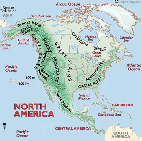
North America can be divided into five physical regions: the mountainous west, the Great Plains, the Canadian Shield, the varied eastern region, and the Caribbean. Mexico and Central America’s western coast are connected to the mountainous west, while its lowlands and coastal plains extend into the eastern region.
Western Region
Young mountains are found in the west. The most familiar of these mountains are the Rockies, North America’s largest chain. The Rockies stretch from the province of British Columbia, Canada, to the U.S. state of New Mexico.
The Rocky Mountains are part of a system of parallel mountain ranges known as the Cordilleras. A cordillera is a long series of mountain ranges. Although cordilleras exist all over the world, in North America, “the Cordilleras” indicate the massive mountain ranges in the western part of the continent. The Cordilleras extend from Canada all the way to the Isthmus of Panama.
The Sierra Madre mountain system is part of the Cordilleras. The Sierra Madre stretch from the southwestern United States to Honduras. The Sierra Madre include many high volcanoes (up to 5,636 meters) that stretch across Mexico south of the cities of Guadalajara and Mexico City.
Volcanic mountain ranges in Guatemala, Honduras, Nicaragua, Costa Rica, and Panama are also considered part of the Cordilleras. Volcanic eruptions and earthquakes occur frequently in this region. It contributes to the rich, fertile soils of the region.
Some of the Earth’s youngest mountains are in the Cascade Range of the U.S. states of Washington, Oregon, and California. The mountains include temperate rain forest—a biome unique to the area. The temperate rain forest receives an incredible amount of precipitation, between 254 to 508 centimeters annually.
The temperate rain forest supports a wide variety of life. The Sitka spruce, western red cedar, and Douglas fir are trees native to North America’s temperate rain forest. Some of these trees grow to more than 90 meters tall and 3 meters in diameter. Black bears, Roosevelt elk, and marmots are indigenous animal species.
The three major desert regions of North America—the Sonoran, Mojave, and Chihuahuan—are all in the American southwest and northern Mexico. These large deserts are located in the rain shadows of nearby mountains. The mountains block precipitation and accelerate the movement of hot, dry wind over these regions. The Sonoran is in the rain shadow of the Coast Ranges, the Mojave is in the shadow of the Sierra Nevada, and the Chihuahuan is in the shadow of the Sierra Madre.
Great Plains
The Great Plains lie in the middle of the continent. Deep, rich soil blankets large areas of the plains in Canada and the United States. Grain are grown ba plenty in this region hence it is called the “Breadbasket of North America,”. The region feeds a large part of the world. The Great Plains are also home to rich deposits of oil and natural gas.
The grassland or prairie regions of the Great Plains make up the largest biome in North America. Extreme weather prevents the growth of large plants but is perfectly suited to the native grasses that dominate the region.
Native grasses vary in size from 2 meters in tall grass prairies to only 20 or 25 centimeters in short grass prairies. Native animal species include bison, prairie dogs, and grasshoppers.
Canadian Shield
The Canadian Shield is a raised but relatively flatplateau. It extends over eastern, central, and northwestern Canada. The Canadian Shield is characterized by a rocky landscape pocked by an astounding number of lakes.
The Tundra, stretching along the northern borders of Alaska and Canada to the Hudson Bay area, is a biome common to the Canadian Shield. Tundra is where low temperatures and precipitation levels hinder tree growth. The tundra is characterized by permafrost—soil that is frozen for two or more years. This permafrost keeps moisture near the soil’s surface, promoting vegetation growth even in the extreme, Arctic conditions of the tundra.
During the summer, this top layer of soil thaws less than 10 centimeters (only a few inches) down, forming numerous shallow lakes, ponds, and bogs. Lichens, mosses, algae, and succulents take advantage of these shallow waters. In turn, they provide food for the caribou and musk ox that are typical of this area.
Eastern Region
This varied region includes the Appalachian Mountains and the Atlantic coastal plain.North America’s older mountain ranges, including the Appalachians, are near the east coast of the United States and Canada.
The Atlantic coastal plain extends from river, marsh, and wetland regions east of the mountains toward the sandy beaches of the Atlantic coast. Wetland areas are a biome of the eastern region and consist of areas of land whose soil is saturated with permanent or seasonal moisture. The Florida Everglades is the largest wetland system in the United States, covering more than 11,137 square kilometers) of southern Florida.
The Everglades is a biologically diverse region and contains several bordering ecosystems. Sawgrass marshes are the most iconic plant community of the Everglades and thrive on the slow-moving water of the wetlands. Alligators nest in the sawgrass, while wading birds such as egrets, herons, spoonbills, and ibises make their breeding grounds in other wetland tree species, such as cypress and mangrove.
Caribbean Region
The Caribbean Region includes more than 7,000 islands, islets, reefs, and cays. The region’s islands and smaller islets are varied in their topography; some have relatively flat and sandy terrain while others are rugged, mountainous, and volcanic.
The coral reefs and cays of the Caribbean Sea are among the most spectacular biomes in North America. A reef is a ridge of jagged rock, coral, or sand just above or below the surface of the sea. Some coral reefs surround islands, such as the Bahamas, Antigua, and Barbados. Others are found off the Florida Keys (a low bank or reef of coral, rock, or sand.

