
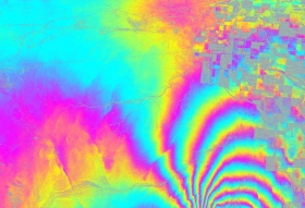
 Earthquakes are often imagined as opening up large gaps in the land, sinking islands and the such. It is much harder in real life to see this change. NASA has recently released the first ever airborne radar images of the deformation in Earth’s surface caused by a major earthquake — the magnitude 7.2 temblor that rocked Mexico’s state of Baja California and parts of the American Southwest on April 4, 2010. The data reveal that in the area studied, the quake moved the Calexico, Calif., region in a downward and southerly direction up to 31 inches.
Total Visitors
- 5,425,082
Search Inside
My You Tube Channel
-
Visitors on The Site

-
Join 782 other subscribers
Fill This Form to Contact Me
Top Posts & Pages
- Levant: The Term, The Region and Cities
- About Me and This Site
- Waste to Energy in India
- Migration Theories : Lee’s Push Pull Theory
- The Structure of the Ocean Floor(Ocean Topography)
- Discontinuities Inside the Earth
- Physical Divisions of North America: An Overview
- Indian Rivers
- Gond Tribe of India
- Social Geography: Concept,Origin,Nature and Scope
Being Social
Pages
- Article Submission
- Basics of Geography
- Book Reviews
- Disaster Management
- Field Training and Tour
- Geography Notes
- Geography of Tourism
- Geography Study Material for NTA-NET & IAS Exams
- Geomorphology
- Geomorphology Class Black Board
- Hindi Posts
- Human Geography
- My Projects
- New UGC NET Syllabus-Geography
- Online Class
- Posts on Geography Practicals and Statistical Techniques
- Regional Studies
- Settlement Geography
- Social Geography
- Urban Agro Systems
- Urban Systems
- Useful Links
- Water Resources
- About Me and This Site
Blogroll
Digital Blackboards
My Pages
Other Sites I Am Involved With
Recommended Links
Useful Links

