
A road which was rebuilt throughout the centuries and which today survives as the Grand Trunk Road. Thus Sher Shah Shuri in the 16th century did not lay the foundation stone for a new road but had merely reconstructed what existed for centuries.
In around 3rd century BC, as the Mauryan Empire was flourishing, a road was built to the main centre of learning ‘Taxila’ and later even further up to Balkh in Khurasan (now in Afghanistan) from Patiliputra (now Patna). This road was used by every traveller who had to cross Khyber Pass and enter into the Hind. The same route was used by invaders like Ghori and Ghazni. With time, the road reached the eastern end of empire, which today falls deep inside Bangladesh. A Greek observer recorded that Samrat Chandragupta Maurya poured manpower to maintain this road. This road is mentioned in several ancient texts and appears as “Uttarpath” (Northern-Road)
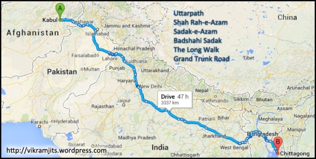
Sher Shah Suri decided to restore this ancient path and make it more useful. He deployed enormous labour to revive the Uttarpath and connected his hometown Sasaram to Agra. He died soon after that, the Mughals that came afterwards connected Kabul (Afghanistan) with Chittagong (Bangladesh) using this road. Today, this road connects the capitals of 4 countries and covers a total distance of 2500 kilometres (1600 miles). During this time, this road was known by many names, eg: Shah Rah-e-Azam (“Great Road”) or Sadak-e-Azam or Badshahi Sadak.
In 18th century, as the British came, they maintained this road and later converted it to a motorable road. They started calling it the “Grand Trunk Road”, sometimes also referring to it as the “Long Walk”. During that period, it was maintained between Howrah and Peshawar.
Kos Minars
Afghans & Mughals built ‘Kos Minars’ at each ‘Kos’ (ancient measuring unit with 1 Kos approximately equal to 1.8 Km). They also built forts and most important, Caravan Serais (Inns) at regular distances. These Serais had a mosque, rooms for travellers, area reserved for animals and lot more to offer to travellers than they can ask for while travelling for thousands of kilometres. Many of these Serais are lost, but most of them still exist. Today, huge urban settlements have come up around those historic serais and the only way to identify is to check the name of locality, as most of them still use the old serai names.


Pingback: Salient Features of Indian Road Network and Highways | Rashid's Blog
Pingback: Varanasi: An Old City of India and an Enigma | Rashid's Blog
Pingback: List of National Highways in India With Length | Rashid's Blog