Air Masses: A large Body of Air

An air mass is a large body of air that has similar temperature and moisture properties throughout. The best source regions for air masses are large flat areas where air can be stagnant long enough to take on the characteristics of the surface below. Maritime tropical air masses (mT), for example, develop over the subtropical oceans and transport heat and moisture northward into the U.S.. In contrast, continental polar air masses (cP), which originate over the northern plains of Canada, transport colder and drier air southward.
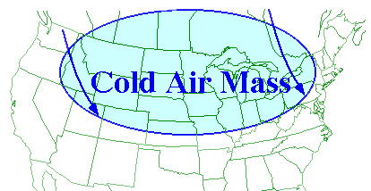
Once an air mass moves out of its source region, it is modified as it encounters surface conditions different than those found in the source region. For example, as a polar air mass moves southward, it encounters warmer land masses and consequently, is heated by the ground below. Air masses typically clash in the middle latitudes, producing some very interesting weather.

Source of an air mass

The temperature of an air mass will depend largely on its point of origin, and its subsequent journey over the land or sea. This might lead to warming or cooling by the prolonged contact with a warm or cool surface. The processes that warm or cool the air mass take place only slowly, for example it may take a week or more for an air mass to warm up by 10 °C right through the troposphere. For this to take place, an air mass must lie virtually in a stagnant state over the influencing region. Hence, those parts of the Earth’s surface where air masses can stagnate and gradually attain the properties of the underlying surface are called source regions.

The main source regions are the high pressure belts in the subtropics, which produce tropical air masses, and around the poles, that are the source of polar air masses.

Air-mass modification

It is in the source regions that the air mass acquires distinctive properties that are the characteristics of the underlying surface. The air mass may be cool or warm, or dry or moist. The stability of the air within the mass can also be deducted. Tropical air is unstable because it is heated from below, while polar air is stable because it is cooled from below.

As an air mass moves away from its source region towards the British Isles, the air is further modified due to variations in the type or nature of the surface over which it passes. Two processes act independently, or together, to modify an air mass.

An air mass that has a maritime track, i.e. a track predominantly over the sea, will increase its moisture content, particularly in its lower layers. This happens through evaporation of water from the sea surface. An air mass with a long land or continental track will remain dry.

A cold air mass flowing away from its source region over a warmer surface will be warmed from below making the air more unstable in the lowest layers. A warm air mass moving over a cooler surface is cooled from below and becomes stable in the lowest layers

links:

http://ww2010.atmos.uiuc.edu

Air Massws :Wikipedia

Air masses and fronts

Posted in earth, Ecosystem, Environment, Winds | Tagged , , | 3 Comments

Indian Govt Approves GAGAN – In place by 2011

In a bid to provide seamless navigation over the Indian airspace and waters, the Indian government has approved the implementation of a Rs 774-crore Global Positioning System (GPS) aided futuristic project.The GPS aided Geo Augmented Navigation (GAGAN) project would place India in a select group of nations. Commenting on the development, Civil Aviation Minister Praful Patel said the GAGAN system would be “certainly in place by 2011” and would make “flying much safer than at present”. It would also improve airport and airspace access in all-weather conditions and provide precision-landing approaches to aircraft even at airports, where Instrument Landing Systems do not exist.

Source : Press Trust of India

Posted in News | Leave a comment

Chandrayan-II:India Planning to Land a Rover on the Moon


The Indian Space Research Organisation will finalise details of Chandrayaan-II in six months, said Chairman G. Madhavan Nair.

Talking to reporters on the sidelines of the 58th International Astronautical Congress here, he said the ISRO would consider sending a lander-rover, which can move on the surface of the moon. The conceptual design for the project was being evolved.

As for Chandrayaan-I, the ISRO was building the spacecraft. It would carry two instruments from the United States and also payloads from European countries including Bulgaria. However, the primary missions would be carried out with six Indian instruments.

Chandrayaan-I was mostly a remote-sensing spacecraft, meant for scanning the lunar surface for minerals and water.

The next project would look at the possibility of collecting samples and analysing them on the spot. Though Chandrayaan-II was basically an Indian mission, the ISRO would consider participation by other countries case by case if they showed interest in it.

Asked whether India had plans to participate in the International Space Station, Mr. Nair said, “We don’t have a meaningful proposal to conduct any experiment”.

On the proposed 60 ISRO missions, he said a series of communication and earth observation satellites including Oceansat and the radar imaging satellite had been lined up to meet national needs.

The capacity of the communication satellite was proposed to be increased from 200 to 500 transponders. This would require 10 missions to complete.

Also planned were 10-12 earth observation satellites and another 10 communication satellites. The GSLV Mark-III would be operational in two years.

“In situ chemical analysis and resource exploration is the main objective of Chandrayaan-II,” a scientist associated with the mission said.

India had begun initial technical discussions on Chandrayaan-II which is expected to be a much shorter mission than Chandrayaan-I scheduled for launch later this year.

An agreement for Chandrayaan-II was signed by Indian Space Research Organisation (ISRO) and Roskosmos, the Russian Federal Space Agency during Prime Minister Manmohan Singh’s visit to Moscow in November last year.

Mineral samples from the moon contained Helium 3, a variant of the gas used in refrigerators, and Chandrayaan-II will also look out for the gas which experts believe may offer a solution to energy shortages. The current Chinese moon mission is also exploring this prized source of energy.

Chandrayaan-II will benefit from the country’s maiden moon mission which will survey the lunar surface to produce a complete map of its chemical characteristics and 3-dimensional topography over a two-year period.

The survey of the lunar surface will help scientists identify the exact place for landing the rover and strategic locations to carry out experiments.

ISRO recently established a 32-meter diameter antenna at Byalalu near Bangalore for providing tracking and command support for Chandrayaan-I.

The antenna and associated systems are the first steps in building the Indian Deep Space Network (IDSN), that is vital for facilitating a two-way radio communication link between the spacecraft and the earth.

The DSN-32 project will provide ISRO the capability to handle deep space missions besides allowing it to extend cross-support to similar missions by other nations because of its inter-operable features, world standards specifications and state-of-the-art capabilities.

Besides six Indian instruments, the mission is carrying payloads from the US, Germany, France, the UK and Sweden.

“All systems are progressing as per schedule for April 2008 launch,” a scientist said.

The first phase will predominantly have remote sensing equipment like X-rays and gamma and laser imaging machines.

The remote sensing satellite will weigh 1,304 kgs (590 kg initial orbit mass and 504 kg dry mass) and carry high resolution remote sensing equipment for visible, near infra-red, soft and hard X-ray frequencies.

Links:

Economic Times
The Hindu

image link

Posted in earth, India' Moon Mission, News, Remote Sensing 101, Solar System | Tagged , , | Leave a comment

Cloud burst:Sudden Copious Rain

A cloudburst is sudden copious rainfall. It is a sudden aggressive rainstorm falling for a short period of time limited to a small geographical area.

They are called ‘bursts’ probably because it was believed earlier that clouds were solid masses full of water. These violent storms were attributed to their bursting.

There are similar names for such events in other languages. For example, in Polish the equally vague term used is “Oberwanie Chmury”.

Meteorologists say the rain from a cloudburst is usually of the shower type with a fall rate equal to or greater than 100 mm (4.94 inches) per hour.

Generally cloudbursts are associated with thunderstorms. The air currents rushing upwards in a rainstorm hold up a large amount of water.

If these currents suddenly cease, the entire amount of water descends on to a small area with catastrophic force all of a sudden and causes mass destruction. This is due to a rapid condensation of the clouds.

They occur most often in desert and mountainous regions, and in interior regions of continental landmasses.

Cloudbursts descend from very high clouds, sometimes with tops above 15 kilometers. Meteorologists say the rain from a cloudburst is usually of the shower type with a fall rate equal to or greater than 100 mm (4.94 inches) per hour.

During a cloudburst, more than 2 cm of rain may fall in a few minutes. When there are instances of cloudbursts, the results can be disastrous.

Rapid precipitation from cumulonimbus clouds is possible due to so called Langmuir precipitation process in which large droplets can grow rapidly by coagulating with smaller droplets which fall down slowly.

During a cloudburst, more than 2 cm of rain may fall in a few minutes. They are called ‘bursts’ probably because it was believed earlier that clouds were solid masses full of water. So, these violent storms were attributed to their bursting.

One of the major disasters from a cloudburst in India occurred in 2002 in Uttaranchal. Some 28 people died when villages like Marwari, Kotsisham, Matgoan and Agonda were hit by sudden cloudbursts.

Cloudbursts frequently occur in Himachal Pradesh during the monsoon.

World Record Cloudbursts

1 minute: 1.5 inches (38.10 mm) at Barot, Guadeloupe, 26 November 1970.
5 minutes: 2.43 inches (61.72 mm) at Port Bells, Panama, 29 November 1911.
15 minutes: 7.8 inches (198.12 mm) at Plumb Point, Jamaica, 12 May 1916.
20 minutes: 8.1 inches (205.74 mm) at Curtea-de-Arges, Romania, 7 July 1947.
40 minutes: 9.25 inches (234.95 mm) at Guinea, Virginia, USA, 24 August 1906.

On August 14, 2007, at least 100 people were feared washed away in flash floods caused by cloudburst at a village near Shimla, India.
In July 2007, close to 30,000 people were displaced in Kerala after a cloudburst & flash floods following it

Links:

http://www.rediff.com

Image link

Wikipedia

Posted in rain | 3 Comments