
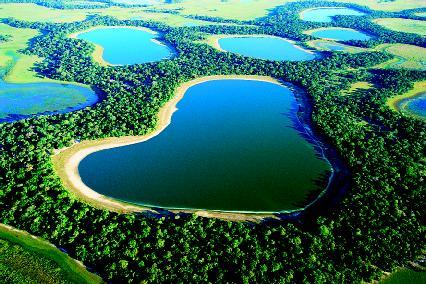
The Pantanal, which covers more than 77,000 square miles in Brazil, is considered one of Earth's richest ecosystems. It is a landscape of swamps, seasonally flooded grasslands and woodlands, and different types of forest
Floodplains are landscapes shaped by running water. As streams and their larger forms, rivers, flow across the surface of land, they transport eroded rock and other material. (Erosion is the gradual wearing away of Earth surfaces through the action of wind and water.) At points along that journey, when their flow slows, the material they carry is dropped to create what are termed depositional landforms. Among these landforms are deltas and floodplains. (For further information on deltas, see the Delta chapter.)
The flooding of a stream or river is a natural and recurring event. Ancient cultures that lived along these waterways welcomed the flooding of the adjacent land. The material deposited enriched the soil, increasing its fertility for farming. For those along the Nile River in ancient Egypt, the annual flood was the “gift of the Nile.” In many modern societies, however, the lands bordering rivers and streams are sites of homes, businesses, and other urban development. The flooding of this land is often a costly natural disaster.

Part of the upper Mississippi River cutting through sandstone. The river's floodplain encompasses more than 30 million acres and mostly occurs adjacent to the lower Mississippi
A floodplain (sometimes spelled flood plain) is an area of nearly flat land bordering a stream or river that is naturally subject to periodic flooding. A flood occurs when the flow of water in a stream becomes too high to be accommodated in the normal stream channel. The channel of a stream is the trench or depression filled with water as it flows across a landscape. The sides of the channel are known as the stream’s banks. The bottom is the stream bed.
In a flood, water flows over the stream’s banks, submerging the adjacent land. Depending on the amount of water, the flood may cover all or part of the floodplain. As water flows out of the stream’s channel, it immediately slows down. The material carried by the stream—sediment such as gravel, sand, silt, and clay—is deposited on the floodplain. Large particles are deposited first, and much of this material is laid down alongside both banks. This process, repeated over and over, forms low ridges or mounds known as natural levees (pronounced LEH-veez). Levees built by humans along rivers in an effort to control flooding are known as artificial levees. Natural levees are composed primarily of gravel and sand. They are steep on the side facing the stream channel and gently sloping on the other side. Varying greatly in size, levees may be several feet in height and up to a mile or more in width.
The finer sediments transported by the floodwater, silt and clay, are deposited on the floor of the floodplain away from the levees. The general term for sediment deposited by running water is alluvium (pronounced ah-LOO-vee-em). Because floodplains are covered with alluvium, they are often called alluvial plains. Lower, poorly drained areas on the floodplain that not only collect alluvium but also retain water are known as backswamps.
Floodplains are widened as a stream snakes its way across a landscape. Streams and rivers rarely flow in straight lines. They have a natural tendency to flow along a path of least resistance, eroding any soft material along their banks. Because of this, many stream channels form a series of smooth bends or curves called meanders (pronounced me-AN-ders). The term comes from the Menderes River in southwest Turkey, which is noted for its snakelike or winding course. As a stream begins to meander, erosion will take place on the outer parts of the bends or curves where the velocity or speed of water is highest. These eroded areas are called cut banks. Sediment will be deposited along the inner bends where the velocity is lowest. These deposits are known as point bars. As erosion and deposition continues, a stream tends to change shape and shift position across its floodplain, which enlarges in response to the stream’s back-and-forth movement.
Eventually, a meander forms a tighter and tighter curve until it almost becomes a complete loop. The stream then shortens its course by eroding through the intervening land or neck of the loop, especially during times of flooding. Sediment is deposited, isolating the meander from the stream. Still filled with water, the crescent-shaped meander is called an oxbow lake (because it resembles the U-shaped collar used with teams of oxen). In Australia, an oxbow lake is known as billabong (pronounced bill-ah-BONG); in Louisiana and Mississippi, it is sometimes called a bayou (pronounced BY-oo). Over time, as the floodplain is repeatedly submerged under water, alluvium fills an oxbow lake, turning it into a marsh and eventually into a meander scar. The dry meander scar, which typically only holds water during rains, still retains the shape of the original meander.
A small stream that enters a floodplain and flows alongside a larger stream or river for quite a distance is known as a yazoo stream or yazoo tributary. It helps drain the floodplain, but is often prevented from joining the main stream by the stream’s natural levee. Only when it finds a low or weak place in the levee does it flow naturally into the larger stream. The term describing this type of small stream comes from the Yazoo River, which flows parallel to the Mississippi River for 175 miles (282 kilometers) before it joins with the larger river.
Over long periods of time, a stream or river may erode its bed down to a lower level, putting its old floodplain out of reach of flooding. A new floodplain then forms with the old floodplain standing above its outer edges in the form of a flat bench. This exposed portion of the former floodplain is known as a terrace.
Running water is the primary force of erosion on the planet. Streams and major rivers are continuously at work moving rock fragments and dissolved materials from elevated landmasses to oceans, lakes, and other streams and rivers. Worldwide, streams transport 16 billion tons (14.5 billion metric tons) of sediment per year. They alter landscapes through both erosion and deposition.


