Mesa and butte

Junction Butte in Canyon-lands National Park, Utah. Part of the Colorado Plateau, the landscape of sedimentary sandstone in this area was eroded into countless canyons, mesas, and buttes by the Colorado River and its tributariesJunction Butte in Canyon-lands National Park, Utah. Part of the Colorado Plateau, the landscape of sedimentary sandstone in this area was eroded into countless canyons, mesas, and buttes by the Colorado River and its tributaries

Spanish explorers in the mid-sixteenth century ranged over the American Southwest. They had come north from Mexico, looking for gold and gems and the legendary Seven Cities of Cibola (pronounced SEE-bow-lah), allegedly filled with such treasures. In their quest, they found neither gold nor riches. They did, however, become the first Europeans to view the geological wonders of the area, and they were amazed at what they saw.

The Enchanted Mesa, in Acoma Pueblo, New Mexico, rises 430 feet from the desert valleyThe Enchanted Mesa, in Acoma Pueblo, New Mexico, rises 430 feet from the desert valley

Among the canyons, plateaus, and rock towers and arches, the explorers saw landforms that appeared plateaulike, only smaller and isolated. They called these geologic features mesas (pronounced MAY-suz), which means table in Spanish, because the explorers thought the landforms resembled tables with their smooth, flat tops and sides that drop away steeply. Populating the spare, arid (dry) landscape of the area along with mesas were still smaller landforms that had a similar appearance. At the beginning of the nineteenth century, the word butte (pronounced BYOOT) was coined from the French word meaning mound or hillock to describe these solitary landforms.
The shape of the land

A mesa is an isolated, flat-topped hill or mountain with steep sides that is smaller in area than a plateau. A butte is also a flat-topped hill with steep sides, though smaller in area than a mesa. Definitions of the surface areas of mesas and buttes vary. One source states that a mesa has a surface area of less than 4 square miles (10 square kilometers), while a butte has a surface area less than 11,250 square feet (1,000 square meters). Another source states that the surface area of a mesa is larger than 1 square mile (2.59 square kilometers); the surface area of a butte is smaller than that dimension. Some simply define a mesa as a landform that is wider than it is high and a butte as one that is higher than it is wide.

A mesa’s and butte’s characteristic shape—flat top and clifflike sides—is due to the layers of rock forming them. These landforms are most often composed of sedimentary rock, formed by the accumulation and compression of sediment (which may consist of rock fragments, remains of microscopic organisms, and minerals). This type of rock covers more than 75 percent of Earth’s land surface. Most sedimentary rocks occur in layers, called strata, that are mostly horizontal or flat when first formed. Forces within Earth that rupture the surface to form volcanoes, mountains, plateaus, and many other topographical features (physical features on the planet’s surface), may later cause these layers to tip, fold, warp, or fracture.

The top layer of a mesa and a butte is a hardened layer of rock that is resistant to erosion, which is the gradual wearing away of Earth surfaces through the action of wind and water. Sometimes this top layer, called the cap rock, is not sedimentary rock but is cooled and hardened lava that had spread out across the landscape in repeated flows from fissures or cracks in the ground. Beneath this flat protective cap of rock are horizontal layers of softer sedimentary rock. To varying degrees, these layers are not as resistant to erosion.

These landforms are found in arid and semiarid regions. Arid regions are defined as those that receive less than 10 inches (25 centimeters) of rain per year; semiarid regions receive 10 to 20 inches (25 to 50 centimeters) of rain per year. Precipitation in these regions often comes in the form of sudden, heavy rainfalls. Because water evaporates quickly in these normally dry environments, plants and other ground cover are scarce. Left exposed to the action of running water, the bare sides of the softer rock layers of mesas and buttes are eroded away over time. The base of these landforms is often gently sloped, contrasting with the almost-vertical sides leading down from the top. Rock material that has been eroded from the sides is carried downward, forming this sloping base.

source

Posted in Landforms | 1 Comment

Layers of Earth’s Atmosphere

The temperature of the Earth’s atmosphere varies with altitude; the mathematical relationship between temperature and altitude varies among five different atmospheric layers (ordered highest to lowest, the ionosphere is part of the thermosphere):
Exosphere: from 500 – 1000 km (300 – 600 mi) up to 10,000 km (6,000 mi), free-moving particles that may migrate into and out of the magnetosphere or the solar wind.
exobase boundary
Ionosphere: the part of the atmosphere that is ionized by solar radiation. It plays an important part in atmospheric electricity and forms the inner edge of the magnetosphere. It has practical importance because, among other functions, it influences radio propagation to distant places on the Earth. It is located in the thermosphere and is responsible for auroras.
thermopause boundary
Thermosphere: from 80 – 85 km (265,000 – 285,000 ft) to 640+ km (400+ mi), temperature increasing with height.
mesopause boundary
Mesosphere: From the Greek word “μέσος” meaning middle. The mesosphere extends from about 50 km (160,000 ft) to the range of 80 to 85 km (265,000 – 285,000 ft), temperature decreasing with height. This is also where most meteors burn up when entering the atmosphere.
stratopause boundary
Stratosphere: From the Latin word “stratus” meaning a spreading out. The stratosphere extends from the troposphere’s 7 to 17 km (23,000 – 60,000 ft) range to about 50 km (160,000 ft). Temperature increases with height. The stratosphere contains the ozone layer, the part of the Earth’s atmosphere which contains relatively high concentrations of ozone. “Relatively high” means a few parts per million—much higher than the concentrations in the lower atmosphere but still small compared to the main components of the atmosphere. It is mainly located in the lower portion of the stratosphere from approximately 15 to 35 km (50,000 – 115,000 ft) above Earth’s surface, though the thickness varies seasonally and geographically.
tropopause boundary
Troposphere: From the Greek word “τρέπω” meaning to turn or change. The troposphere is the lowest layer of the atmosphere; it begins at the surface and extends to between 7 km (23,000 ft) at the poles and 17 km (60,000 ft) at the equator, with some variation due to weather factors. The troposphere has a great deal of vertical mixing because of solar heating at the surface. This heating warms air masses, which makes them less dense so they rise. When an air mass rises, the pressure upon it decreases so it expands, doing work against the opposing pressure of the surrounding air. To do work is to expend energy, so the temperature of the air mass decreases. As the temperature decreases, water vapor in the air mass may condense or solidify, releasing latent heat that further uplifts the air mass. This process determines the maximum rate of decline of temperature with height, called the adiabatic lapse rate. The troposphere contains roughly 80% of the total mass of the atmosphere. Fifty percent of the total mass of the atmosphere is located in the lower 5.6 km of the troposphere.

The average temperature of the atmosphere at the surface of Earth is 15 °C (59 °F).
dig deeper

Posted in earth, Environment | 3 Comments

Greenhouse gas 4 times higher than thought

Levels of a powerful greenhouse gas are four times as high as previously thought, according to new measurements released on Thursday.

New analytical techniques show that about 5,400 metric tons of nitrogen trifluoride are in the atmosphere, with amounts increasing by about 11 percent per year.

Ray Weiss of the Scripps Institution of Oceanography in La Jolla, California, and colleagues said it had not been possible to accurately measure this gas before.

They said nitrogen trifluoride is 17,000 times more effective at warming the atmosphere than an equal mass of carbon dioxide, although it does not yet contribute much to global warming.

Previous estimates had put levels of the gas at less than 1,200 metric tons in 2006.

source

Posted in Environment, Global Warming, News | Leave a comment

Canyons

Canyons exist below the rim of the land, below the horizon. These ragged scars on the face of the planet descend hundreds to thousands of feet below their surrounding landscape, giving it depth. Their widths may stretch for miles or mere feet. Sunlight may fill them or may never reach their darkened bottom regions. Winding through many is water, possibly the most powerful force on the planet.

Sudden, tremendous events in Earth’s history did not produce these landforms. Instead, it was mainly the slow, orderly process of erosion, the wearing away of the planet’s surface through the action of wind and water. While wind has played a part in their formation, its effect has been subtle. The true creator of a canyon is water, primarily in the form of a river. Over millions of years, water has scoured and cut away layer upon layer of rock, lowering a canyon’s floor and widening its walls. Although perhaps much more slowly, canyons created millions of years ago continue to be shaped in the present day. The erosive power of water is unrelenting.

The shape of the land

A canyon may be defined as a narrow, deep, rocky, and steep-walled valley carved by a swift-moving river. Its depth may be considerably greater than its width. Some sources use the words gorge, ravine, and chasm interchangeably with canyon. Others say they are all variations of steep-sided valleys normally with a stream or river flowing through them. A few make the distinction that canyons are usually found in arid (dry) regions characterized by plateaus, which are relatively level, large expanses of land that rise some 1,500 feet (457 meters) or more above their surroundings and have at least one steep side.

Canyons are incredibly diverse in their forms. The walls of some canyons are V-shaped and ragged; the walls of others are steeper and almost

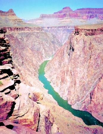
Inner gorge of the Grand Canyon, located in northwestern Arizona. Carved by the power of the Colorado River, the canyon stretches for 277 miles. PHOTOGRAPH REPRODUCED BY PERMISSION OF HENRY HOLT AND COMPANY.
Inner gorge of the Grand Canyon, located in northwestern Arizona. Carved by the power of the Colorado River, the canyon stretches for 277 miles.

smooth. Some canyons have been carved through sandstone and limestone and other types of sedimentary rock (rock formed by the accumulation and compression of sediment, which may consist of rock fragments, remains of microscopic organisms, and minerals). Others have been carved through multiple layers of igneous (pronounced IG-nee-us) rock, which is formed by the cooling and hardening of magma, melted rock material from within Earth, and metamorphic (pronounced meh-tah-MORE-fik) rock, whose texture or composition has been changed by extreme heat and pressure. Some canyons are dry; others are filled with rushing rivers. Some cover vast spaces; others are so narrow a person can barely squeeze through the walls.

source

Posted in oceans, water | Leave a comment