
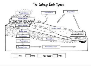
 The land based part of the hydrological cycle is called the Drainage Basin System. A drainage basin is the name given to the area of land which is drained by a river. When water reaches the surface there are a number of routes which it may take in its journey to reach the river. These are shown in the diagram .
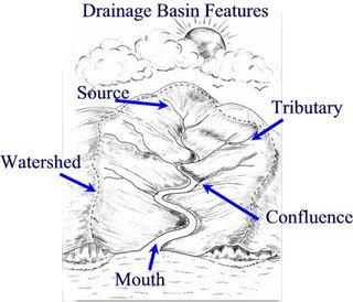 Drainage Basins have a number of distinct features . The edge of a drainage basin is characterised by the highest points of land around the river, this is known as the watershed. The point at which a river starts is called its source. As the river continues to flow down stream it may be joined by smaller rivers called tributaries. The point at which these smaller rivers join the main river is known as a confluence. As the river continues its journey, eventually reaches the sea – the point where the river flows into the sea is known as the river mouth.
Links:


Pingback: Some Desert Related Geographic Terms | Rashid's Blog
Pingback: Ocean basin | Rashid's Blog
Pingback: Folds:Types and Folding Mechanism | Rashid's Blog