
The features of continental landscapes are mirrored by similar features on the ocean basins. Plateaus, plains, valleys, rolling hills, and volcanic cones and mountains are found beneath the waters of the oceans, just as they are on dry land. Yet the largest underwater mountains are higher than those on the continents, and underwater plains are flatter and more extensive than their dry counterparts. These “oceanscapes,” at one time unseen and unknown, may resemble familiar landscapes, but on a much grander scale.
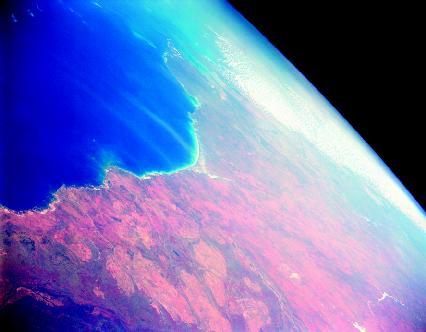
Canning Basin, western Australia. Ocean basins are that part of Earth’s surface that extends seaward from the continental margins.
The shape of the land
Ocean basins are that part of Earth’s surface that extends seaward from the continental margins (the submerged outer edges of continents, each composed of a continental shelf and a continental slope). Basins lie at an average water depth of about 12,450 feet (3,795 meters). From there they drop steeply down into the deepest trenches. The oceans and seas of the planet form a layer of water that covers approximately 71 percent of Earth’s surface. Ocean basins occupy more than 76 percent of the total ocean area.
Many sources include the continental margins as part of the ocean basins, but the margins are the drowned edges of the continents. They are part of the same crust (thin, solid outermost layer of Earth) that forms the continents. The transition between continental crust and oceanic crust occurs in the continental slope. Continental crust is composed mostly of granite, whereas oceanic crust is mostly basalt. Although they differ in composition, both are types of igneous rock that forms when magma cools and solidifies. Granite forms when magma with a high silica content cools slowly deep beneath Earth’s surface; basalt forms when magma with a low silica content cools quickly outside of or very near Earth’s surface.
By ocean basins, this discussion is referring to what may be termed the deep-ocean basins: those areas of the ocean floor lying more than 10,500 feet (3,200 meters) beneath the surface of the oceans. The four main ocean basins are those of the Pacific, Atlantic, Indian, and Arctic Oceans. The Pacific Ocean, which occupies about one-third of Earth’s surface, has the largest basin. Its basin also has the greatest average depth at approximately 14,000 feet (4,300 meters). The Atlantic Ocean basin is half the size of that of the Pacific Ocean and is not quite as deep, averaging about 12,000 feet (3,660 meters). While slightly smaller in size than the Atlantic Ocean basin, the Indian Ocean basin sits at a lower average depth, 12,750 feet (3,885 meters). The Arctic Ocean basin is less than 10 percent the size of the Pacific Ocean basin and lies at an average depth of 3,900 feet (1,190 meters).
All ocean basins contain certain primary features: mid-ocean ridges, abyssal (pronounced ah-BISS-ul) plains, trenches, and seamounts.
Perhaps the most impressive features found on all ocean basins are long, continuous volcanic mountain ranges called mid-ocean ridges. These elevated ridges mark the area where sections of oceanic crust are pulling apart from each other. As they do, hot magma (liquid rock) emerges from beneath the crust and seeps forth as lava to fill the crack continuously created by the separation. The lava cools and attaches to the trailing edge of each section, forming new ocean floor crust in a process known as seafloor spreading. Additional lava is deposited by the thousands of volcanoes that periodically erupt along the ridges.
The large depression that is created between the spreading sections is known as a rift valley. Mid-ocean ridges are divided into three groups depending on their spreading rates: slow, medium, and fast. Ridges that spread slowly, from 0.4 to 2 inches (1 to 5 centimeters) per year, have a wide and deep central rift valley. The valley may be 6 miles (10 kilometers) wide and 2 miles (3 kilometers) deep below the crests, or tops, of the ridges that surround it on either side. Ridges that are classified as medium spread at a rate of 2 to 4 inches (5 to 10 centimeters) per year. The valleys of these ridges may be up to 3 miles (5 kilometers) across and range in depth from 165 to 655 feet (50 to 200 meters). Finally, fast-spreading ridges open up at a rate of 4 to 8 inches (10 to 20 centimeters) per year. Their rift valleys are much smoother in appearance. On average, these small valleys are only 330 feet (100 meters) wide and 33 to 66 feet (10 to 20 meters) deep.
In most locations, mid-ocean ridges are 6,500 feet (1,980 meters) or more below the surface of the oceans. In a few places, however, they actually extend above sea level and form islands. Iceland (in the North Atlantic), the Azores (west of the coast of Portugal), and Tristan de Cunha (in the south Atlantic midway between southern Africa and South America) are examples of such islands.
The most-studied mid-ocean ridge in the world is the Mid-Atlantic Ridge. It begins at the tip of Greenland and runs down the center of the Atlantic Ocean between the Americas on the west and Europe and Africa on the east. It ends its course at the southern tip of the African continent. At that point, the ridge continues around the eastern edge of Africa as the Southwest Indian Ridge. That ridge then divides near the center of the Indian Ocean basin into the Central Indian Ridge that runs north into the African continent and the Southeast Indian Ridge that runs east below the Australian continent. The ridge continues eastward along the southern portion of the Pacific Ocean basin as the Pacific Antarctic Ridge. It eventually heads northward along the western coastline of South and Central America as the East Pacific Rise.
These mid-ocean ridges combine to form a global undersea mountain system known as the mid-ocean ridge system. Extending more than 40,000 miles (64,000 kilometers), it is the longest topographic or surface feature on Earth. Snaking its way between the continents, the ridge system encircles the planet like the seams on a baseball. Whereas the seams form a continuous loop, the mid-ocean ridge system is offset in many places. The offsets are called fracture zones. These breaks in the ridge line are caused by faults, cracks or fractures in Earth’s crust along which rock on one side has moved relative to rock on the other. Ocean crust on either side of a fault in a fracture zone slides in opposite directions. This helps relieve tension created when different sections of a mid-ocean ridge spread at different rates. The faults form deep, linear gouges almost perpendicular to the ridges. Crust in a fracture zone looks like it has been sliced up by a giant knife. The largest fracture zone occurs along the Mid-Atlantic Ridge, offsetting it by 590 miles (950 kilometers).
The relatively flat areas of ocean basins between continental margins and mid-ocean ridges are called abyssal plains. They are generally found at depths of 13,000 to 16,000 feet (3,960 to 4,875 meters). Likely the most level places on Earth, they are far flatter than any plain on dry land. They have gentle slopes of less than 1 foot (0.3 meter) of elevation difference for each 1,000 feet (305 meters) of distance.
The flatness of abyssal plains is due to an accumulation of layers of sediments formed from the remains of marine life and rock debris such as gravel, sand, silt, and clay. Much of this rock debris has been washed off the surface of the continents for hundreds of thousands of years. It is carried down continental slopes by turbidity currents, turbulent mixtures of water and sediment. Pulled by gravity, these currents may surge downward like an avalanche at up to 50 miles (80 kilometers) per hour. When the currents reach the ocean basin, they slow and the sediment they carry falls on the abyssal plains. In many areas, these sediment layers measure up to 3 miles (5 kilometers) thick. The sediments cover many of the irregularities that may exist in the basaltic rock of the ocean floor. In places where the layers of sediment are thinner, gently sloping hills may rise from the abyssal plains to heights less than 3,280 feet (1,000 meters). Known as abyssal hills, these low, oval-shaped hills are typically volcanic in origin.
The deepest parts of ocean basins are trenches, which may descend over 36,000 feet (11,000 meters) beneath the surface of an ocean. These long, narrow, canyonlike structures are formed where sections of oceanic crust are moving and sliding under sections of continental crust. Thus, trenches are often found parallel to continental margins and the seaward edge of volcanic island arcs like Japan, the Philippines, and the Aleutian Islands. Of the twenty-two trenches that have been identified around the world, eighteen are located in the Pacific Ocean basin, three in the Atlantic Ocean basin, and one in the Indian Ocean basin.
Seamounts are isolated volcanic mountains that often rise 3,280 feet (1,000 meters) or more above the surrounding ocean floor. Sometimes seamounts rise above sea level to create islands. Geologists estimate that there may be as many as 85 million seamounts on the floors of the world’s oceans. Seamounts usually form near mid-ocean ridges or above hot spots, areas where magma plumes melt through Earth’s crust to form volcanoes. Hot spot plumes may exist for millions of years. As a section of oceanic crust moves over the hot spot, a chain of volcanoes may be produced. The Hawaiian Islands are an example of such activity.
When volcanic activity ceases, a seamount begins to erode and collapse back into an ocean. If wave action and weathering continue long enough while the seamount is still above sea level, its top may be eroded flat. An undersea, flat-topped seamount is called a guyot (pronounced GHEE-oh). These types of seamounts are common in the western Pacific Ocean.
Links and Source(s):

