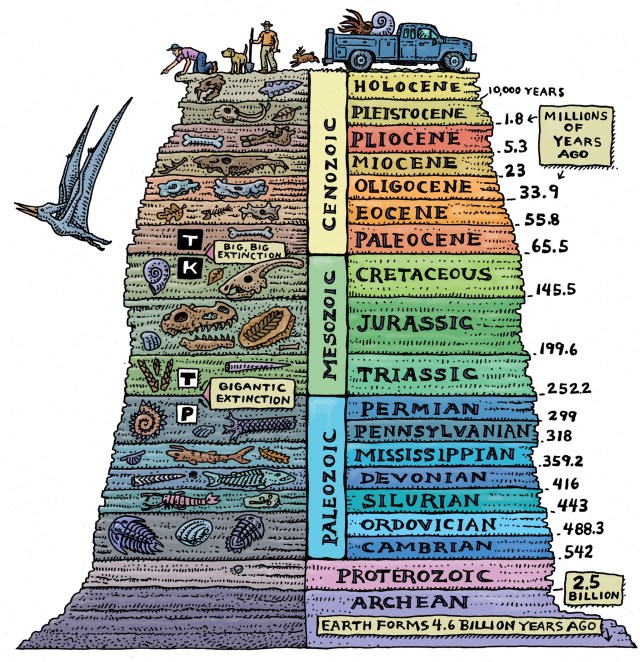
Geological Time Scale

Geological Time-scale

Historical records only go back a few thousand years, and are inadequate to treat most geological processes. To understand the timing of geological processes we need to look at the geological rock record. This includes erosion, mountain building and other geological events. Over hundreds to thousands of millions of years, continents, oceans and mountain ranges have moved vast distances both vertically and horizontally. Once-deep oceans hundreds of millions of years ago now occupy mountainous desert regions of the Earth.

How is it measured?

The earliest geological time scales simply used the order of rocks laid down in a sedimentary rock sequence (stratum) with the oldest at the bottom. However, a more powerful tool was the fossilised remains of ancient animals and plants within the rock strata. After Charles Darwin’s publication Origin of Species (Darwin himself was also a geologist) in 1859, geologists realised that particular fossils were restricted to particular layers of rock. This built up the first generalised geological time scale.

Once formations and stratigraphic sequences were mapped around the world, sequences could be matched from the faunal successions. These sequences apply from the beginning of the Cambrian period, which contains the first evidence of macro-fossils. Fossil assemblages ‘fingerprint’ formations even though some species may range through several different formations. This feature allowed William Smith (an engineer and surveyor who worked in the coal mines of England in the late 1700s) to order the fossils he started to collect in south-eastern England in 1793. He noted that different formations contained different fossils and he could map one formation from another by the differences in the fossils. As he mapped across southern England, he drew up a stratigraphic succession of rocks although they appeared in different places at different levels.

By matching similar fossils in different regions throughout the world, correlations were built up over many years. Only when radioactive isotopes were developed in the early 1900s did stratigraphic correlations become less important as igneous and metamorphic rocks could be dated for the first time.

Geological divisions

Geological Time Scale

Divisions in the geological time scales still use fossil evidence and mark major changes in the dominance of particular life forms. The Devonian Period is known as the age of fishes, as fish began to flourish at this stage. However, the end of the Devonian is marked by domination of a different life form, plants, which marks the beginning of the Carboniferous Period. The different periods can be further subdivided (e.g. Early Cambrian, Middle Cambrian and Late Cambrian).

The Precambrian Era is the time span from the beginning of the Earth at approximately 4.5 billion years ago up until 570 million years ago. It is subdivided into the Early Archaean and later Archaean and Proterozoic Eras.

The Palaeozoic Era follows the Precambrian, covering the Cambrian, Ordovician, Silurian, Devonian, Carboniferous and Permian Periods, ranging from 570 million years up to 225 million years ago.

The Mesozoic Era (covering the Triassic, Jurassic and Cretaceous Periods) spans the age range of 225 million years up to 65 million years.

The Cenozoic Era covers the last 65 million years up to the present. The Cenozoic is split into several Epochs, the Palaeocene, Eocene, Oligocene, Miocene, Pliocene, Pleistocene, and Holocene, with the Quaternary Period covering the last 2 million years.

A graphic way to represent the Eras and Periods is like a 24-hour time clock. The Precambrian Era goes from 12 midnight to 20 minutes past 10 the next evening. The time span from our earliest relatives (the Australopithecines – some 3.5 million years ago) to Homo sapiens covers less than a second on our 24 hour clock.

Terms

  • Faunal succession: is the time arrangement of fossils in the geological record.
  • Formations: are stratigraphic successions containing rocks of related geological age that formed within the same geological setting.
  • Ga: is an abbreviation used for billions (thousand million) of years ago.
  • Geochronology: is the study of the age of geological materials.
  • Ma: is an abbreviation used for millions of years ago.
  • Palaeobiology: is the study of the evolution of life during geologic time.
  • Palaeobotany: is the study of ancient plants.
  • Palaeontology: is the study of ancient lifeforms.
  • Stratigraphic succession: is a sequence of layered sedimentary rocks.

Radioactive dating

Radioactive dating is a method of dating rocks and minerals using radioactive isotopes. This method is useful for igneous and metamorphic rocks, which cannot be dated by the stratigraphic correlation method used for sedimentary rocks.

Over 300 naturally-occurring isotopes are known. Some do not change with time and form stable isotopes (i.e. those that form during chemical reactions without breaking down). The unstable or more commonly known radioactive isotopes break down by radioactive decay into other isotopes.

Radioactive decay is a natural process and comes from the atomic nucleus becoming unstable and releasing bits and pieces. These are released as radioactive particles (there are many types). This decay process leads to a more balanced nucleus and when the number of protons and neutrons balance, the atom becomes stable.

This radioactivity can be used for dating, since a radioactive ‘parent’ element decays into a stable ‘daughter’ element at a constant rate. The rate of decay (given the symbol λ) is the fraction of the ‘parent’ atoms that decay in unit time. For geological purposes, this is taken as one year. Another way of expressing this is the half-life period (given the symbol T). The half-life is the time it takes for half of the parent atoms to decay. The relationship between the two is: T = 0.693 / λ

How is it measured?

Many different radioactive isotopes and techniques are used for dating. All rely on the fact that certain elements (particularly uranium and potassium) contain a number of different isotopes whose half-life is exactly known and therefore the relative concentrations of these isotopes within a rock or mineral can measure the age. For an element to be useful for geochronology (measuring geological time), the isotope must be reasonably abundant and produce daughter isotopes at a good rate.

Either a whole rock or a single mineral grain can be dated. Some techniques place the sample in a nuclear reactor first to excite the isotopes present, then measure these isotopes using a mass spectrometer (such as in the argon-argon scheme). Others place mineral grains under a special microscope, firing a laser beam at the grains which ionises the mineral and releases the isotopes. The isotopes are then measured within the same machine by an attached mass spectrometer (an example of this is SIMS analysis).

What dating methods are there?

  • Radiocarbon (14C) dating
  • Rubidium-Strontium dating (Rb-Sr)
  • Potassium-Argon dating (K-Ar)
  • Argon-Argon dating (39Ar-40Ar)
  • Samarium-Neodymium (Sm-Nd)
  • Rhenium-Osmium (Re-Os) system
  • Uranium-Lead (U-Pb) system
  • The SHRIMP technique
  • Fission track dating

Radiocarbon (14C) dating

This is a common dating method mainly used by archaeologists as it can only date geologically recent organic materials, mainly charcoal, but also bone and antlers.

All living organisms take up carbon from their environment including a small proportion of the radioactive isotope 14C (formed from nitrogen-14 as a result of cosmic ray bombardment). The amount of carbon isotopes within living organisms reaches an equilibrium value, on death no more is taken up, and the 14C present starts to decay at a known rate. The amount of 14C present and the known rate of decay of 14C and the equilibrium value gives the length of time elapsed since the death of the organism.

This method faces problems because the cosmic ray flux has changed over time, but a calibration factor is applied to take this into account. Radiocarbon dating is normally suitable for organic materials less than 50 000 years old because beyond that time the amount of 14C becomes too small to be accurately measured.

Rubidium-Strontium dating (Rb-Sr)

This scheme was developed in 1937 but became more useful when mass spectrometers were improved in the late 1950s and early 1960s. This technique is used on ferromagnesian (iron/magnesium-containing) minerals such as micas and amphiboles or on limestones which also contain abundant strontium. However, both Rb and Sr easily follow fluids that move through rocks or escape during some types of metamorphism. This technique is less used now.

Potassium-Argon dating (K-Ar)

The dual decay of potassium (K) to 40Ar (argon) and 40Ca (calcium) was worked out between 1921 and 1942. This technique has become more widely used since the late 1950s. Its great advantage is that most rocks contain potassium, usually locked up in feldspars, clays and amphiboles. However, potassium is very mobile during metamorphism and alteration, and so this technique is not used much for old rocks, but is useful for rocks of the Mesozoic and Cenozoic Eras, particularly unaltered igneous rocks.

Argon-Argon dating (39Ar-40Ar)

This technique developed in the late 1960s but came into vogue in the early 1980s, through step-wise release of the isotopes. This technique uses the same minerals and rocks as for K-Ar dating but restricts measurements to the argon isotopic system which is not so affected by metamorphic and alteration events. It is used for very old to very young rocks.

Samarium-Neodymium (Sm-Nd)

The decay of 147Sm to 143Nd for dating rocks began in the mid-1970s and was widespread by the early 1980s. It is useful for dating very old igneous and metamorphic rocks and also meteorites and other cosmic fragments. However, there is a limited range in Sm-Nd isotopes in many igneous rocks, although metamorphic rocks that contain the mineral garnet are useful as this mineral has a large range in Sm-Nd isotopes. This technique also helps in determining the composition and evolution of the Earth’s mantle and bodies in the universe.

Rhenium-Osmium (Re-Os) system

The Re-Os isotopic system was first developed in the early 1960s, but recently has been improved for accurate age determinations. The main limitation is that it only works on certain igneous rocks as most rocks have insufficient Re and Os or lack evolution of the isotopes. This technique is good for iron meteorites and the mineral molybdenite.

Uranium-Lead (U-Pb) system

This system is highly favoured for accurate dating of igneous and metamorphic rocks, through many different techniques. It was used by the beginning of the 1900s, but took until the early 1950s to produce accurate ages of rocks. The great advantage is that almost all igneous and metamorphic rocks contain sufficient U and Pb for this dating. It can be used on powdered whole rocks, mineral concentrates (isotope dilution technique) or single grains (SHRIMP technique).

The SHRIMP technique

Zoned zircon grain

The SHRIMP (Sensitive High Resolution Ion MicroProbe) technique was developed at the Research School of Earth Sciences, Australian National University, Canberra in the early 1980s. It has revolutionised age dating using the U-Pb isotopic system. Using the SHRIMP, selected areas of growth on single grains of zircon, baddeleyite, sphene, rutile and monazite can be accurately dated (to less than 100 000 years in some cases). This technique not only dates older mineral cores (what we call inherited cores), but also later magmatic and/or metamorphic overgrowths so that it unravels the entire geological history of a single mineral grain. It can even date nonradioactive minerals when they contain inclusions of zircons and monazite, as in sapphire grains. The SHRIMP technology has now been exported to many countries such as the USA, France, Norway, Russia, Japan and China. It can help fix the maximum age of sedimentary rocks when they contain enough accessory zircon grains (usually need about 100 grains).

Because of advancements in geochronology for over 50 years, accurate formation ages are now known for many rock sequences on Earth and even in space. The oldest accurately dated rocks on Earth are metamorphosed felsic volcanic rocks from north-west Western Australia. These were dated at about 4.5 billion years old using single zircon grains on the SHRIMP.

Fission track dating

Mt Warning zircon. Photo: Geotrack International.

Several minerals incorporate tiny amounts of uranium into their structure when they crystallise. The radioactive decay from the uranium releases energy and particles (this strips away electrons leading to disorder in the mineral structure). The travel of these particles through the mineral leaves scars of damage about one thousandth of a millimetre in length. These ‘fission tracks’ are formed by the spontaneous fission of 238U and are only preserved within insulating materials where the free movement of electrons is restricted. Because the radioactive decay occurs at a known rate, the density of fission tracks for the amount of uranium within a mineral grain can be used to determine its age.

To see the fission tracks, the mineral surface is polished, etched with acids, and examined with an electron microscope. An effective way to measure the uranium concentration is to irradiate the sample in a nuclear reactor and produce comparative artificial tracks by the induced fission of 235U.

Fission track dating is commonly used on apatite, zircon and monazite. It helps to determine the rates of uplift (for geomorphology studies), subsidence rates (for petroleum exploration and sedimentary basin studies), and the age of volcanic eruptions (this is because fission tracks reset after the eruption). However, care is needed as some samples have fission tracks reset during bushfires, giving far too young ages. Fission track dating is mostly used on Cretaceous and Cenozoic rocks.

Terms

The atomic number of an element is given by the number of protons present within the element’s nucleus, and this helps determine the chemical properties of that element.

The atomic mass of an element combines the number of protons and neutrons within its nucleus.

The atomic weight of an element is the average relative weight (mass) of atoms and can vary to give different isotopic members of the element.Isotopes are atoms with the same atomic number (i.e. protons) and have different atomic masses (i.e. number of neutrons).

For example, the element potassium (represented by the symbol K) has three isotopes:

Isotope 39 K 40 K 41 K
Relative abundance in nature 93.1% 0.01% 6.9%

The numbers 39, 40, and 41 are the mass numbers. As all three isotopes have 19 protons, they all have the chemical properties of potassium, but the number of neutrons differs: 20 in 39K, 21 in 40K, and 22 in 41K. Potassium has an atomic weight of 39.102, close to the mass (39) of its most abundant isotope in nature (39K).

References

Dickin, A.P., 2000. Radiogenic isotope geology. Cambridge University Press, 490p.

York, D., and Farquhar, R.M., 1972. The Earth’s age and geochronology. Pergamon Press Ltd, 178p.

Links

dig deeper

Posted in Archaeology, interior of the Earth, Physical geography | 1 Comment

Coral Reefs are the “Rainforests” of the ocean

Coral Reefs are the “Rainforests” of the ocean. Reefs are ecologically important ecosystems and have a high biodiversity that serves as a storage bank of rich genetic resources. They are a source of food and medicine, and they protect the coast from wave erosion.

Corals are marine animals related to jellyfish and anemones. Both colonial and solitary corals catch plankton (microscopic plants and animals) and other suspended food particles with arm-like tentacles, which feed a centrally located mouth. Most hard corals also host symbiotic algae, a long-standing and successful partnership. These algae provide them with an additional food source through photosynthesis. Coral reefs are formed by corals that secrete hard calcareous (aragonite) exoskeletons, giving them structural rigidity. These colonial “hard corals” form elaborate finger-shaped, branching, or moundshaped structures and can create masses of limestone that stretch for tens or even hundreds of miles.

Although corals have a wide distribution in the world’s oceans, the varieties that form reefs are typically restricted to relatively shallow, warm tropical waters between latitudes 30° north and 30° south. Clean, clear water is essential to their health. Once coral larvae settle on a hard substrate and become established, colonies can arise if conditions are suitable for growth. Given enough time, coral colonies become thickets. As coral thickets build upward on the skeletal remains of older colonies, a reef is established. Today, richly diverse coral reefs are found in the tropics along coastlines, on the margins of volcanic islands, and as isolated coral atolls.

coral reef map

There are two distinct regions in which coral reefs are primarily distributed: the Wider Caribbean (Atlantic Ocean) and the Indo-Pacific (from East Africa and the Red Sea to the Central Pacific Ocean).

coral reef coral reef coral reef coral reef

  • The diversity of coral is far greater in the Indo-Pacific, particularly around Indonesia, the Philippines, and Papua New Guinea. Many other groups of marine fauna show similar patterns, with a much greater diversity in the Indo-Pacific region.
  • Although they possess a smaller number of species the corals of the Atlantic are still unique, with few common species between the two regions .

coral reef map

The majority of reef building corals are found within tropical and subtropical waters. These typically occur between 300 north and 300 south latitudes. The red dots on this map show the location of major stony coral reefs of the world. Credit:NOAA

Coral reefs are found in about 100 countries. Coral Reefs are home to over 25 percent of all marine life and are among the world’s most fragile and endangered ecosystems. In the last few decades over 35 million acres of Coral Reefs have been obliterated. Reefs off of 93 countries have been damaged . When corals are stressed by high temperature, ultraviolet light or other environmental changes, they lose their symbiotic algal cells, and appear white (the white skeleton is actually visible through the transparent tissue). Depending on the intensity and duration of the stress, the corals may recover or die.

Tarawa, Kiribati

NOAA Image

If the present rate of destruction continues, 70% of the world’s coral reefs will be destroyed within the next few decades.

Coral Bleaching

Climate change will destroy the world’s great coral reefs within a century, according to a report by German and Australian marine scientists.Researchers say governments must take action now to reduce the emissions of gases such as carbon dioxide, which are thought to be behind a rise in average global temperatures.

bleached coral reef
A slight rise in temperature can bleach coral like this

The scientists combined their coral expertise with the latest climate models to project what is likely to happen to the world’s greatest reefs if global warming remains unchecked. Their study suggests the unique marine environments will increasingly become victim to a process known as coral bleaching.

A slight rise in maximum water temperatures – only one to two degrees – can stress the corals. This causes them to expel the microscopic organisms, known as zooxanthellae, which color their tissues and provide them with essential nutrients.

If the zooxanthellae do not return, the corals will die. In 1998 every reef system in the world’s tropical oceans were affected by some degree of bleaching. The report says the frequency and intensity of bleaching is set to rise.

The report’s lead author is Professor Ove Hoegh-Guldberg, an expert on coral bleaching at Sydney University. Coral reefs could be eliminated from most areas of the world by 2100, Even the world’s largest reef – the Great Barrier Reef off Australia – could be dead within 30 years unless measures are taken now to slow climate change.

Coral Reef Bleaching

What are Corals?

NOAA Image

Coral is a general term used to describe a group of cnidarians, which indicates the presence of skeletal material that is embedded in the living tissue or encloses the animal altogether. -National Oceanic and Atmospheric Administration, U.S. Dept. of Commerce. “Glossary of Coral Reef Terminology.”

NOAA Image

Corals themselves are tiny animals which belong to the group cnidaria (the “c” is silent). Other cnidarians include hydras, jellyfish, and sea anemones. Corals are sessile animals, meaning they are not mobile but stay fixed in one place.They feed by reaching out with tentacles to catch prey such as small fish and planktonic animals.

Corals are anthozoans, the largest class of organisms within the phylum Cnidaria. Comprising over 6,000 known species, anthozoans also include sea fans, sea pansies and anemones. Stony corals (scleractinians) make up the largest order of anthozoans, and are the group primarily responsible for laying the foundations of, and building up, reef structures. For the most part, scleractinians are colonial organisms composed of hundreds to hundreds of thousands of individuals, called polyps.


Corals live in colonies consisting of many individuals, each of which is called polyp. They secrete a hard calcium carbonate skeleton, which serves as a uniform base or substrate for the colony. The skeleton also provides protection, as the polyps can contract into the structure if predators approach. It is these hard skeletal structures that build up coral reefs over time. The calcium carbonate is secreted at the base of the polyps, so the living coral colony occurs at the surface of the skeletal structure, completely covering it. Calcium carbonate is continuously deposited by the living colony, adding to the size of the structure. Growth of these structures varies greatly, depending on the species of coral and environmental conditions– ranging from 0.3 to 10 centimeters per year. Different species of coral build structures of various sizes and shapes (“brain corals,” “fan corals,” etc.), creating amazing diversity and complexity in the coral reef ecosystem. Various coral species tend to be segregated into characteristic zones on a reef, separated out by competition with other species and by environmental conditions.


coral reef polyps

Most corals are made up of hundreds of thousands individual polyps like this one. Many stony coral polyps range in size from one to three millimeters in diameter. Anatomically simple organisms, much of the polyp’s body is taken up by a stomach filled with digestive filaments. Open at only one end, the polyp takes in food and expels waste through its mouth. A ring of tentacles surrounding the mouth aids in capturing food, expelling waste and clearing away debris. Most food is captured with the help of special stinging cells called nematocysts which are inside the polyp’ outer tissues, which is called the epidermis. Calcium carbonate is secreted by reef-building polyps and forms a protective cup called a calyx within which the polyps sits. The base of the calyx upon which the polyp sits is called the basal plate. The walls surrounding the calyx are called the theca. The coenosarc is a thin band of living tissue that connect individual polyps to one another and help make it a colonial organism.

As members of the phylum Cnidaria, corals have only a limited degree of organ development. Each polyp consists of three basic tissue layers: an outer epidermis, an inner layer of cells lining the gastrovascular cavity which acts as an internal space for digestion, and a layer called the mesoglea in between

coral reef


The diagram above shows the anatomy of a nematocyst cell and its “firing” sequence, from left to right. On the far left is a nematocyst inside its cellular capsule. The cell’s thread is coiled under pressure and wrapped around a stinging barb. When potential prey makes contact with the tentacles of a polyp, the nematocyst cell is stimulated. This causes a flap of tissue covering the nematocyst—the operculum—to fly open. The middle image shows the open operculum, the rapidly uncoiling thread and the emerging barb. On the far right is the fully extended cell. The barbs at the end of the nematocyst are designed to stick into the polyp’s victim and inject a poisonous liquid. When subdued, the polyp’s tentacles move the prey toward its mouth and the nematocysts recoil back into their capsules.


All coral polyps share two basic structural features with other members of their phylum. The first is a gastrovascular cavity that opens at only one end. At the opening to this cavity, commonly called the mouth, food is consumed and some waste products are expelled. A second feature all corals possess is a circle of tentacles, extensions of the body wall that surround the mouth. Tentacles help the coral to capture and ingest plankton for food, clear away debris from the mouth, and act as the animal’s primary means of defense.

coral polyps

coral polyps

Credit:University of Texas

While coral polyps have structurally simple body plans, they possess several distinctive cellular structures. One of these is called a cnidocyte—a type of cell unique to, and characteristic of, all cnidarians. Found throughout the tentacles and epidermis, cnidocytes contain organelles called cnidae, which include nematocysts, a type of stinging cell. Because nematocytes are capable of delivering powerful, often lethal toxins, they are essential to capturing prey, and facilitate coralline agonistic interactions

Most corals, like other cnidarians, contain a symbiotic algae called zooxanthellae, within their gastrodermal cells. The coral provides the algae with a protected environment and the compounds necessary for photosynthesis. These include carbon dioxide, produced by coral respiration, and inorganic nutrients such as nitrates, and phosphates, which are metabolic waste products of the coral. In return, the algae produce oxygen and help the coral to remove wastes. Most importantly, they supply the coral with organic products of photosynthesis. These compounds, including glucose, glycerol, and amino acids, are utilized by the coral as building blocks in the manufacture of proteins, fats, and carbohydrates, as well as the synthesis of calcium carbonate (CaCO3). The mutual exchange of algal photosynthates and cnidarian metabolites is the key to the prodigious biological productivity and limestone-secreting capacity of reef building corals.

Zooxanthellae

(Courtesy Scott R. Santos, of the State University of New York at Buffalo)

Zooxanthellae often are critical elements in the continuing health of reef-building corals. As much as 90% of the organic material they manufacture photosynthetically is transferred to the host coral tissue . If these algal cells are expelled by the polyps, which can occur if the colony undergoes prolonged physiological stress, the host may die shortly afterwards. The symbiotic zooxanthellae also confers its color to the polyp. If the zooxanthellae are expelled, the colony takes on a stark white appearance, which is commonly described as “coral bleaching”

Coral Reef Facts

  • Fact: Coral reefs are among the oldest ecosystems on Earth.
  • Fact: Coral reefs are the largest living structure on the planet.
  • Fact: Although coral reefs cover less than 1% of the Earth’s surface, they are home to 25% of all marine fish species.
  • Fact: 500 million people rely on coral reefs for their food and livelihoods.
  • Fact: Coral reefs form natural barriers that protect nearby shorelines from the eroding forces of the sea, thereby protecting coastal dwellings, agricultural land and beaches.
  • Fact: Without the existence of coral reefs, parts of Florida would be under water.
  • Fact: Coral reefs have been used in the treatment of cancer, HIV, cardiovascular diseases and ulcers.
  • Fact: Corals’ porous limestone skeletons have been used for human bone grafts.
  • Fact: It is estimated that coral reefs provide $375 billion per year around the world in goods and services.
  • Fact: If the present rate of destruction continues, 70% of the world’s coral reefs will be destroyed by the year 2050.


<!–

How Can You Help Save Coral Reefs?

This year, help us rescue the coral reefs of Indonesia — located in the heart of the Coral Triangle. The seas surrounding this archipelago contain the world’s highest fish and coral diversity. Indonesia’s waters are also home to whales, dolphins, dugongs and sea turtles.

However, threats such as destructive fishing practices and coastal development are straining marine resources beyond sustainable levels. With your help, we can protect Indonesia’s beautiful seascapes, have a lasting impact on conservation and Rescue the Reef!

–>

Related Readings:

Types of Coral Reefs-Click Here


source:http://www.solcomhouse.com

Posted in oceans | Tagged , , | 7 Comments

Structure and composition of the Earth

What makes Earth unique?

Soon after the Earth formed, unique processes occurred – division into metallic core, silicate mantle and crust – which, along with surface water, made it different from the other planets in our Solar System. The formation of the early mantle was important as it consisted primarily of ferromagnesium silicate minerals, some of which contained water as an essential component (e.g. amphibole group minerals). Water-bearing magmas (molten rock) from deep in the lower mantle then rose towards the surface (being liquid, they were lighter than the surrounding solid rock) and emerged as volcanic eruptions.

The Earth’s atmosphere and hydrosphere developed from the degassing (loss of gaseous elements such as carbon, hydrogen and oxygen) of the early-formed core and mantle during this volcanic activity. In the present, abundant gases are still released from the Earth during volcanic eruptions and these are mainly composed of water (77%), carbon dioxide (12%), sulfur dioxide (7%), and nitrogen (3%), with minor amounts of hydrogen, carbon monoxide, sulfur, chlorine and argon.

The Earth can be divided into two main parts.

  • atmosphere: measured from the surface of the Earth upwards to 150 km (anything above this is called space)
  • solid Earth: measured from the surface of the Earth downwards to the core

The atmosphere

The atmosphere makes up less than one millionth of the total mass of the Earth, and contains mainly nitrogen and oxygen (99% of the total) as gases. Other important components of the atmosphere are hydrogen, carbon dioxide, and inert gases such as argon and helium.

The Earth’s atmosphere and climate have changed since the Earth first formed more than four billion years ago. We know this from the geological record of the earliest known sedimentary rocks which could only have been deposited in water. Water boils above 100° C under normal atmospheric conditions. The presence of these early sedimentary rocks indicates that by four billion years ago, the surface temperature of the Earth must have cooled below 100° C. Also, some of these early sedimentary rocks are carbonate rocks (mainly dolomitic), indicating these rocks were formed in water that contained dissolved bicarbonate ions. The early atmosphere of the Earth must have contained more carbon dioxide than today’s atmosphere. Currently, the early atmosphere is understood to have consisted of nitrogen, carbon dioxide, carbon monoxide, water and hydrogen.

The atmosphere is divided (measured from the surface of the Earth) into:

  • Troposphere (0 km – 13 km)
  • Ozone Layer (13 km – 25 km)
  • Stratosphere (25 km – 50 km)
  • Mesosphere (50 km – 75 km)
  • Thermosphere (75 km – 150 km)

The solid Earth

This can be divided into the:

  • Biosphere (water, organic substances and skeletal matter) – solid and liquid – and includes all forms of life (e.g. plants and animals) and their products (e.g. skeletons) both on land and in the sea
  • Hydrosphere (fresh and salt water, snow and ice) – mainly liquid, some solid – includes all forms of water
  • Internal structure of the Earth, which includes:
    • Crust (normal silicate rocks such as granite and basalt) – solid
    • Mantle (ferromagnesium-rich silicate rocks) – solid
    • Core (iron-nickel alloy) – liquid upper part and solid lower part


Although geologists generally don’t study the atmosphere, biosphere or hydrosphere, all three are vitally important in understanding geological processes, particularly weathering and erosion, and the formation of many sedimentary rocks (e.g. formation of coral reefs in shallow warm seas).

Looking inside the Earth

The internal structure of the Earth consists of three main parts, the crust, mantle and core. The division between the crust and the mantle is called the Moho.

  • The crust
  • The Moho
  • The mantle
  • The core

The crust

The crust makes up only 0.5 % of the Earth’s total mass and can be subdivided into two main parts, continental and oceanic. Both differ in thickness, density and composition. Although oceanic crust covers approximately 61 % of the Earth’s surface, it only comprises some 30 % of the crustal mass, as the continental crust is much thicker.

Continental crust: from the surface of the Earth down to 30 km – 50 km. The exposed parts of the continental crust are less dense than oceanic crust (this is because oceanic crust contains minerals rich in heavier elements such as iron and magnesium). However, continental crust appears to be stratified (layered) and becomes denser with depth. It is largely composed of volcanic, sedimentary and granitic rocks, although the older areas are dominated by metamorphic rocks. The continental crust can be divided into:

  1. Stable continental regions (e.g. Precambrian cratons, platforms of undeformed sediments on crystalline basements)
    Thickness: 35 km – 45 km
    Density: 2.69 gm/cm3 – 2.74 gm/cm3 for the upper crust and 3.0 gm/cm3 – 3.25 gm/cm3 for the lower crust.
    Composition

    • Upper Crust (sial): felsic igneous and metamorphic rocks. Average composition close to that of either a mafic granodiorite or quartz diorite.
    • Lower Crust (sima): anhydrous (no water) – quartz andesite or andesite; hydrous – amphibolite or diorite
  2. Tectonically active regions (e.g. the Andes, Himalayas)
    Thickness: 55 km – 70 km
    Composition: varies from region to region but may consist of any of the following:

    1. mafic rocks
    2. amphibolites
    3. ultramafic, mafic and felsic-intermediate rocks

Oceanic crust: from the surface of the Earth down to 10 km – 12 km. The oceanic crust can be divided into:

  1. Ocean basins: water depth exceeds 4 km, layered and very uniform and consists of three distinctive layers:
    • Layer 1: thickness of < 1 km; deep water sediments in various stages of lithification (turning into rock), commonly foraminiferal ooze, chert and mudstone.
    • Layer 2: thickness of 1.6 km – 2 km; basalts and dolerites with pillow lavas, dykes and sills (i.e. volcanic extrusive and intrusive rocks).
    • Layer 3: thickness of 3.0 km – 5.7 km; the main crustal layer; dolerite, gabbro and amphibolite (i.e. intrusive mafic rocks).
    • Layer 3B: thickness is variable but up to 3 km; not always present; metagabbros and pyroxenites (i.e. intrusive mafic and ultramafic rocks).
  2. Mid-ocean ridges
    In mid-ocean ridges (such as the Mid-Atlantic Ridge), Layer 1 is absent; Layer 2 crops out on the surface and is thicker than normal; Layer 3 is thinner than normal and passes transitionally into the upper mantle.
  3. Island arcs
    The structure beneath island arcs (such as the Indonesian Arc) is very complex and the composition of the crust in these regions is very heterogenous. The most common rocktypes in surface exposures are volcanic andesites (from explosive volcanoes) and deep-sea sediments.

The Moho

The boundary between the crust and mantle is known as the Mohorovicic Discontinuity (Moho). It marks a significant change in chemical composition and is the boundary between the crust and mantle. It is a sharp boundary at which both P- and S-wave speeds rise from crustal to higher values. This change occurs over a distance of 0.1 km to 0.5 km in oceanic and stable continental regions. In tectonically active regions, the change is far more gradual and generally ill-defined – in many cases, there may not even be a Moho. At present there are two main hypotheses for what the Moho represents:
  • a phase transition: The Moho may mark an isochemical phase transformation (i.e. change in mineralogy but not chemistry) from a gabbroic lower crust to an eclogitic upper mantle. However, this phase transformation appears to be a gradual process in oceanic and stable continental regions.
  • a chemical discontinuity: The most widely accepted theory for the Moho is that it represents a chemical change from intermediate and mafic crustal rocks, to an ultramafic mantle.

The mantle

The mantle is thought to be primarily composed of ultrabasic rocks (rocks rich in magnesium and iron, and poor in silica; mostly peridotites). As seismic velocity change through the mantle, we can subdivide it into an upper mantle, transition zone, and lower mantle. There is also a zone in the upper mantle that we call the low velocity zone (located at depths of 70 km to 250 km) where S-wave speeds decrease rapidly to a minimum and then gradually increase again. We believe that most magmas (molten rock) are generated in this zone.

Upper mantle (measured from the base of the crust down to 400 km). 10 % of the Earth’s total mass.

  • Density of 3.25 gm/cm3 to 3.40 gm/cm3
  • Composition: Peridotite (e.g. olivine + pyroxene) along with plagioclase (< 30 km depth), spinel (30 km – 70 km depth) and garnet (> 70 km depth). In tectonically active regions, eclogite (amphibole + garnet) is a major component. Although it is thought that almost all basalts are derived from the upper mantle, experiments have shown that their compositions cannot be formed by the partial melting of peridotite alone. The upper mantle therefore is probably composed of two main zones: an upper peridotite zone and an underlying primitive mantle or pyrolite zone composed of pyroxene, olivine, and/or garnet and/or plagioclase, where basaltic magmas are generated.
  • The pyrolite model: was first proposed by two Australian geoscientists, Green and Ringwood (1963), in order to explain the nature of the composition of the upper mantle. They recognised that most mantle xenoliths had previously undergone some partial melting in order to produce basaltic magmas. They suggested that a model composition of the undepleted upper mantle could be tested by experimental methods to determine the types of basaltic magmas that were produced. They made this by mixing three parts dunite (olivine-rich) with one part basalt (pyroxene and feldspar rich) and called this mixture pyrolite (pyroxene-olivine). Experimental melting studies on this mixture at differing values of pressure, temperature and volatile content has yielded the range of most known basalt compositions suggesting that it is a valid model for the composition of the upper mantle.

Transition zone (400 km – 1000 km below the Earth’s surface). 17 % of the Earth’s total mass.

  • The top of the transition zone is marked by the phase transformation of normal olivine to a proto-spinel structure polymorph of olivine which is a higher pressure phase and is 9 % denser than normal olivine and by the phase transformation of normal pyroxene to a garnet-structure polymorph of pyroxene. Within the transition zone itself, there are a number of irregular seismic velocity changes including a major one at 680 km which is marked by the breakdown of olivine into its constituent oxide components of periclase (MgO) and stishovite (SiO2). Also, garnet is broken-down to its component oxides from 680 km – 1000 km.

Lower mantle (1000 km – 2900 km below the Earth’s surface). 41 % of the Earth’s total mass.

  • The lower mantle is a region of relatively low seismic velocity gradients. It most likely consists of mixed oxides of pyrolite composition but with an increased iron content.

The core

The core is marked as that point within the Earth where S-waves cannot penetrate. It is believed to be composed primarily of a nickel-iron alloy (along with abundant platinum-group elements), consisting of a liquid outer zone, and a solid inner zone. It is also marked by an abrupt increase in pressure.

  • Outer core (2900 km – 5000 km below the Earth’s surface). 30 % of the Earth’s total mass.
  • Inner core (5000 km – 6370 km below the Earth’s surface). 2 % of the Earth’s total mass.

Chemical composition of the Earth

The overall composition of the Earth is dominated by the elements iron (Fe), oxygen (O), silicon (Si), magnesium (Mg), nickel (Ni) and sulfur (S). This is because most of the mass of the Earth occurs within the mantle which is composed largely of the ferromagnesium silicate minerals olivine and pyroxenes. The core of the Earth is largely composed of iron and nickel. The crust of the Earth mainly comprises the minerals plagioclase, quartz and hornblende and is dominated by the elements oxygen, silicon, aluminium, iron, calcium, sodium, and potassium.

The overall composition of the Earth is very similar to that of meteorites, and because of this, it is thought that the Earth originally formed from Planetesimals composed largely of metallic iron and silicates.

P- and S-waves

Seismology is the study of the origin and propagation of elastic waves through planetary bodies. It was originally regarded as the study of earthquakes. The subdivisions in the Earth’s interior are marked by abrupt changes in seismic velocities at specific depths. The two types of seismic wave relevant to studying the Earth’s interior are:
  • P-waves: Primary or Compressional Waves are the fastest type of wave and have velocities of 5 km/s at the top of the crust, 8 km/s at the top of the mantle, and 14 km/s at the bottom of the mantle. P-waves can travel through solids and liquids, so they can travel through the Earth’s core (the outer core is liquid).
  • S-waves: Shear or Transverse waves that travel at slower speeds than P-waves. They can only travel through solids, so they do not travel through the Earth’s core.

source

Posted in interior of the Earth | 1 Comment

Magmatic processes and igneous intrusions


Magma

  • What is magma?
  • Properties of magmas
  • Chemical composition

What is magma?

Magma is hot molten mobile rock. Igneous rocks form when magma cools and solidifies. Magmas come out of active volcanoes as lavas. The most abundant magma is a melt of silicate composition and this can carry suspended crystals and gases which bubble out in air.

Magmas consolidate at the surface as lava flows (volcanic), or fall as lithic (rock), crystal and/or glass fragments (pyroclastic). Some solidify within the earth (plutonic or subvolcanic rocks).

Properties of magmas

The properties of magmas include:

  • Temperature
  • Density
  • Viscosity
  • Gas content
  • Abundance

Temperature

The temperature of a magma is hard to measure. It can be done at a distance using an optical pyrometer (glowing filament) but this needs many corrections (e.g. for air temperature, distance, and elevation). The temperature of some lavas can be measured in the field using a thermocouple providing the eruption is not violent (as in lava flows or lakes).

Less silica-rich lavas generally come out at 1000° C – 1230° C while silica-rich lavas are cooler at 750° C – 900° C. Komatiitic lavas (very rich in magnesium and low in silica) probably erupted at 1300° C – 1400° C and mostly date from the Archean Era when the earth was hotter.

Density

The density of chilled magma (volcanic glass) is usually measured. It ranges from 2.4 g/cm3 (for silica-rich lavas) to 2.9 g/cm3 (for silica-poor lavas).

Viscosity

Viscosity is the resistance of a fluid to motion. For example, syrup is more viscous than water. The viscosity of a silicate melt (liquid magma) is controlled by its degree of structure, with increased structure in magmas correlating strongly with increased viscosity. Although silica-rich magmas have lower temperatures than silica-poor magmas, a high degree structure gives them higher viscosity. Rises in temperature and in water content break down the structure of magmas and decrease their viscosity. Therefore, a water-rich magma is more fluid than a dry magma of the same composition.

Many melts are rich in basic oxides such as MgO and FeO and relatively low in silica. The silicate structures that develop favour the crystallisation of minerals of the olivine and pyroxene groups (i.e. simple silicate structures). Conversely, silica-rich melts favour the crystallisation of silicates such as feldspars, micas and quartz (i.e. more complex silicate structures).

Gas content

Many lavas are vesicular (have cavities), indicating former gas bubbles which escaped from within the magma as it erupted at the surface. Some 99% of all gases in lavas are water vapour. Other gases that bubble out at the surface include nitrogen, oxygen, argon, carbon dioxide, boron, carbon monoxide, methane, hydrogen, nitric acid, hydrochloric acid, hydrofluoric acid, sulfuric acid, sulfur dioxide and sulfur trioxide. In some lava lakes, gases come out as invisible, colourless and odourless gas bursts and may kill many people and animals.

Abundance

The most common igneous rocks by far are granites and basalts. Granites (containing around >15% quartz, and more alkali feldspar than plagioclase feldspar) form >95 % of all igneous plutonic rocks, while basalts form >98 % of all volcanic rocks.

Chemical composition

As magma erupted at the surface is difficult to sample, the solid rocks that form after cooling provide us with the most information on the chemistry of magmas. Most contain silicate minerals (in which Si, Al, Mg, Fe, Ca, Na and K combine with oxygen) and some minor oxide minerals. These rocks are made up of:

  • Major elements: Oxides that account for >98% of the chemical composition of all igneous rocks, including: SiO2 (35 – 75%), Al2O3 (12 – 18%), FeO+Fe2O3 +MgO+CaO (20 – 30%). Also, Na2O (2.5 – 4%) and K2O (0.5 – 5%) tend to increase with SiO2 content.
  • Minor elements: TiO2, MnO, H2O and P2O5 usually make up between 0.1 and 1%.
  • Trace elements: The remaining elements (<0.1%), which are usually reported as parts per million (ppm) (1 ppm = 1 gram per ton).

Igneous Intrusions

  • What are intrusions?
  • Types of intrusions

What are intrusions?

Molten magma can invade the Earth’s upper layers and then solidify. Gravity influences the emplacement of igneous rocks because it acts on the density differences between the magma and surrounding wallrocks (country rocks). In general, silica-rich magmas are less dense than wallrocks, while silica-poor magmas are similar in density to wallrocks. Because of this, lower density intrusions take different shapes to higher density intrusions.

Low-density magmas (such as granitic magmas) are more buoyant in their invasions and cause subsidence of the surrounding wallrocks. High-density magmas (such as basaltic magmas) are closer in hydrostatic equilibrium with the surrounding wallrocks.

Types of intrusions

  • Dykes
  • Silica-rich intrusions
  • Silica-poor intrusions
Dykes

Dykes are sheet-like bodies of igneous rock that cut across sedimentary bedding or foliations in rocks. They may be single or multiple in nature. Dykes often have a fine-grained margin where they were chilled rapidly against the wallrocks. Small dykes tend to be fine-grained while large dykes tend to be coarser grained.

Silica-rich intrusions

Silica-rich intrusions include:

  • Stoped stocks
  • Ring dykes and bell-jar plutons
  • Centred complexes
  • Sheeted intrusions
  • Diapiric plutons
  • Batholiths
Matic xenolith in granite
Matic xenolith in granite, Duckmaloi, New South Wales. Photo: I Graham © Australian Museum.
Stoped stocks

Stoping happens when a rising magma breaks off jointed blocks from the overlying country rock. The magma forces its way into the cracked roof and fragments of the wallrock sink into the magma. These fragments within the magmatic rock are known as xenoliths and can range in size from less than a millimetre up to tens of kilometres. The xenolith-rich Corralillo granodiorite of Peru is a good example, where xenoliths are concentrated near the roof of the intrusions (roof pendants) but become smaller and more rounded when digested further within the intrusion.

In the Thorr granodioritic pluton of Donegal, Ireland many of the xenoliths are large (several hundred metres) and their origin (e.g. limestone, schist) is still recognisable and can be correlated with the surrounding rock structures. This means there was little movement in the xenoliths after they were incorporated from their parent rocks.

Ring dykes and bell-jar plutons

Ring dykes form a cylinder around a subsided block of country rock, fill ing the ring-shaped fracture with magma. Excellent examples of ring dykes are seen on the island of Mull, Scotland. Large subsidence of a core of country rock can also form a circular pluton in the shape of a bell-jar.

Centred complexes

In composite intrusions, some are arranged in concentric rings. These often formed as rings of intrusion spread outwards from a focus. These are called centred complexes.

Sheeted intrusions

Some intrusions form relatively flat-lying sheets, often with an undulating surface.

Diapiric plutons

Diapirs are circular-shaped intrusions with vertical walls that force their way into place, strongly deforming the surrounding country rocks. The diapirs probably rose as buoyant magma, forcing their way up and through the denser country rocks. Diapirs are generally unfoliated (unbanded) in their centre. They become more foliated (banded) towards the contact with the country rocks, where numerous xenoliths have become more flattened. The foliation and flattening of the xenoliths runs parallel to this contact. The adjacent surrounding country rocks are intensely deformed and stretched out parallel to the intrusion.

Granite country near Pyalong, Victoria
Granite country near Pyalong, Victoria. Photo: I Graham © Australian Museum.
Batholiths

In many parts of the world, granites extend for many hundreds of kilometres in large masses called batholiths. These are not single intrusions but usually composite intrusions of similar magmas. The individual plutons in batholiths vary in size but the largest are about 30 km across. The individual plutons can show quite different forms and ages of emplacement (sometimes separated by millions of years). At the surface, granites in batholiths often weather and erode into rounded masses called tors.

The massive batholiths represent repeated and voluminous production of magmas during a period of plate tectonic activity. An excellent example is the Berridale Batholith of the Snowy Mountains, New South Wales.

Silica-poor intrusions

These denser magmas crystallise into several different shapes:

  • Flat-lying sheets
  • Laccoliths
  • Cone sheets
  • Funnel-shaped intrusions
  • Funnel dykes
  • Lopoliths
  • Dyke swarms
  • Diatremes
Flat-lying sheets

Flat-lying sheets (sills) range in size from less than a metre thick up to huge intrusions underlying thousands of square kilometres. The Whin Sill of northern England is up to 100 m thick and intrudes an area of over 5000 square kilometres. Although sills typically intrude along the surrounding rock layers, almost all large sills vary in thickness and transgress into higher layers when mapped over a large area. These transgressions can occur as abrupt steps. The dolerite sills of the Karoo South Africa, the Transantarctic mountains and Tasmania occur as undulating discordant sheets.

Laccoliths

Laccoliths are lens-shaped intrusions where magmas were emplaced like a sill between sedimentary layers but then bulged up into a dome. This commonly happens in dioritic intrusions. An excellent example of a laccolith is the Prospect intrusion of Sydney, New South Wales.

Cone sheets

Cones are thin intrusive sheets that expand upwards and outwards in cones. Individual sheets are generally a few metres thick, but arranged so that the outer cones dip at lower angles to the inner ones so that they all converge towards a common source at depth.

Funnel-shaped intrusions

These have a much thicker top that plunges down to a very narrow neck. A classic example is the Skaergaard intrusion of Greenland.

Funnel dykes

Funnel dykes are elongated in outcrop like a dyke but with a V-shaped cross-section that narrows downwards. All known examples are very large (over 100 km in length). The Great Dyke of Zimbabwe is over 700 km long and the Jimberlana dyke of Western Australia is over 180 km long.

Lopoliths

Lopoliths are the largest known intrusions of dense magma and form a thick saucer shape within the surrounding country rocks. A famous example is the Bushveld Complex of South Africa, which is over 550 km across and up to 8 km in thickness. Lopoliths contain many important economic deposits of nickel, copper, platinum, palladium and chromium. The Sudbury intrusion of Ontario, Canada formed in an oval-shaped depression probably caused by a large meteorite impact.

Dyke swarms

Dykes reach their highest numbers in dyke swarms, which may form lines or radial patterns. Radial dykes usually converge on volcanic centres or igneous intrusions. Linear dyke swarms are more extensive than radial dyke swarms but can also be concentrated around large intrusions or volcanic centres. In south-eastern Iceland, the Cenozoic lava succession is cut by thousands of aligned near-vertical basaltic dykes averaging less than a metre thick.

Diatremes

Diatremes are steep pipe-like bodies filled with fragments of both igneous rocks and wallrocks. They form by explosion which results from the release of contained carbon dioxide gas (CO2) and water vapour (H2O) near the surface. Some very silica-poor magma types are economically important as the host rocks for diamonds.

source:http://www.austmus.gov.au

Posted in earth, Earth Magnetism, interior of the Earth, Landforms, Volcanoes | Leave a comment