Contours: An Overview

  • Contour –  Contour is an imaginary line on ground joining points of equal or constant elevations. contours are important to draw the topographical maps in which vertical distances are also shown using the contour lines.
  • Contour interval: Vertical distance between any two consecutive contours is known as the contour interval. It depends upon the scale of the map, nature of the ground and availability of the fund  and time.
  • Horizontal equivalent/ horizontal interval:  It is the shortest horizontal distance between the two consecutive contours.
  • Contour Gradient: Imaginary line on the surface of the earth, maintains a constant angle to the horizontal.
Characteristics of the contours:


  1. When contours are drawn closer to each other, it shows a steep slope on the ground and when they are far apart it shows the gentle slope on the ground.
  2.  When they are parallel straight and equivalent they represent a plane surface.
  3. A contour is perpendicular to a line of the steepest slope.
  4. A contour must close itself in the map or must go out of the boundaries of the map.
  5. A set of ring contours with higher values of contour inside and lower values outside represents a hill and if the higher values are outside and lower values inside then it represents a depression like a pond.
  6. When contours cross a ridge they form a V- shape across them. While if they cross a valley they form a u-shape or may a V shape also difference being, the concavity of the contour lines lies towards the lower contours in case of valley while it is convexity lying towards the another lower value in case of contours of a ridge.
  7. Contour lines must close, not necessarily in the limits of the plan.
  8. The horizontal distance between any two contour lines indicates the amount of slope and varies inversely on the amount of slope.
  9. Widely spaced contour indicates flat surface.
  10. Closely situated contour indicates steep slope ground.
    contour showing steep slope terrain
    contour showing steep slope terrain
  11. Equally spaced contour indicates uniform slope.
    contour showing uniform slope terrain
    contour showing uniform slope terrain
  12. Irregular contours indicate uneven surface.
  13. Approximately concentric closed contours with decreasing values towards centre indicate a pond.
    Pond and its contour
    Pond and its contour
  14. Approximately concentric closed contours with increasing values towards centre indicate hills.
    Hill and its contour
    Hill and its contour
  15. Contour lines with U-shape with convexity towards lower ground indicate ridge.
  16. Contour lines with V-shaped with convexity towards higher ground indicate valley.
    contour showing ridge line and valley line
    contour showing ridge line and valley line
  17. Contour lines generally do not meet or intersect each other. If contour lines are meeting in some portion, it shows existence of a vertical  cliff.
    Vertical cliff and its contour
    Vertical cliff and its contour
  18. Contours of different elevations cannot cross each other. If contour lines cross each other, it shows existence of overhanging cliffs or a cave.
    overhanging cliff and its contour
    overhanging cliff and its contour
  19. The steepest slope of terrain at any point on a contour is represented along the normal of the contour at that point.
  20. Contours do not pass through permanent structures such as buildings.
    contour across a permanent structure
    contour across a permanent structure
Uses of Contours:
  1. To study the general character of the tract of the country without visiting the ground. With the knowledge of characteristics of contours, it is easy to visualize whether country is flat, undulating or mountainous.
  2. To decide the sites for engineering works such as reservoirs, canals, roads and railways etc. on the basis of the economy.
  3. To determine the catchment area of the drainage basin and hence capacity of the proposed reservoir.
  4. To compute the earth work required for filling or cutting along the linear alignment of the projects such as canals, roads, etc.
  5. To find out the inter-visibility of the points.
  6. To trace out a contour gradient for road alignments.
  7. To draw longitudinal and cross- sections to ascertain nature of  the ground.

A Helpful Video

Link(s)  and Source(s):
Surveying Vol-I  by Dr. B. C. Punmia
Posted in Class Notes, earth, Geography Practicals/Lab and Statistical Techniques | 1 Comment

China in Crisis? Climate Change, Water Contamination Looming Threats

Guest essay by Eric Worrall China’s environmental and food logistics problems may be far worse than they are letting on. China’s hunger for soybeans is a window into an encroaching environmental crisis 09.25.18 BY JEFF NESBIT How China’s desperate efforts to source soybeans from all over the world is explained by the country’s fear of…

via China in Crisis? Climate Change, Water Contamination Looming Threats — Watts Up With That?

Posted in earth | Leave a comment

Mumbai: A City of Class Divide

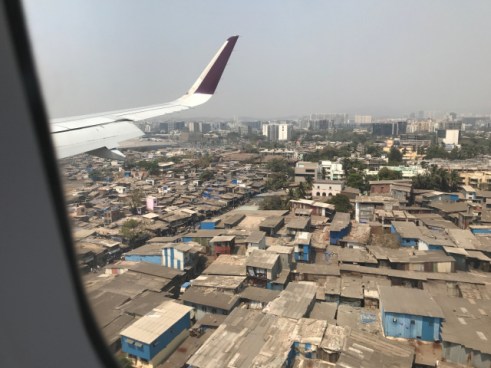
Mumbai is a city laden with class divide. An American photographer, through drone photography, has brought into clear focus the stark divide between the rich and poor in India’s financial capital.

An Urban Jungle

image_542656283772026

Image Clicked by Me

On his official website, Miller describes Mumbai as “an urban jungle, a vertical aerie for the superrich, and a fragile marine ecosystem” where “informal recyclers (Rag Pickers often works as India’s Informal Waste Disposal System)  in Dharavi exist within sight of the National Stock Exchange, traditional fishermen moor their boats in the shadows of skyscrapers in Worli, and leopards prowl the Sanjay Ghandi National Park on the city’s northern flank”.

The images are part of Miller’s ‘Unequal Scenes’ project which he describes as a means to

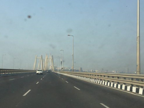
worli

Worli Sea Link Clicked by Me

“provoke a dialogue to address the issues of inequality and disenfranchisement in a constructive and peaceful way”. As part of the project, Miller, has also captured the class divide in Kenya, South Africa, Tanzania, the US and Mexico, over a span of past two years.

A strange mix

Miller’s website describes the area surrounding the Bandra Kurla complex as a mixture of extreme wealth and extreme poverty that houses the consulate generals of several countries, corporate headquarters, and the National Stock Exchange.

Sources:

Economic Times (Mnillers Image Can be Seen here)

Posted in Development, earth, Glimpses of Our Cities, opinions, Population, urban morphology, Urban Studies | Leave a comment

Five Early Urban Hearths

The Urban Systems started early. There were many reasons and factors of early Urban Development.

The early urban development started in some pockets and regions. Here five early hearths of urban development are listed and briefly discussed.

Mesopotamia

The first urban settlements are thought to have started around 3500BC in lower Mesopotamia (Sumer) around the Tigris and Euphrates. First was Ur, which from 2300 BC to 2180BC was the capital city of the Sumerian Kingdom, extending north along the Fertile Crescent, possibly as far as the Mediterranean. In the year 1885BC Ur and the other southern cities were captured by Babylonians.

An Important milestone in development of urban settlements were Zigurrat. Ziggurats were built by many civilizations namely Sumerians, Babylonians,  Elamites,  Akkadians, and Assyrians

Egypt

There is still  an open debate over whether it was diffusion or independent inventions but it is probable that agricultural and other advanced technologies, possibly including city-building, diffused across the Fertile Crescent, then south-west into the Nile valley. By 3500BC a number of the Neolithic farm hamlets along the lower Nile had expanded to ‘overgrown village’ status and formed clusters  of several politically independent units, each containing sizeable irrigation projects like Qanat. The transition from settled agricultural communities to cities taken place around 3300 BC when the lower Nile region was unified by the first pharaoh, Menes. The early Egyptian cities were not as large and as densely populated as those of Mesopotamian cities because of the practice of changing the site of the capital, usually the  largest settlement, with the succession of a new pharaoh limited the growth opportunity of any single city and  the security provided by extensive desert on both sides of the Nile which meant that once the valley was unified politically, Egyptian cities, unlike those of Mesopotamia, did not require elaborate fortifications and garrisoned troops for protection.

The Indus Valley

The Harappa civilisation dates around 2500 BC in the Indus valley in present-day Pakistan. Twin famous capital cities distinguished it, a northern one of Harappa in the Punjab and Mohenjo-Daro, 500 km down the river. The Indus valley towns were planned and the layout of each town was in marked contrast to the organic growth of Mesopotamian cities such as Ur. Both cities were designed on a grid pattern with wide, straight streets forming  rectangular blocks. Socio-spatial segregation was prevalent, with blocks or precincts occupied by a specific group such as potters, weavers, metalworkers and the elite. Each city covered approximately one square mile in area and accommodated around  20,000 people.

The Harappa kingdom was ruled from the twin capitals by a single ‘priest-king’ with  absolute power in his hand . Some evidence of trade with the Sumerian city-states by 2000 BC are found  but the unchanging material culture and still undeciphered written language suggest that, in contrast to the cities of the Nile valley, the Harappa culture and cities emerged on their own. Following a thousand years of stability, the Harappa civilization was phased out.

The Yellow River

The valley of the Huangho ,the Yellow River(Yellow  in colour due to Loess) was the birthplace of the Shang civilisation that came into existence around 1800BC. The most significant feature is that individual cities, such as An-Yang, were linked into a network of agricultural villages; a town wall did not separate an urban subculture from a rural one. This form of ‘urban  region’ is notably  without precedent in the early civilisations of Mesopotamia, the Nile and the Indus.

The layout of the cities shared that of other ancient urban areas of Asia, similar to ones in Egypt and Mexico: a central core with the surrounding area divided into four regions, one for each of the cardinal directions.

Mesoamerica

The earliest cities in the New World appeared around 200 BC—in southern Mexico (Yucatan), Guatemala, Belize and Honduras. Thus Mesoamerican peoples were entering a stage of development equivalent to the Neolithic of the Old World at a time when Mesopotamian cities were  2,000 years old. Of the several civilisations that evolved in Mesoamerica, the Mayan, which flourished between AD 300 and AD 1000, was the most culturally advanced. Cities such as Tikal, Vaxactum and Mayapán were centres of small states ruled by a leader drawn from a priest-hood and organised into a loose confederation. Mesoamerican society was highly stratified, with the elite occupying central city land around the palaces and temples, and the lower classes occupying the periphery of urban settlement. City design was highly advanced.

Source(s):

Urban Geography: A Global Perspective Pacione 2e Pb – Pdf .., https://epdf.tips/urban-geography-a-global-perspective-pacione-2e-pb.html (accessed September 19, 2018).ly

Urban Development in China

Oracle Bones of Shang Time

Posted in Class Notes, earth, Settlements, urban morphology, Urban Studies | 2 Comments