Some History of Egypt and Archaeological Discoveries from Nile Valley

89f0f82221547bf89b3ea06a13344f60
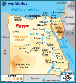
The Greek historian Herodotus called Egypt, “The Gift of the Nile,” and along that life-giving river, the ancient Egyptians built their amazing civilization, one they ruled for three millennia.

The history of Egypt is divided into : Prehistoric, Ancient, Greco-Roman, Medieval, and Modern.

Prehistoric Egypt

Prehistoric Egypt spans the period of earliest human settlement – 3100 BC, or the beginning of the Early Dynastic Period.

Ancient Egypt begins with the early predynastic settlements of the Nile Valley, and continues on until the Roman conquest in 30 BC.

Greco-Roman Egypt

Compared to their Greek predecessors, the Romans displayed a more hostile attitude towards the Egyptians. Christianity took root in Egypt around the mid-1st century, and as it spread through the country over the next couple hundred years temples were closed and pagan rites banned. Anti-pagan riots sparked during the 3rd century AD, and many public and private religious imagery were destroyed.

Medieval Egypt

Upon their settlement, the Arabs introduced Islam and Arabic, and subsequently dominated Egypt for many centuries. The Ottoman Turks gained control of Egypt in 1517, and aside from a brief French incursion (1798-1806), the Ottomans remained until the mid-19th century.

Modern Egypt

Egypt became a British protectorate in 1914, then achieved partial independence in 1922, and full sovereignty in 1945.

The Egyptian Republic was officially declared on June 18, 1953, and General Muhammad Naguib was appointed the first president. Gamal Abdel Nasser, the leader of the 1952 Egyptian Revolution, forced the resignation of Naguib in 1954, and assumed power in 1956.

A Video About History of Egyptian Civilization

Following are some amazing Archaeological Discoveries of Nile Valley:

Tutankhamun’s Tomb

The tomb of Tutankhamun in Egypt’s Valley of the Kings is perhaps the most famous archaeological discovery ever made. Unearthed in 1922 by a team led by Howard Carter, the tomb was filled with fantastic treasures, including Tutankhamun’s death mask, which today is practically an icon.

Rosetta Stone

rosetta

Rosetta Stone

Dating to 196 B.C., the Rosetta Stone holds a decree written by a council of priests that affirms the right of pharaoh Ptolemy V (who was 13 years old at the time) to rule Egypt.


Oxyrhynchus Papyri250px-p-_oxy-_i_29
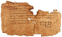
Between 1896 and 1907, archaeologists Bernard Grenfell and Arthur Hunt discovered over 500,000 papyri fragments, dating back around 1,800 years. The investigators found the fragments in the ruins of Oxyrhynchus, a sizable ancient town in southern Egypt that flourished at a time when the Roman Empire controlled Egypt. The town’s arid conditions meant that the papyri used by residents survived nearly 2 millennia.

Pyramid town at Giza
Since 1988, a team of archaeologists from AERA (Ancient Egypt Research Associates) has been excavating a town near the Pyramid of Menkaure, on the Giza Plateau. The pyramid for the pharaoh Menkaure (who reigned from roughly 2490–2472 B.C.) was the last pyramid constructed at Giza, and the people who lived at Giza would have been involved in building the structure.

Tomb KV5

In 1995, excavations at KV5 revealed that the little-studied tomb was actually the largest ever constructed in the Valley of the Kings. Excavations are ongoing and at last report, archaeologists had found 121 corridors and chambers in the tomb; the researchers said they think more than 150 will eventually be found.

The Silver King

In 1939, archaeologist Pierre Montet discovered the tomb of Psusennes I, a pharaoh who ruled Egypt around 3,000 years ago. His burial chamber was located in Tanis, a city on the Nile Delta. The pharaoh was buried in a coffin made of silver and was laid to rest wearing a spectacular gold burial mask, Montet found. (Psusennes I is sometimes called the “Silver King” because of his silver coffin.)

Pyramid-Age papyri
In 2013, a team of archaeologists led by Pierre Tallet and Gregory Marouard announced the discovery of a port built along the Red Sea about 4,500 years ago, during the reign of the pharaoh Khufu. Among the finds are papyri that discuss the building of the Great Pyramid at Giza, the largest pyramid ever constructed.

Source(s) and Link(s) :

Live Science

World Atlas

Early Urban Hearths

Anthropocene

Origin of Agriculture at Fertile Crescent


Posted in Archaeology, Class Notes, earth | 1 Comment

Christopher Browning’s pessimistic take on America’s future

whyevolutionistrue's avatarWhy Evolution Is True

Christopher Browning is an American historian whose expertise is mainly on the Holocaust. His new article in the New York Review of Books is on a related topic: comparing the debilitated state of American politics with what happened during the rise of Nazi Germany. Browning was apparently inspired by the frequent claim that the U.S. is becoming like Hitler’s Germany. Click on the screenshot below to read the free article.


It’s a very good piece that, while drawing some parallels between what happened in the two countries, also doesn’t buy the “Nazi” analogy. A few quotes to tease you:

If the US has someone whom historians will look back on as the gravedigger of American democracy, it is Mitch McConnell. He stoked the hyperpolarization of American politics to make the Obama presidency as dysfunctional and paralyzed as he possibly could. As with parliamentary gridlock in Weimar, congressional gridlock in the…

View original post 511 more words

Posted in earth | Leave a comment

Contours: An Overview

  • Contour –  Contour is an imaginary line on ground joining points of equal or constant elevations. contours are important to draw the topographical maps in which vertical distances are also shown using the contour lines.
  • Contour interval: Vertical distance between any two consecutive contours is known as the contour interval. It depends upon the scale of the map, nature of the ground and availability of the fund  and time.
  • Horizontal equivalent/ horizontal interval:  It is the shortest horizontal distance between the two consecutive contours.
  • Contour Gradient: Imaginary line on the surface of the earth, maintains a constant angle to the horizontal.
Characteristics of the contours:


  1. When contours are drawn closer to each other, it shows a steep slope on the ground and when they are far apart it shows the gentle slope on the ground.
  2.  When they are parallel straight and equivalent they represent a plane surface.
  3. A contour is perpendicular to a line of the steepest slope.
  4. A contour must close itself in the map or must go out of the boundaries of the map.
  5. A set of ring contours with higher values of contour inside and lower values outside represents a hill and if the higher values are outside and lower values inside then it represents a depression like a pond.
  6. When contours cross a ridge they form a V- shape across them. While if they cross a valley they form a u-shape or may a V shape also difference being, the concavity of the contour lines lies towards the lower contours in case of valley while it is convexity lying towards the another lower value in case of contours of a ridge.
  7. Contour lines must close, not necessarily in the limits of the plan.
  8. The horizontal distance between any two contour lines indicates the amount of slope and varies inversely on the amount of slope.
  9. Widely spaced contour indicates flat surface.
  10. Closely situated contour indicates steep slope ground.
    contour showing steep slope terrain
    contour showing steep slope terrain
  11. Equally spaced contour indicates uniform slope.
    contour showing uniform slope terrain
    contour showing uniform slope terrain
  12. Irregular contours indicate uneven surface.
  13. Approximately concentric closed contours with decreasing values towards centre indicate a pond.
    Pond and its contour
    Pond and its contour
  14. Approximately concentric closed contours with increasing values towards centre indicate hills.
    Hill and its contour
    Hill and its contour
  15. Contour lines with U-shape with convexity towards lower ground indicate ridge.
  16. Contour lines with V-shaped with convexity towards higher ground indicate valley.
    contour showing ridge line and valley line
    contour showing ridge line and valley line
  17. Contour lines generally do not meet or intersect each other. If contour lines are meeting in some portion, it shows existence of a vertical  cliff.
    Vertical cliff and its contour
    Vertical cliff and its contour
  18. Contours of different elevations cannot cross each other. If contour lines cross each other, it shows existence of overhanging cliffs or a cave.
    overhanging cliff and its contour
    overhanging cliff and its contour
  19. The steepest slope of terrain at any point on a contour is represented along the normal of the contour at that point.
  20. Contours do not pass through permanent structures such as buildings.
    contour across a permanent structure
    contour across a permanent structure
Uses of Contours:
  1. To study the general character of the tract of the country without visiting the ground. With the knowledge of characteristics of contours, it is easy to visualize whether country is flat, undulating or mountainous.
  2. To decide the sites for engineering works such as reservoirs, canals, roads and railways etc. on the basis of the economy.
  3. To determine the catchment area of the drainage basin and hence capacity of the proposed reservoir.
  4. To compute the earth work required for filling or cutting along the linear alignment of the projects such as canals, roads, etc.
  5. To find out the inter-visibility of the points.
  6. To trace out a contour gradient for road alignments.
  7. To draw longitudinal and cross- sections to ascertain nature of  the ground.

A Helpful Video

Link(s)  and Source(s):
Surveying Vol-I  by Dr. B. C. Punmia
Posted in Class Notes, earth, Geography Practicals/Lab and Statistical Techniques | 1 Comment

China in Crisis? Climate Change, Water Contamination Looming Threats

Guest essay by Eric Worrall China’s environmental and food logistics problems may be far worse than they are letting on. China’s hunger for soybeans is a window into an encroaching environmental crisis 09.25.18 BY JEFF NESBIT How China’s desperate efforts to source soybeans from all over the world is explained by the country’s fear of…

via China in Crisis? Climate Change, Water Contamination Looming Threats — Watts Up With That?

Posted in earth | Leave a comment