Obliquity, inclination and eccentricity of Earth – a model: Part 1

oldbrew's avatarTallbloke's Talkshop

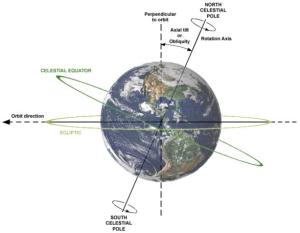
Earth’s Axial Tilt, or Obliquity [Credit: Wikipedia]
First let’s get the approximate target numbers for the model.

‘The inclination of Earth’s orbit varies with respect to the solar system’s invariant plane with a period of roughly 71000 years.
. . .
Taken in conjunction with the 26000-year spin-axis precession, the 71000-year orbit precession causes a 41000-year oscillation in the tilt of the earth’s axis, about plus or minus 1.3 degrees from its average value of 23.3 degrees. This number is not absolutely stable – it depends on the combined positions of all the planets through time.’

Astronomy: precession of Earth (Washington State University)
– – –
Origin of the 100 kyr Glacial Cycle: eccentricity or orbital inclination?

‘Spectral analysis of climate data shows a strong narrow peak with period ~ 100 kyr, attributed by the Milankovitch theory to changes in the eccentricity of the earth’s orbit. The narrowness…

View original post 217 more words

Posted in earth | Leave a comment

Intervening Obstacles in Migration

What Are Intervening Obstacles in Migration?

Intervening obstacle is an environmental or cultural feature that hinders migration Intervening opportunities Intervening opportunities are the nature and number of possible alternative migration destinations which may exist between place A (migration origin) and place B (migration destination).

Intervening obstacles are factors that cause migrants challenges or prevent them from reaching their goal. Examples of intervening obstacles include mountains, forests, deserts, cities and bodies of water. Some of these barriers block the migration of some species, while they do not slow down other specie at all. For example, a large desert may prevent amphibians or insects from completing their migration, while birds fly right over it.

Humans may encounter intervening obstacles during migratory travels as well. Deserts and mountains are particularly difficult for humans to traverse, while forests and cities are easy for humans to cross. Over time, humans often constructed settlements near such challenging features, as a last stop in which travelers could resupply and rest before enduring difficult travels.

Sources:

reference.com

Cultural Geography Blog

Posted in Class Notes | Leave a comment

Fog in Aligarh:Just Clicked

Posted in earth | Leave a comment

Concept of Socio Cultural Regions

If you have heard of places like,Vidharba, Telangana, Bhojpur, Mithila or Awadh, you know about SCR’s . The well you know a SCR it is easier to understand the people, agriculture, traditions Seasons, and buying selling periods. You can also plot them to your needs, say cooking medium: some SCR’s are mustard oil users and some may be groundnut oil users. You can also map hard and soft water. A social planner will have several maps. Maps by food and crop, map by religion, map by monsoon …more the merrier.

Socio cultural regions helps you understand the soul of the place. Often references like “paan belt” or “cow belt” may not sound politically right but they carry a lot of weight. Why Eastern UP is similar to north Bihar? When merging Bhojpur enters Chapra – Siwaan in Bihar and finally converges into Mithila the similarities are bound to happen. Mithila enters into Dwaar- Bang it converges into Bengal. Similarities in language ,food, dress , make up and structures of house are seen.

Source(s):

RuralCampus

Posted in Class Notes | Leave a comment