Gaza mapping initiatives


As the situation continues to deteriorate in Gaza there is a great need for better maps of the crisis situation for use by relief agencies and other people on the ground. One of the initiatives towards disseminating of information is OpenStreetMap (OSM). This project that aims to create a free editable map of the world using GPS devices, aerial photography and other free sources, has started collating information. They are looking for people familiar with Gaza’s street names, features etc. to enhance the bare geometries of the current OSM map. If you know the area or have contacts in the region please get in contact with OSM which is using a wiki to co-ordinate the work.

Several U.N. agencies are also providing information. UN OCHA Occupied Palestinian Territory (UNOCHA oPt) are in addition to the production of humanitarian situation reports supplementing them with overview maps.

UNOSAT also has created and continues to update a Gaza crisis map which depicts the reported attack by Israeli and Hamas forces (25 Dec 2008 – 5 Jan 1008).

The New York Times has also created a map which includes timelines of the latest attacks by Israeli air forces and Hamas.

Source : http://www.alertnet.org

Related : Apartheid Wall in Palestine


Posted in Countries, GIS, map making | 1 Comment

Climate warming means food shortages, study warns

The warming climate is likely to put stress on crops and livestock alike and could cause serious food shortages for half the world’s population, U.S. researchers predicted on Thursday.

The worst effects will be in the regions where the poorest people already live — the tropics and subtropics, the researchers wrote in the journal Science. But temperate regions will see very warm average temperatures, they added.

“In temperate regions, the hottest seasons on record will represent the future norm in many locations,” David Battisti, a University of Washington atmospheric sciences professor, and Rosamond Naylor, director of Food Security and the Environment at California’s Stanford University, wrote in their report.

The two combined direct observations with data from 23 global climate models.

They found a greater than a 90 percent probability that by 2100, growing-season low temperatures in the tropics and subtropics will be higher than the highest current temperatures.

“We are taking the worst of what we’ve seen historically and saying that in the future it is going to be a lot worse unless there is some kind of adaptation,” Naylor said.

There have been some recent tastes of what is to come, such as a heat wave that struck Europe in summer 2003 and resulted in deaths and reduced food production, they said.

Record temperatures hurt key crops including maize and fruit and accelerated crop ripening by 10 to 20 days. Livestock were stressed, the soil was dryer and more water was used in agriculture, they said.

Italy experienced a record drop in maize yields of 36 percent from a year earlier, and in France maize and fodder production fell by 30 percent, fruit harvests declined by 25 percent and wheat harvests declined by 21 percent, they wrote.

“I think what startled me the most is that when we looked at our historic examples there were ways to address the problem within a given year. People could always turn somewhere else to find food,” Naylor said. “But in the future there’s not going to be any place to turn unless we rethink our food supplies.”

Battisti said 3 billion people live in the areas that will be worst affected. The researchers urged investment in development of crop varieties that can withstand higher heat.

“You are talking about hundreds of millions of additional people looking for food because they won’t be able to find it where they find it now,” he said.

“The stresses on global food production from temperature alone are going to be huge, and that doesn’t take into account water supplies stressed by the higher temperatures.”
source

Posted in climate change, food security, Global Warming | 2 Comments

Plate Tectonics

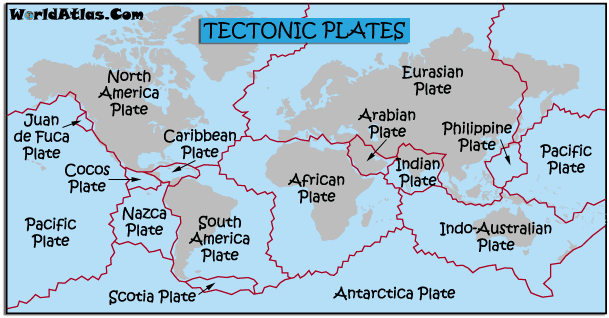
Plate tectonics is one of those topics that you generally skim through in junior high. But what exactly are plates and how are they related to earthquakes? Plate tectonics is a theory that has become a well-accepted reason to explain geological facts about Earth.

The basic idea of plate tectonics is that the Earth is made up of several large, moving pieces of solid rock, on the ocean and on continents. They are plates floating on softer like rock. The plates are in constant motion and sometimes run into one another, this is called a collision, or they slide along, over or under one another. Their motion, and collisions can explain several geological events including earthquakes. It also explains the presence of faults on many continents, where two plates collide, including the San Andreas fault in California.

Under the ocean, the plates explain why there is major seismic energy in the Pacific Ocean and how deep ocean trenches and large fracture zones and rifts in the ocean floor occur. Plates also give reason to associate volcanoes and large mountain belts like the Andes. Plates are the reason mountain belts form, from the pushing of plates and vast spreading and colliding of plate tectonics..

current arrangement of the tectonic plates scattered around the Earth’s crust.

current arrangement of the tectonic plates scattered around the Earth’s crust.

Why are plates so important to understand? How do they contribute to our overall understanding of Earth and seismic motion?

Here is a great article about Plate Tectonics with great illustrations and explanations about faults, environments and locations of plates on Earth. Check it out!

The Pangaea Theory asserts that all of the plates were connected at one point and slowly shifted away from one another. This large continent is called Pangaea. Take the online quiz to test and learn more about this excited theory related to plate tectonics!

Plate Boundaries

There are four types of plate boundaries.

1. Convergent Plate Boundary also known as Destructive Boundary– This is when the continental plate and oceanic plate collide, this causes the oceanic plate to sink into the mantle and destroyed. This can cause explosive volcanoes and violent earthquakes. Example: The Himalayas.

2. Divergent Plate Boundary also known as Constructive Boundary– This boundary happens when two oceanic plates move away from each other. Lava erupts and a new crust is formed on the sea bed. There are underwater volcanoes and gentle earthquakes. Example: The Mid- Atlantic Ridge.

3. Transform Plate Boundary also known as Conservative Boundary – This is when two tectonic plates move in different directions or at different speeds. Plates are locked together by friction while pressure builds up. Finally, the plate breaks along the fault line. There shouldn’t be volcanoes but there will be violent earthquakes. Example: San Andreas Fault.

4. Collision Boundary- This is when two continental plates move together. The two plates are too light to sink into the mantle. Therefore, the plate buckles up and form mountains.

Links:

source

tectonic plate world map

HKIS Future Earth Project


Posted in earth, interior of the Earth, plate tectonics | 5 Comments

Europe shivers, but world is getting hotter

It might feel cold in Europe but the world is getting hotter and global warming remains a danger, the United Nations weather agency WMO said Friday.

“The Secretary-General of the World Meteorological Organization, Michel Jarraud, has stressed that we mustn’t confuse the current weather that we’re seeing with global warming,” WMO spokeswoman Gaelle Sevenier told a news briefing.

Temperatures have plunged to record lows in Germany and heavy snow brought Marseille in normally sunny southern France to a standstill Thursday. Switzerland was shivering under temperatures of below 0 Celsius for the eighth day in a row.

Weather studies since 1850 show an undeniable increase in temperature, Sevenier said.

“Mr Jarraud noted that there can be no doubt that the trend is still toward warming and that the temperature of the surface of the earth has risen by three quarters of a degree since the mid-19th century,” she said.

Most scientists believe global warming is creating extremes of weather bringing death and destruction through hurricanes, floods and drought.

While 2008 was cooler than the previous year, it was the 10th warmest year since records started, Sevenier noted.

She said the cold snap in Europe was due to the “La Nina” phenomenon, in which surface water in parts of the Pacific Ocean is cooler than usual. Through complex meteorological processes that can influence weather over the Atlantic Ocean.

La Nina — which means “little girl” in Spanish — is a periodic phenomenon that alternates with “El Nino” or “little boy,” where water is warmer than usual. Both can affect weather around the world.

source

Posted in climate change, earth, Ecosystem, Environment | 1 Comment