New U.S. Datum Requires Location Corrections

A new datum or geospatial reference system is being introduced in the United States to become the official datum in 2022.  Pam Fromhertz of the NOAA National Geodetic Survey gave an overview of the reasoning behind the new datum, technical details about the change and some practical implications.

A datum is a  reference for position on the surface of the Earth. In surveying, a datum is a reference system for computing or correlating the results of surveys.

Geoid 12BPeople in the geospatial sector in the U.S. are aware of the datums NAD27 and NAD83 which have been the reference points for all surveys performed in the U.S.  NAD83 was defined primarily using terrestrial surveying techniques.  NAD83 has been updated several times since being introduced in 1983, but is based on an elipsoid that is non-geocentric and is tilted slightly. The new datum or North American Terrestrial Reference Frame of 2022 (NATRF2022) is based on gravity which means that “sea level” is now represented by an equipotential gravity surface rather than the Earth’s elipsoid. The new reference frames will rely primarily on Global Navigation Satellite Systems (GNSS) such as the Global Positioning System (GPS) as well as an updated and time-tracked geoid model.  Importantly, the new datum means that Mexico, Canada, and the U.S. will share a common datum.  The gravity-based vertical datum will be accurate at the 2 cm level for much of the U.S. Gravity data is currently being captured across the U.S. and its territories as part of the Grav-D project.

This means that elevations may change by up to a meter and horizontal location by up to 1.5 meters. The actual corrections to elevations and horizontal locations will vary depending on location.

Link(s) and Source(s):

Geospatial Blog

How GPS works

GPS Accuracy and WAAS

Posted in earth, GIS, map making | Leave a comment

The ice edge is a high-risk environment for Arctic industries

RGS-IBG Managing Editor: Academic Publications's avatarGeography Directions

By Siri Veland and Amanda Lynch, Brown University

Veland (copyright) Barrow sea ice Near shore sea ice from Barrow, Alaska June, 2014. (C) Siri Veland

Expectations of receding, thawing and melting of the Arctic have prematurely driven investments and geopolitical negotiation over Arctic marine territories and resources. The elusive mathematics of ice dynamics hamper robust forecasting and modeling, and the incongruent scales at which it is defined pose challenges for planning and coordination. Together, these form a high-risk context for Arctic industries and nations that seek to follow the ice edge northward.

Mapping sea ice
Sea ice behaves unlike other major earth surface processes. Neither purely fluid nor solid, ice does not conform to classical Newtonian physics. Fluids like water and air respond to stress continuously and evenly down to the molecular level. Solids respond to stress by deforming elastically or plastically, or by shattering. Sea ice shares characteristics with each. To represent ice in…

View original post 969 more words

Posted in earth | Leave a comment

Whither the Creative City? The Comeuppance of Richard Florida

Jason Luger's avatarurbanculturalstudies

Talent, Technology, and Tolerance, said Florida (2002), were the pre-conditions for a successful urban economy. Florida’s ‘creative class’ theory, much copied, emulated and critically maligned, delineated urban regions with ‘talent’ (PhDs); ‘technology’ (things like patents granted); and ‘tolerance’ (represented by a rather arbitrary ‘gay index’ of same-sex households in census data).

This combination, according to Florida’s interpretation of his data, indicated urban creative ‘winners’ versus urban ‘losers’: blue collar cities with more traditional economies and traditional worldviews. Creative people want to be around other creative people, wrote Florida, so failing to provide an ideal urban environment for them will result in their ‘flight’ (2005) and the loss of all the benefits of the creative economy. Therefore, to win in the ‘new economy’ (Harvey, 1989), cities need to compete for, and win the affections of, the ‘creative class’. Or so Florida then-believed.

Policymakers were keen to spread the ‘gospel’ of…

View original post 846 more words

Posted in earth | Leave a comment

International Date Line: Line of Demarcation

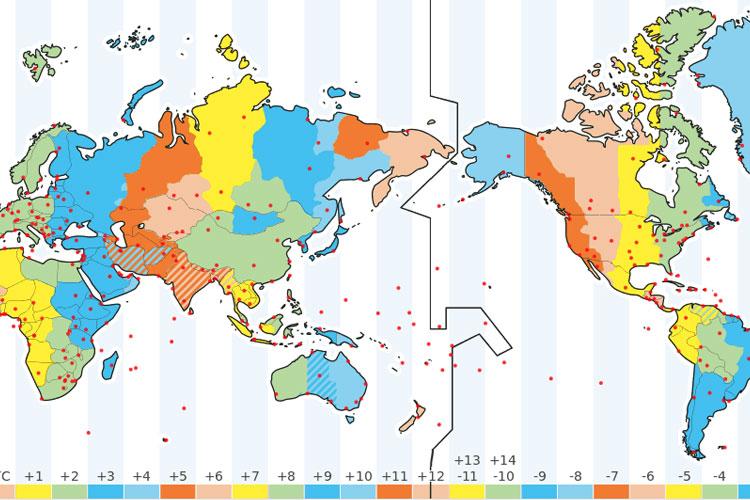
The International Date Line (IDL) is an imaginary line on Earth’s surface defining the boundary between one day and the next.

Time Zone map showing the International Date Line.

The International Date Line (IDL) on the map.

The International Date Line is located halfway around the world from the prime meridian (0° longitude) or about 180° east (or west) of Greenwich, London,, the reference point of time zones. It is also known as the line of demarcation.

IDL Is Not Straight

IDL runs from the North Pole to the South Pole and marks the divide between the Western and Eastern Hemisphere. It is not straight but zigzags to avoid political and country borders and to not cut some countries in half.

When you cross the International Date Line from west to east, you subtract a day, and if you cross the line from east to west, you add a day.

Changing Sides of the Dateline

The dateline is not defined by international law. Countries are free to choose the date and time zone that they want to observe.

In 2011, Samoa changed the time zone from UTC-11 to UTC+13 by shifting the dateline to the west and removing December 30, 2011 from the calendar. They did this to facilitate trade with Australia and New Zealand, and Tokelau followed Samoa for the same reasons.

The 180° meridian was selected as the International Date Line because it mostly runs through the sparsely populated Central Pacific Ocean. It was decided at the International Meridian Conference in 1884 in Washington, D.C. where 26 countries attended.

Lin(s) and Source(s):

Timedate.com

Wikipedia

Posted in Class Notes, earth | Leave a comment