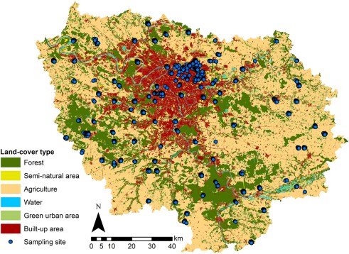
Results of an exciting new study, focusing on the flora of the Paris area have been published. The aim of the study was to better understand the “filters” that allow some species to establish successfully in our cities (while other plant species may fail to establish). These filters can be environmental (cities pose challenges such as high temperatures, dry and impervious soils…) or biological (species that are already there offer stark competition).
The Ile-de-France region, surrounding the city of Paris comprises around 50% of agricultural land, 24% of forests, 16% of built land (including housing, industrial areas, quarries, worksites and transport).
In this paper, researchers used records collected by citizen scientists, part of the Vigie Flore program, with 620 plots (10 m²) surveyed between 2009 and 2017.
They chose to study a unique measure called “species originality“. The idea is that a species is “original” if…
Uncovering the production process of social life in urban spatial settings is one of the essentials in the development of modern urban planning and design (Lefebvre 1991). Spatial structure refers to a set of spatial relationships arising out of the urban form and its underlying interaction between various urban entities (Anas et al. 1998). Urban Fabric is a vital component of urban planning.
Sustainability and Resilience of cities is also points to ponder in this context. There are four pillars of sustainability-Economic, Social, Environmental and Governance.
In the socio-spatial dialectic, social events are argued to be formed through space, to be constrained by space and to be mediated in space (Soja 1989).
Evidence of how the society is reproduced spatially has been found in many ancient cities, where social hierarchies coincide with the spatial organisation of human settlements to a large extent (Lévi-Strauss 1963; Hillier and Hanson 1984).
In contemporary societies, modern technologies have significantly used rapid human mobility, leading to unprecedented urban sprawl over the last century and a half, and thus (re)shaping the urban context with numerous dispersed, hierarchical and interrelated hubs (Castell 2011; Buliung 2011).
The complexity of modern city systems has consequently been issued as a challenge for reclaiming the theoretical significance of urban form in the procedures of contemporary social life and for advancing relevant methodological developments. Modern urban design has been utilised as a primary tool to address the socio-economic issues of cities in history.
In parallel with the ‘social turn’ in modern planning history, in which the focus of modern urban planning was shifted from the individualist invention of ‘ideal’ public spaces to the collaborative planning of functional and democratic spaces (Healy 1997), important theoretical developments in urban design emerged from the 1960s through the 1980s, which have in return contributed to the ‘spatial turn’ in social sciences.
Neo-Marxist urban planning theories have emphasised the importance of the built environment—the ‘second nature’, an artificial nature—in urban production and consumption processes (Lefebvre 1974; Harvey 2010).
The spatial structure of cities has its roots in the recognition of urban centres and the notion of centrality in the urban system. In general, the spatial structure has two principal aspects: the morphological dimension, which refers to the locations, sizes and boundaries of the centres, and the functional dimension, which addresses the significance of the interrelationship between those hierarchical centres (Burger and Meijers 2012). These two principles interact with each other with some level of correlation, but empirical studies at the intra-city scale offer very little to show a robust causal connection between the functional and morphological changes in cities (Hall 2002; Burger and Meijers 2012). In the term’s usage, the normative definitions of these aspects of spatial structure can be reflected in various scenarios.
In geographical research, a series of analytical methods with diverse datasets have been employed to measure these two crucial aspects, which vary from using arbitrarily selected thresholds of urban population densities, employment, or land-uses (e.g., McDonald 1987; Thurstain-Goodwin and Unwin 2000) to adopting network properties based on flows of people (e.g., Thiemann et al. 2010). The focuses of these methods fall mostly on functionality, but they tend to treat the morphological features of urban cases as mere outputs of the statistical performance of the functional attributes of each case. This treatment somewhat simplifies the morphological elements of geographical studies, constraining their significance in meaningfully guiding urban design. This trend is reversed in configurational studies using space syntax, which analyses the -geometrical nearness of urban street networks, whereas the functional dimension is generally accounted for as a dependent product of distributed public spaces (Hillier and Penn 2004).
The space syntax theory proposes that spatial urban structure shapes movement and then movement shapes functions in the city (Hillier 1996). Space syntax representations of spatial structures can efficiently capture as spatial descriptions functional patterns in historic or informal settlements and slums.
Credit: Wikipedia Time for another Tunguska meteor theory.
– – –
When a meteor zooms toward Earth at 45,000 mph with the strength 10-15 megatons of TNT—185 times more energy than the Hiroshima atomic bomb—it could possibly take out the entire planet, says Syfy.
If something like that doesn’t scream total annihilation, it’s hard to say what does, except this time it just missed.
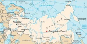
Scorched earth and flattened trees were all that was left of the mysterious object after it passed dangerously close to the Tunguska region of Siberia in 1908.
Theories have ranged from a black hole colliding with Earth to a clash of matter and antimatter to an alien spaceship crash-landing. An eyewitness even swore the sky was being ripped in two. But why no crater? No debris?
Planning is to prepare a Road Map to achieve goals.
The principal phases of an urban planning process are:
Preparatory / exploration phase
Feasibility/planning phase
Formal planning/zoning phase
Design and implementation phase
Operational phase
D.Getz (1987) defines tourism planning as” a process, based on research and evaluation, which seeks to optimize the potential contribution of tourism to human welfare and environmental quality”.
According to Faludi (1973) “Planning is a very important part of the process by which tourism is managed by governments at the national, local and organizational levels”.
If you search online for countries that have had success in planning their tourism, most of them are viewed as great travel destinations. Even to the point that people visit these countries with the guarantee that their travel vlogs will get youtube subscribers. In this day and age, that’s a marker of success.
Tourism development consists of many elements :
developing and managing private-public partnerships,
assessing the competitors to gain competitive advantage and
Ensuring responsible and sustainable development.
Viewing tourism as an interconnected system and a demand-driven sector, assessing private sector investment and international cooperation, tourism clustering and involvement by the Government.
According to Williams cited in Mason (2003);
‘The aim of modern planning is to seek optimal solutions to perceived problems and that it is designed to increase and, hopefully maximise development benefits, which will produce predictable outcomes’.
We should take Planning tourism as an integrated System.Tourism industry is viewed as an inter-related system of demand and supply factors. The demand factors are international and domestic tourist markets and the local resident community who use the tourist facilities and services. The supply factors consist of the tourist attractions and activities as natural and manmade attractions like waterfalls, forests, beaches, monuments, zoos, etc.,
What Planning Should and Should Not Be
Basic Stages in Tourism Development Planning
Tourism development planning is a complex task.There are many variables to consider. There are different levels of tourism planning and policy.
On a basic level, the main stages in tourism development planning include:
Analyses of earlier tourist developments
Evaluation of the of status tourism in the area
Evaluation of the competitors
Formulation of Government Policies
Defining a development strategy and the formation of a programme of action.
The Implications of Planning
Planning enables a range of benefits to all stakeholders involved, for example:
The impacts of tourism can be sorted into seven general categories:
Economic
Environmental
Social and cultural
Crowding and congestion
Services
Taxes
Community attitude
The costs of Tourism Development
There are also some costs which must be considered and planned for, which include:
Costs of implementing tourist facilities can be costly
The environment can be destructed to make room for hotels etc. to be built
Social standards may be undermined e.g. topless women in Dubai
The natural environment may be polluted
Formulating an approach to tourism policy and planning
There are six ‘golden rules’ that should be applied when formulating an approach to tourism planning and policy, as outlined by Inskeep (1991).
Goal Oriented
Clear recognition of tourism’s role in achieving broad national and community goals
Integrative
Incorporating tourism policy and planning into the mainstream of planning for the economy, land use and infrastructure, conservation and environment
Market Driven
Planning for tourism development that trades successfully in a competitive global marketplace
Resource Driven
Developing tourism which builds on the destination’s inherent strengths whilst protecting and enhancing the attributes and experiences of current tourism assets.
Consultative
Incorporating the wider community attitudes, needs and wants to determine what is acceptable to the population
Systematic
Drawing on primary or secondary research to provide conceptual or predictive support for planners including the experiences of other tourism destinations
Why Tourism Planning is Important
Tourism planning really can make or break a destination. If done well, it can ensure the longevity of the tourism industry in the area, take good care of the environment, have positive economic outcomes, and a positive benefit to the community.
If executed badly, tourism development can destroy the very environment or culture that it relies on. It can disrupt local economies, cause inflation and negative effects to local people and businesses. Unfortunately, developing countries tend to suffer the most from negative impacts such as these, largely as a result of limited education and experience in contrast with Western nations.