Fluvial landforms are natural shapes and features formed by the action of rivers and streams. These landforms result from the processes of erosion, transportation, and deposition of sediments by flowing water.
Key fluvial processes include:
Erosion: Water cuts into the riverbed and banks, shaping valleys and creating features such as V-shaped valleys and gorges.
Transportation: Sediments are moved downstream by rolling along the bottom, floating in the water, or dissolving in it.
Deposition: When water flow slows, sediments settle, forming various depositional landforms.
Common fluvial landforms include:
V-shaped valleys: Steep, narrow valleys carved by river erosion in the upper course.
Meanders: Curved bends in the river formed by erosion on outer banks and deposition on inner banks.
Oxbow lakes: U-shaped water bodies formed when meanders are cut off from the main river channel.
Floodplains: Flat, fertile areas on either side of a river formed by deposited sediments during floods.
Deltas: Triangular landforms created at river mouths where sediment is deposited as water enters a slower body of water.
Levees: Raised embankments alongside rivers formed by sediment deposits from floodwaters.
Alluvial fans: Fan-shaped deposits created where rivers flow from steep valleys onto flat plains.
These landforms are continuously reshaped by the shifting balance between erosion and deposition, influenced by water speed, sediment supply, and the landscape’s slope. They play important roles in supporting ecosystems, agriculture, and human settlements.
Engineering projects and geomorphology are closely connected, as understanding landforms, surface processes, and geological characteristics is essential for successful planning, design, and construction of infrastructure. Applied geomorphology informs engineers about terrain stability, soil mechanics, flood risk, landslides, erosion, and material properties at project sites.
Major Applications
Road and Highway Construction: Route selection relies on topography, geomorphic history, and soil strength to avoid unstable areas, erosion-prone sites, and hazardous features such as sinkholes or landslides. Geomorphologists analyze surface deposits, rock types, and landform stability to guide optimal route alignment.
Dam and Bridge Siting: Effective dam and bridge locations require synthesis of geomorphology, lithology, and hydrology, because flood risk, sedimentation, erosion, and foundation stability “depend heavily on local geomorphic context”. For example, karst terrains need careful analysis for voids and solutional features which affect structural safety.
Urban Development: Planning new cities, buildings, or airstrips benefits from landscape analysis; flat, stable surfaces with low flooding and minimal natural hazards are preferred, requiring expert geomorphic mapping and evaluation of soil behavior.
Disaster Prevention and Maintenance: Engineering geomorphology addresses landslide risk, erosion control (e.g., for construction sites), slope stability, and the identification of geohazards, reducing environmental and economic risks in infrastructure projects.
Relationship and Collaboration
Engineering geomorphology uses terrain analysis, ground modeling, and soil/foundation investigations integrated with civil engineering and geotechnics for sustainable infrastructure.
Successful projects require multidisciplinary teams combining geomorphic, geological, and engineering expertise for site investigation, hazard mapping, and resource management.
Geomorphological maps, aerial photointerpretation, and historical landscape studies are critical tools for project planning and risk assessment.
Common Project Examples
Project Type
Geomorphology Role
Road construction
Route selection, landslide, and erosion analysis
Dam building
Site analysis for flood, sediment, and stability
Urban planning
Assessment of stability, flood risk, site suitability
Bridges
Abutment design and foundation stability mapping
Erosion control
Surface analysis for runoff, sediment management
Geomorphology ensures engineering projects are safe, cost-effective, and environmentally sustainable by embedding landform understanding at every stage of development.
Site Suitability Analysis
In the context of geomorphology, site suitability analysis focuses on evaluating the suitability of land or locations for specific uses by systematically assessing geomorphological factors such as landforms, slope, elevation, soil type, erosion risk, and other terrain characteristics. This approach is crucial because the physical landscape and formative geomorphological processes influence stability, drainage, erosion susceptibility, and overall feasibility for development or land use.
Geomorphological Factors in Site Suitability
Key factors considered in geomorphological site suitability analysis include:
Slope and gradient: Steep slopes may limit construction or agriculture due to instability or erosion risk.
Landforms: Different landforms (e.g., plains, hills, valleys) affect drainage and soil characteristics.
Soil type and depth: Reflecting soil fertility, drainage, and mechanical properties.
Erosion and sedimentation potential: Areas vulnerable to erosion might be unsuitable for certain uses.
Elevation and aspect: Affect microclimate conditions and water flow. These criteria are often combined with other environmental and socio-economic data using GIS and multi-criteria decision-making methods to produce suitability maps.
Applications in Geomorphology
Agricultural suitability: Matching crops to landforms and soil types optimized for productivity.
Urban and infrastructure planning: Avoiding geomorphologically risky areas such as landslide-prone or flood-prone zones.
Environmental conservation: Identifying sensitive geomorphic areas for protection.
Water conservation and watershed management: Selecting suitable sites for water harvesting structures and soil conservation based on topographic and geomorphological analysis.
Thus, geomorphology provides essential physical environment criteria that underpin robust, location-specific site suitability assessments, ensuring sustainable and risk-aware decisions.
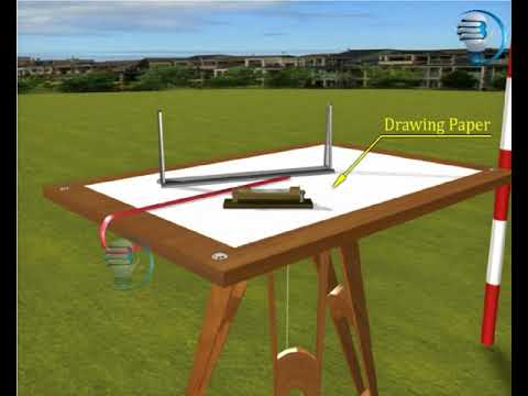
Plane table surveying is a graphical method of surveying where field observations and plotting are done simultaneously on a drawing board called a plane table. The plane table provides a stable, level surface on which a drawing sheet is fixed and maps or plans are directly sketched in the field. The surveyor uses an alidade to sight objects and draw lines on the sheet that correspond to directions of features on the ground. This method allows for real-time creation of scaled drawings by aligning the alidade with ground features and sketching their relative positions accurately.
Key steps in plane table surveying include:
Centering the plane table exactly over a ground point using a plumb bob
Leveling the table horizontally with a spirit level
Orienting the table so directions on the sheet match directions on the ground, often using a compass or by back-sighting known points
Fixing the drawing sheet securely on the table
Taking sightings through the alidade and drawing rays/lines on the sheet corresponding to directions of visible objects or points
The method is especially suitable for small-scale surveys, industrial areas where compass surveys may fail, and for filling in detail between stations fixed by triangulation or traversing methods. There are several methods within plane table surveying including radiation, intersection, traversing, and resection, used for locating points or the plane table itself on the drawing.
This technique is advantageous because it avoids errors from omitting details or misinterpretation by allowing simultaneous observation and plotting. However, accuracy depends on proper setup and careful handling of instruments.
Instruments commonly used in plane table surveying include the plane table (drawing board on tripod), alidade (sighting and drawing rule), spirit level, compass, plumb bob or plumbing fork for centering, and drawing sheets or tracing paper.