
 California enjoys a subtropical and middle latitude location. The climate is much influenced by the state’s latitudinal extent which is a prime determinant of temperatures, wind and humidity. Within the state further climatic variation is influenced by controls that reflect the state’s west coast position and its attitudinal variation.
if the altitude of the entire state is could be reduced to the sea level subtropical environment would be more widespread. Because of latitude temperatures tend to decrease northward from Mexico to Oregon and the growing season becomes shorter. Mountain ranges and maritime influences modify such progression.
California lies between two major worldwide atmospheric circulations – the westerlies and the subtropical high. most of the precipitation comes from westerlies that originate in the North Pacific Ocean and move eastward across North America.California lies to the south of the track followed by many storms: hence precipitation tends to decrease southward. In summer, the subtropical high shifts northwards and consequently western depression move eastward across North America to far north of the state. The entire state tends to be dry in summer.
A large number of people come to California in order to enjoy the benefits of the celebrated climate. It comes as a surprise, therefore, to many newcomers to learn that within the State are to be found a variety of climates, ranging from one extreme to the other. Temperatures have been recorded from minus 45° to 134° F. Annual precipitation at one measuring station has exceeded 161 inches, while other points have gone for more than a year with no measurable rain. A Californian, if he is free to select his living site, may choose almost any kind of climate. This variation in climate results from a number of causes.
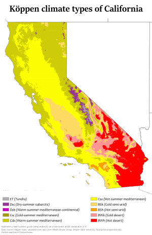
The climate of California varies from hot desert to subarctic’. The variation mainly depends on latitude, elevation, and proximity to the coast. California’s coastal regions, the Sierra Nevada foothills, and much of the Central Valley have a Mediterranean climate, with warm to hot, dry summers and mild, moderately wet winters. The influence of the ocean generally moderates temperature extremes, creating warmer winters and substantially cooler summers in coastal areas.
The cool California Current enhanced by upwelling of cold sub-surface waters, often creates summer fog near the coast, creating a warm-summer Mediterranean climate (Köppen climate classification Csb). Further inland, the climate becomes more continental, with some areas turning semi-arid(Köppen BSk), with colder winters and markedly hotter summers. Low-lying inland valleys, especially the Central Valley, have a hot-summer Mediterranean climate (Köppen Csa), with subtropical temperatures but a well-defined summer dry season and a foggy, rainy season in winter.

Snow on Mountains of California
The temperature gradient between immediate coast and low-lying inland valleys in the south is about 7 °F (4 °C) in winter, the coast being warmer, and in summer roughly 25 °F (14 °C), the interior being warmer. For example, the average daily high in San Francisco in July and August is between 62 and 68 °F (17 and 20 °C),and in Walnut Creek, some 20 miles (32 km) inland, the average daily high in July and August is 90 °F (32 °C): a temperature gain of more than one degree (Fahrenheit) per mile. In the south, the figures are approximately 4 °F and 23 °F (2 °C and 13 °C), respectively. At the coast in Santa Monica, the average high in August is 75 °F (24 °C), while in Burbank, approximately 10 miles (16 km) inland, the average high in August is 95 °F (35 °C): a temperature gain of about two degrees Fahrenheit per mile.

Mediterranean Climate in Santa Barbara
During the cooler winter months (October–March), the Coachella Valley regularly has the warmest winter temperatures out of any place west of the Rocky Mountains. East Los Angeles, the Gateway Cities, and parts of the San Gabriel Valley average the warmest winter high temps (72 °F, 22 °C) in all of the western U.S., and Santa Monica averages the warmest winter lows (52 °F, 11 °C) in all of the western U.S. Palm Springs, a city in the Coachella Valley, averages high/low/mean temperatures of 75 °F/50 °F/63 °F, (24 °C/10 °C/17 °C) respectively during the period of cooler weather from November to April.

Summer in Sierra Nevada at Lake Tahoe
The extreme southwest, around San Diego, has a subtropical semi-arid or steppe climate (Koppen BSh) as winters are drier there.
The southeastern regions have a hot arid climate (Koppen BWh), similar to that of the Sahara Desert. In the northern portion of the Mojave Desert on the east side of the state is Death Valley, which has recorded temperatures among the highest in the world. It is common in the summer for temperatures in the valley to reach 120 °F (49 °C). The highest reliably recorded temperature in the world,134 °F (56.7 °C), was recorded in Death Valley on July 10, 1913. Temperatures of 130 °F (54°C) or higher have been recorded as recently as 2005. The 24-hour average July temperature in Death Valley is 101.8 °F (38.8 °C) (1981–2010 NCDC Normals).

