
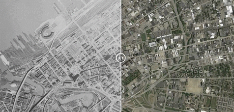
 These superimposed maps of Cleveland now and then are easily used. (University of Oklahoma)
The University of Oklahoma’s Institute for Quality Communities has developed a website that offers superimposed maps of major American cities. The maps cover identical territory in each city, and you can slide a line in the middle to reveal the difference between now and then, then being 50 or 60 years ago at the height of the onset of urban renewal.
It is said that the phenomena of major highways cutting through cities, combined with the elimination of finely grained neighborhood fabric and its replacement with urban renewal and superprojects, has ushered in progress. I think that is debatable. Jane Jacobs, in her Death and Life of Great American Cities, makes a compelling argument that many of the changes were to the detriment of progress, at least in the…
View original post 298 more words


Rasidji, I read the post and the accompanying comments too. I think that the ‘progress’ the planners were talking about is overall progress, what the economists politicians also statisticians may talk about. But I feel that this progress is at the expense of the people living in the area who has been removed to make way for the highways and the accompanying development. That sociologists are commenting on the disturbance of the micro urban fabric or granularity is in itself a comment on the ‘progress’. We in our country too are doing this kind of superimposition on the existing urban areas. The Metro in Delhi is an example. Arguably this is a great boon for commuters but what about those whose houses, businesses, open spaces have been taken over. Can the compensations really compensate for that?
,
LikeLiked by 1 person