
|
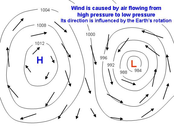
The basic cause of all winds can be traced to contrasts in temperature. These differences When air is heated, its molecules are agitated and their movement accelerated. They tend This effect of the wind “feeling the Earth turn underneath it” is important for very large and long-lived pressure systems. For small, short-lived systems (such as in the cold outflow of a thunderstorm) the wind will flow directly from high pressure to low pressure. The closer the high and low pressure areas are together, the stronger the “pressure gradient”, and the stronger the winds. On weather maps, lines of constant pressure are drawn (as in the example, above) which are called “isobars”. These isobars are usually labeled with their pressure value in millibars (mb). The closer these lines are together, the stronger the wind. The curvature of the isobars is also important to the wind speed. Given the same pressure gradient (isobar spacing), if the isobars are curved anticyclonically (around the high pressure in the above example) the wind will be stronger. If the isobars are curved cyclonically (around the low pressure in the example above) the wind will be weaker. Near the surface of the Earth, friction from the ground slows the wind down. During the day, when convective mixing is stirring up the lower atmosphere, this effect is minimized. At night, however, when convective mixing has stopped, the surface wind can slow considerably, or even stop altogether. Wind can be thought of one way that the atmosphere moves excess heat around. Directly or indirectly, wind forms for the promary purpose of helping to transport excess heat either away from the surface of the Earth, where sunlight causes an excess of energy buildup, or from warm regions (usually the tropics) to cooler regions (usually the higher latitudes). Extratropical cyclones accomplish much of this heat transport outside of the tropics, while in the tropics the trade winds, monsoons, and hurricanes transport much of the heat. |
| Interesting facts: |
| WORLD RECORD WIND SPEED The highest wind speed ever recorded on the surface of the Earth was 231 mph on April 12 1934, atop Mt. Washington, New Hampshire. This high-elevation weather station experienced the winds of an extremely strong jet stream that had descended unusually low in the atmosphere. |
| THE WIND AFFECTS THE EARTH’S ROTATION During the northern hemisphere winter, the stronger westerly winds that build up in the Northern Hemisphere, combined with frictional drag at the Earth’s surface, actually produce a very small, but measurable, increase in the speed of rotation of the Earth.
Global wind pattern All of these winds are part of a global air circulation system that acts to balance temperature and pressure around the world. We already know that different parts of the world receive different amounts of heat from the sun (see sunshine page for more information). This differential heating in turn results in differences in temperature and air pressure around the world – which drives the world’s winds. As equatorial areas are heated most, the air above them warms and rises as it becomes lighter than the surrounding air, causing an area of low pressure. In cooler areas, the air sinks because it is heavier and results in an area of high pressure. Winds will blow as air is squashed out by the sinking cold air and drawn in under the rising warm air. Any difference in temperature like this will always cause a difference in air pressure – and therefore winds will blow. A good expression to remember is that: “winds blow from high to low” (ie: from high pressure to low pressure). So if you know the temperature and pressure in different areas, you will always be able to predict the wind direction. These movements result in a global wind pattern, with air moving between different areas around the world and also at different heights in the atmosphere. Colder air from the poles tends to sink and move towards the equator closer to the surface of the Earth. In contrast, warm air from the equator rises and moves towards the poles high in the atmosphere because it is lighter. This creates cell-like patterns of wind around the world, as seen in the diagram to the left. (Click for larger image). However, winds do not simply blow in straight lines from north to south. Instead, they are bent by the spinning of the Earth: This is called the Coriolis Effect and it bends every wind on Earth, resulting in a distinct pattern of winds around the world. In the mid-latitudes (30-60º north and south of the equator) most winds are westerlies, blowing from the west. Elsewhere they blow mainly from the east; for example the steady winds blowing towards the equator from the subtropics. These are known as trade winds because they were used by sailing ships carrying trading goods around the world. They blow consistently from the NE north of the equator (north easterlies) and from the SE south of the equator (south easterlies). Remember to have a look on the Activities page, where there is a special experiment to demonstrate the Coriolis Effect. To find it, scroll down to the Wind section and click on the Coriolis effect experiment link. Sailing ships have also identified other areas of the world by their unique wind patterns – for example the Doldrums. The Doldrums are an area of low pressure occurring where the trade winds meet along the equator. Winds here are usually calm or very light and so ships would avoid the area because they would only be pushed along very slowly. Another set of famous winds are known as the Roaring Forties. These are very strong westerly winds which blow almost continuously in the southern hemisphere. These fierce winds are found at a latitude of 40º – hence their name! Other named winds can also be found on a smaller scale. These local winds can also have quite an important effect on the weather in different parts of the world, for example the Chinook in North America. Some other examples are given below: The Mistral in France – a cold, north-westerly wind that blows down the Rhone valley. Links and Sources:
Wikipedia |


Pingback: ENERGY FROM WIND | Rashid's Blog
Pingback: Air Fronts | Rashid's Blog
Pingback: Salinity in Oceans | Rashid's Blog
Pingback: Santa Ana Winds | Rashid's Blog
Pingback: Prevailing Winds | Rashid's Blog
Pingback: Water Cycle | Rashid's Blog