
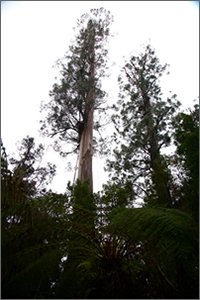
 A true giant among trees—the tallest known hardwood in the world—was discovered and mapped using a combination of lidar and GIS, the same technologies Forestry Tasmania uses on a daily basis for managing forests in Australia’s southern island state of Tasmania. The swamp gum, a eucalyptus, was nicknamed Centurion and measured at 99.6 meters (326.8 feet) in height and 405 centimeters in diameter. Watch the tree being measured in this video.
While tantalizingly short of the 100-meter mark, Centurion is the world’s tallest eucalyptus tree and the tallest flowering plant. Only by few California coast redwood trees are taller. The tallest redwood is 115 meters. Redwoods are softwood trees, which grow taller than hardwoods, however botanists do not classify them as flowering plants.
Centurion was found about 80 kilometers southwest of Hobart, the capital of Tasmania, in a state forest near the Tahune AirWalk.
The use of lidar is attracting growing interest from foresters. The technology was first embraced by engineers, who recognized its ability to map terrain by accurately sensing ground surfaces, buildings, ore stockpiles, and similar features. It was used to enable more efficient quantity surveying, hydrologic mapping, and civil engineering design work based on accurate, high-resolution digital elevation models (DEMs) of the ground.
When lidar is flown over forests and other vegetation, only a portion of the laser pulses penetrate the canopy and reflect off the ground; the remainder is reflected off the trees and shrubs. Engineers have learned how to filter out the vegetation strikes and leave only ground strikes, from which a ground DEM is built. For engineers, each vegetation strike is just a missed opportunity for a ground strike.
Foresters quickly realized that by separating the signals into ground strikes and vegetation strikes, they can build two DEMs: one that maps the ground surface and one that maps the top of the tree canopy. By subtracting one from the other, foresters can get highly accurate maps of tree height-maps long used to monitor growth and assess site quality.


Pingback: LiDAR Finds World's Tallest Eucalyptus Tree | LiDAR News