
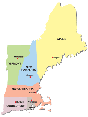
 New England is a geographical region situated in northeastern United States. The region comprises six states of the: Connecticut, Maine, Massachusetts, New Hampshire, Rhode Island, and Vermont.]It is bordered by the state of New York to the west and south, and the Canadian provinces of New Brunswick and Quebec to the northeast and north, respectively. The Atlantic Ocean is to the east and southeast, and Long Island Sound is to the south.
Puritan Separatist Pilgrims from England first settled in the region in 1620, forming the Plymouth Colony, the first successful English settlement in the Americas. Ten years later, more Puritans settled north of Plymouth Colony in Boston, thus forming Massachusetts Bay Colony. Over the next 126 years, people in the region fought in four French and Indian Wars, until the British and their Iroquois allies defeated the French and their Algonquin allies in North America. In 1692, the town of Salem, Massachusetts and surrounding areas experienced one of the most infamous cases of mass hysteria in the history of the Western Hemisphere, the Salem witch trials.
In the late 18th century, political leaders from the New England Colonies known as the Sons of Liberty initiated the resistance to Britain’s efforts to impose new taxes without the consent of the colonists. The Boston Tea Party was a protest to which Britain responded with a series of punitive laws stripping Massachusetts of self-government, which were termed the “Intolerable Acts” by the colonists. The confrontation led to the first battles of the American Revolutionary War in 1775, and the expulsion of the British authorities from the region in spring 1776.
The region played a prominent role in the movement to abolish slavery in the United States, and was the first region of the U.S. transformed by the Industrial Revolution, centered on the Blackstone and Merrimack river valleys.
The physical geography of New England is diverse for such a small area; southeastern New England is covered by a narrow coastal plain, while the western and northern regions are dominated by the rolling hills and worn-down peaks of the northern end of the Appalachian Mountains. With the Atlantic fall line lying so close to the coast, numerous industrial cities were able to take advantage of water power along the numerous rivers, such as the Connecticut River, which bisects the region from north to south.
Each state is principally subdivided into small incorporated municipalities known as towns, which are often governed by town meetings. The only unincorporated areas in the region exist in the sparsely populated northern regions of Vermont, New Hampshire, and Maine. The region is one of the U.S. Census Bureau’s nine regional divisions and the only multi-state region with clear, consistent boundaries. It maintains a strong sense of cultural identity although the terms of this identity are often contrasted, combining Puritanism with liberalism, agrarian life with industry, and isolation with immigration.
Eastern Algonquian peoples
The earliest known inhabitants of New England were American Indians who spoke a variety of the Eastern Algonquian languages.Prominent tribes included the Abenaki, Mi’kmaq, Penobscot, Pequot, Mohegans, Narragansett Indians, Pocumtuck, and Wampanoag.Prior to the arrival of Europeans, the Western Abenakis inhabited New Hampshire, New York, and Vermont, as well as parts of Quebec and western Maine. Their principal town was Norridgewock in present-day Maine.
The Penobscot lived along the Penobscot River in Maine. The Narragansett and smaller tribes under Narragansett sovereignty lived in most of modern-day Rhode Island, west of Narragansett Bay, including Block Island. The Wampanoag occupied southeastern Massachusetts, Rhode Island, and the islands of Martha’s Vineyard and Nantucket. The Pocumtucks lived in Western Massachusetts, and the Mohegan and Pequot tribes in the Connecticut region. The Connecticut River Valley includes parts of Vermont, New Hampshire, Massachusetts, and Connecticut, and linked different indigenous communities culturally, linguistically, and politically.
As early as 1600, French, Dutch, and English traders began exploring the New World, trading metal, glass, and cloth for local beaver pelts.
 Cyclone Vardah is headed towards Chennai and the weather department has issued warning for a very heavy rainfall alert in three districts, Chennai, Kancheepuram and Tiruvallur for the next two days.
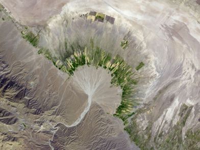 and other particles—alluvium.


