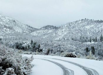
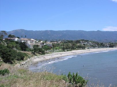
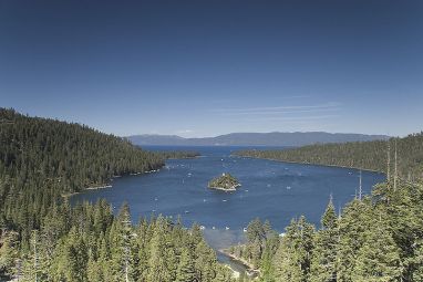
As California is the third largest state, behind Alaska and Texas, and runs almost 1400 kms from north to south. It is not surprising that it offers a contrasting landscape and a diverse topography. California’s general coastline is 840 miles long. Along much of the coast, the Coast Ranges rise from the shore in steep cliffs and terraces. Southern California has many wide, sa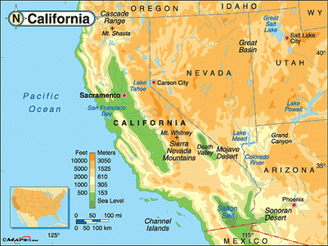 ndy beaches. California’s topography can be characterized by defining eight main regions within the state;
Klamath Mountains: In the northwest corner of the state are the Klamath Mountains. They are comprised of many small forest covered ranges and are higher than the coastal mountains to the south. Many mountains range from about 6,000 to 8,000 feet above sea level. The small ranges are separated by deep canyons.
Klamath Mountains are part of the Pacific mountain system of western North America. The range extends southward for about 250 miles (400 km) from the foothills south of the Willamette Valley in southwestern Oregon, U.S., to the northwestern side of the Central Valley ofCalifornia. The mountains rise to Mount Eddy (9,038 feet [2,755 m]) west of Mount Shasta in California and include numerous subranges. They are deeply dissected by many rivers (especially the Rogue and Klamath), and they contain a headstream of the Sacramento River. Largely within conservation areas, the range, named for the Klamath Indians, embraces parts of the Klamath and several other national forests and includes the Oregon Caves National Monument. Lumbering, dairying, fruit growing, hunting, fishing, and tourism are the main regional economic activities.
Coastal Ranges: The Coastal Ranges in the north reach inland 20 to 30 miles extend from the Klamath Mountains in the north south to Santa Barbara. The Coastal Ranges include many smaller chains of mountain ranges including the Diablo and Santa Cruz Mountains. Some of the valleys separating these ranges are the Napa Valley, north of San Francisco and the Santa Clara and Salinas Valleys to the south. The Coastal Range is home to California’s legendary Redwoods and, less fortunately the San Andreas Fault. The San Andreas Fault enters California from the Pacific Ocean near Port Arena and extends southeast into the state. Earthquakes are caused by movement of the earth’s crust along this fault.
The Coast Ranges of California span 640 km from Del Norteor Humboldt County, California south to Santa Barbara County. The other three coastal California mountain ranges are the Transverse Ranges, Peninsular Ranges and the Klamath Mountains.
Physiographically, they are a section of the larger Pacific Border province, which in turn are part of the larger Pacific Mountain System physiographic division. UNESCO has included the “California Coast Ranges Biosphere Reserve” in its Man and the Biosphere Programme of World Network of Biosphere Reserves since 1983.
The northern end of the California Coast Ranges overlap the southern end of the Klamath Mountains for approximately 80 miles on the west. They extend southward for more than 600 miles to where the coastline turns eastward along the Santa Barbara Channel, around the area of Point Conception. Here the southern end meets the Los Angeles Transverse Ranges, or (Sierras de los Angeles). The rocks themselves that comprise the mountains are of a great variety and widely varying geologic ages. Most of the rocks were formed during the Tertiary,Cretaceous and Jurassic periods. Most were deposited on the sea bottom as sediments, but in many places also had the cracks, crevices and other gaps infused with molten lava or other masses of igneous rock, which were forced in molten condition into the sedimentary rocks. All of the range has been folded and faulted during several periods, with erosion of the softer rock giving much of the current appearance.
The Sierra Nevada: The Sierra Nevada mountain range in the east runs about 430 miles from north to south and forming a giant wall rising to over 14,000 feet. The range varies from around 40 to 70 miles wide. Many peaks in the range reach over 14,000 feet above sea level, with Mt. Whitney, at 14,494 feet, the highest peak in the United States south of Alaska. Mountain streams and glacial action have cut deep valleys into the western part of the Sierras. Yosemite Valley is one of the most spectacular of these valleys. Visit the Sierra Nevadas at the United States Geological Survey.
Sierra Nevada, also called Sierra Nevadas , major mountain range of western North America, running along the eastern edge of the U.S. state ofCalifornia. Its great mass lies between the large Central Valley depression to the west and the Basin and Range Province to the east. Extending more than 250 miles (400 kilometres) northward from the Mojave Desert to the Cascade Range of northern California and Oregon, the Sierra Nevada varies from about 80 miles wide at Lake Tahoe to about 50 miles wide in the south. Its magnificent skyline and spectacular landscapes make it one of the most beautiful physical features of the United States. Biologically, it is home to the largest trees in the world-the giant sequoias. As a recreation centre, its year-round facilities prove a magnet to the inhabitants of the huge urban areas of California, and it has considerable importance as a source of power and water. It was the focus of the celebrated California gold rush.
Central Valley: The Central Valley lies between the Coastal Range and the Sierra Nevada range and is home to the San Joaquin and Sacramento rivers. Sometimes called the Great Valley, the Central Valley is about 450 miles long from points in the northwest to the southeast. A level, broad fertile plain, the Central Valley is the most important farming area west of the Rocky Mountains and comprises about three-fifths of California’s productive farmland.
The Central Valley is a lowland region that extends through central California from the Cascade Mountains in the north to the Tehachapi Mountains in the south. Its 450-mile-long stretch is bounded by the Pacific Coast Range to the west and the Sierra Nevadas to the east. Ranging in width from 30 to 60 miles (78 to 155 kilometers), the Central Valley is divided into two smaller valleys: the Sacramento Valley in the north and San Joaquin Valley in the south. Major cities in this region of the state include Fresno, Modesto, Stockton and the state’s capital, Sacramento. The Central Valley’s fertile soil and extended growing season make it one of the major agricultural regions in the United States.
The Central Valley has a hot Mediterranean climate in the north; the southerly parts of the region are dry and categorized as desert. The Central Valley is prone to greater daily and seasonal temperature ranges than the surrounding mountains or the coast. Precipitation in the Central Valley ranges from more than 20 inches (51 centimeters) a year in the north to roughly 5 inches (13 centimeters) a year in the far south.
Agriculture is the primary industry in much of the Central Valley, with its irrigated valleys accounting for a large share of the fruits and vegetables consumed in the United States. Lettuce, grapes and lemons are among the major crops grown in this region.
Cascade Mountains: The Cascade Mountains extend north from the Sierra Nevada mountain range. They were formed by volcanoes unlike the other mountain ranges in California and support one still-active volcano; Lassen Peak. Lassen is 10,457 feet high and located in the southern Cascades. The Cascade Mountains are also home to Mt. Shasta, once and active volcano. Mt. Shasta rises 14,162 feet above sea level.
Basin and Range Region: The Basin and Range Province contain the southeastern deserts of California. The Basin and Range Region is part of a large region that extends into Nevada, Oregon, and other states.
In the north, much of the area is a lava plateau. This was formed thousands of years ago when the region was flooded with molten lava flowing out of cracks in the earth’s surface.
In the south, a good deal of the area is wasteland and includes the Mojave Desert and the Colorado Desert. Death Valley lies near the California-Nevada border and features some of the most inhospitable territory in the world. Some areas of the Basin and Range Region have been made quite productive, however, due to large irrigation projects that have made farming feasible. Two of these areas are the Imperial and the Coachella Valleys near the California border with Mexico.
The Los Angeles Ranges: The Los Angeles Ranges, between Santa Barbara and San Diego counties, are a group of small mountain ranges that extend east to west. Because of this general east-west direction, the Los Angeles Ranges are sometimes called the Transverse Ranges. Most mountain ranges in California run generally from north to south. Included in the Los Angeles Ranges are the Santa Ynez, Santa Monica, San Gabriel, and San Bernardino mountains. Sometimes the San Jacinto and Santa Ana Mountains are included as part of the Los Angeles Ranges.
The San Diego Ranges: The San Diego Ranges cover most of San Diego county in the southwestern corner of California. These mountains, sometimes called the Peninsular Ranges, include the Agua Tibia, Laguna, and Vallecito mountains and extend southward into the Mexican peninsula known as Baja California.
The general coastline of California is 840 miles long. Much of the coast is characterized by the Coast Ranges rising from the shore in steep cliffs and terraces. In southern California many wide, sandy beaches can be found.
From the peak of Mt. Whitney to Death Valley, California’s topographic diversity is exemplified. Mt. Whitney, the highest point in the 48 contiguous United States, and Death Valley, the lowest point in the United States, lie only 85 miles from each other.
Source(s):
Wikipedia
Maps.com
California Web Portal
Europa


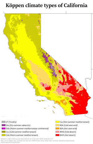 California enjoys a subtropical and middle latitude location. The climate is much influenced by the state’s latitudinal extent which is a prime determinant of temperatures, wind and humidity. Within the state further climatic variation is influenced by controls that reflect the state’s west coast position and its attitudinal variation.