
The size and spacing of rural settlements are influenced by multiple interrelated factors mainly involving physical, agricultural, demographic, and historical aspects.
There are mainly two types of spacing – Spacing amongst the different settlements and spacing inside the settlements. Spacing among settlements is the distance between different communities, while spacing within a settlement is how buildings and open spaces are arranged in one community. Both are affected by factors like the environment, landscape, transport links, available resources, cultural choices, and economic demands.
Factors Affecting the Size of Rural Settlements
- Agricultural Prosperity and Productivity: Fertility of land, the nature of crops grown, crop productivity, and agronomic characteristics are major determinants. Fertile and well-irrigated land supports larger populations.
- Population Size and Density: Larger rural populations lead to increased settlement size, both in terms of population and area.
- Availability of Resources: Access to water and essential resources is vital for supporting and expanding settlement size.
- Topography and Surface Relief: Flat and fertile plains promote larger, more extensive settlements compared to hilly or rugged terrains where settlements are smaller due to constraints on land use.
- Mode of Living and Socio-cultural Factors: Different lifestyles, historical land occupancy patterns, and ethnic compositions influence settlement size.
Factors Influencing Spacing of Rural Settlements
- Agricultural Prosperity: Rural settlement spacing depends largely on agricultural prosperity; denser settlements cluster in agriculturally prosperous areas.
- Surface Relief: The physical landscape and terrain influence how far apart settlements can be. Plains have closer spacing; mountains or uneven terrain results in dispersed settlements.
- Historical Perspective: Settlement history, land use evolution, and tribal distribution affect spacing patterns.
- Population Density and Distribution: Higher rural population density usually results in closer settlement spacing, while sparse populations lead to wider spacing.
- Flood Effects and Soil Fertility: Natural events like flooding and soil fertility variability shape the density and spacing of the settlements.
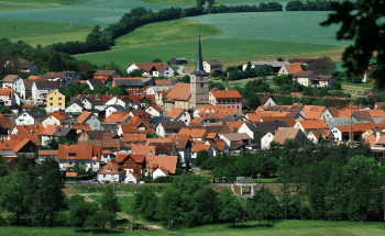
Any settlement in which most of the people are engaged in agriculture, forestry, mining and fishery is known as a rural settlement. It is often called an agricultural workshop. Most of the world’s settlements are rural, and they are stable and permanent. They are of three types:
1. Compact Settlements: A compact settlement is based on farming. These are mostly found in highly productive alluvial plains like the Indo-Gangetic Plains, the Hwang Ho Valley, and the Valley of the Nile. The houses are compact and congested with narrow plains.
The size of these settlements depends on the nature and resources of the surrounding country. They have a high degree of segregation and differentiation between the upper and lower castes. Compact settlements are also found in hunting and fishing communities.
2. Semi-Compact Settlement: Semi-Compact is a transitional phase in the growth of compact settlement. The emergence is because of the difference of semi-arid regions from humid regions and marginal productive land to that of fertile land.Increase in population causes villages to grow in number of houses.
These houses occupy open spaces and lead to semi-compact settlement which ultimately acquires a nucleated settlement.
3. Dispersed Settlement: These are generally found in hills, plateaus and grasslands. These are found in areas where it is essential that the farmer should live on his own land. Overpopulation is one of the reasons for dispersed settlement.

If a part of the population left a village to found a new one, they often found it dispersed rather than a new village. Dispersed settlements are relatively recent in age, like the Steppe grasslands of Kazakhstan.
Patterns of Rural Settlement
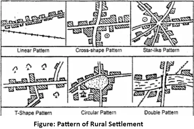
The pattern of settlement is defined as the relationship between one house or building and another. It can be identified by reading and observing a local-scale map. The pattern of settlement deals with compact and semi-compact only, as dispersed has its own shape. The socio-cultural factors like caste structure or a functional need of people have a close bearing on its shape and size. The rural settlements are classified under the following patterns: Rectangular, Linear, Circular, Semicircular, Star-like, Triangular, and Nebular Pattern. The settlement is linear in valleys and mountainous areas, rectangular in fertile plains, circular near the lakes and ponds, triangular at crossroads and in exceptional cases it resembles the nebular form, and on river terraces it is star-type.
a. Rectangular Pattern: This is the most common pattern observed in rural settlements. Rectangular settlements are developed over flat, fertile, alluvial plains and wide valleys. The streets in rectangular settlements are straight and at right angles to each other. The examples of this are villages in Sutlej-Ganga plain, planned settlements of Germany, Malaysia, Israel, France, etc.
b. Linear Pattern: The houses are aligned along the sides of a road, railway line, river, canal or valley. The physical restrictions associated with these sites give rise to the linear pattern. The example of it can be settled along the roads of Ganga-Yamuna plain and in valleys in Alps and Rocky mountains.c. Circular and Semi-circular Pattern: Settlements along seacoasts, around lakes, over mountain-tops and along meandering rivers, develop circular or semi-circular patterns. The population is mostly engaged in fishing, salt production and tourist services like boating, providing boarding and lodging.
d. Star-shaped Pattern: At places where roads converge, radial or star-shaped settlements develop. The new parts of settlement grow along the roads in all directions. The examples of it can be plains of Yangtzekiang, Punjab in India, and parts of Northwest Europe.
e. Triangular Pattern: Points, such as the meeting place of rivers give rise to a triangular pattern of settlements.
f. Nebular Pattern: It is a circular pattern developing all around a centre. This centre could be anything ranging from a temple to a landlord’s house, etc. Rural settlements can be classified based on the size and pattern or shape.
Quantitative Methods and Observations
- Spacing and size show direct proportionality—greater mean distance between villages tends to correspond with larger village size and population.
- Mather’s formula and other mathematical approaches have been used to estimate average spacing and size relative to area and settlement count.
These factors combine to create varying spatial patterns of rural settlements, from clustered dense villages in fertile plains to scattered small hamlets in less hospitable regions.
Link(s) and Source(s):
read here


