Rivers: From Source to Sea

Rivers provide us with food, energy, recreation, transportation routes, and of course water for irrigation and for drinking. But where do they start and where do they end?

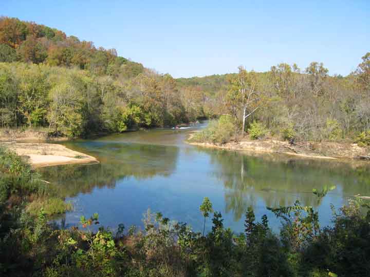
Rivers begin in mountains or hills, where rain water or snowmelt collects and forms tiny streams called gullies. Gullies either grow larger when they collect more water and become streams themselves or meet streams and add to the water already in the stream. When one stream meets another and they merge together, the smaller stream is known as a tributary. The two streams meet at a confluence. It takes many tributary streams to form a river. A river grows larger as it collects water from more tributaries. Streams usually form rivers in the higher elevations of mountains and hills.

The areas of depression between hills or mountains are known as valleys. A river in the mountains or hills will usually have a deep and steep V-shaped valley as the fast moving water cuts away at the rock as it flows downhill. The fast moving river picks up pieces of rock and carries them downstream, breaking them into smaller and smaller pieces of sediment. By carving and moving rocks, running water changes the earth’s surface even more than catastrophic events such as earthquakes or volcanoes.

Leaving the high elevations of the mountains and hills and entering the flat plains, the river slows down. Once the river slows down, the pieces of sediment have a chance to fall to the river bottom and be “deposited”. These rocks and pebbles are worn smooth and get smaller as the water continues flowing.

Most of the sediment deposition occurs in the plains. The wide and flat valley of the plains takes thousands of years to create. Here, the river flows slowly, making S-shaped curves which are known as meanders. When the river floods, the river will spread out over many miles on either side of its banks. During floods, the valley is smoothed and tiny pieces of sediment are deposited, sculpting the valley and making it even smoother and more flat. An example of a very flat and smooth river valley is the Mississippi River valley in the United States.

Eventually, a river flows into another large body of water, such as an ocean, bay, or lake. The transition between river and ocean, bay or lake is known as a delta. Most rivers have a delta, an area where the river divides into many channels and river water mixes with sea or lake water as the river water reaches the end of its journey. A famous example of a delta is where the Nile River meets the Mediterranean Sea in Egypt, called the Nile Delta.

From the mountains to the delta, a river does not just flow – it changes the surface of the earth. It cuts rocks, moves boulders, and deposits sediments, constantly attempting to carve away all of the mountains in its path. The goal of the river is to create a wide, flat valley where it can flow smoothly towards the ocean if it is not captured on the way 🙂 .

source

Posted in Rivers, water | Leave a comment

First Hole in North Pole Ice Drilled by Explorers

A group of Arctic explorers has made the grueling journey to the North Pole and drilled a hole in the ice to take the first ever sample of ocean water at the pole in an effort to better understand the impacts of climate change.The explorers, part of a group called the Catlin Arctic Survey, completed the sampling expedition after failing to last year, reported the Guardian.The team reached the geographic North Pole on May 12 after a 60-day trek across the frigid Arctic ice.

The explorers have been collecting water and marine life samples from beneath the floating sea ice during their expedition in an effort to understand how the acidification of the ocean — caused by the same accumulation of carbon dioxide in the atmosphere that is behind the planet’s warming — is impacting the polar environment. Ocean acidification occurs as the ocean absorbs excess carbon dioxide from the atmosphere, which makes the ocean more acidic and threatens organisms that have shells and skeletons made from certain minerals that dissolve in more acidic conditions, such as corals.

The team drilled their final hole of the mission (and the first hole at the North Pole) manually through the ice at the North Pole, capping off the 483-mile (777-kilometer) trek they have been on since March 14.

read original article here

Posted in climate change | Leave a comment

Flash Floods

Typically, flash floods occur primarily at night and when there is an abundance of atmospheric moisture; in addition, there is usually little, if any, vertical wind shear present. Flash flooding can be produced by large, slow-moving storms or as a result of “train effect” storms (i.e., sequential mature storms that release precipitation over the same area). Train effect storms can be part of multicell cluster or squall line storm systems. Flash-flood waves, moving at incredible speeds, can roll boulders, tear out trees, destroy buildings and bridges, and scour out new channels. Killing walls of water can reach 10–20 ft. On small streams, especially near the headwaters of river basins, water levels may rise quickly in heavy rainstorms.

Flash flooding occurs when a barrier holding back water fails or when water falls too quickly on saturated soil or dry soil that has poor absorption ability. The runoff collects in low-lying areas and rapidly flows downhill. Flash floods most often occur in normally dry areas that have recently received precipitation, but may be seen anywhere downstream from the source of the precipitation, even dozens of miles from the source. In areas on or near volcanoes, flash floods have also occurred after eruptions, when glaciers have been melted by the intense heat. Flash floods mainly occur in the highest mountain ranges of the United States.

Flash floods are slightly different from normal floods. Normal floods involve water rising and overflowing from its normal path. However, flash floods appear quickly and move swiftly across land with little warning. Flash floods occur for a variety of reasons including concentrated rainfall during a slow moving thunderstorm, hurricanes, and tropical storms. The most devastating flash floods are from dam and levee failures. When either structure breaks, an enormous amount of water is suddenly unleashed, destroying everything in its path. The water in a flash flood moves at such a high velocity that it can move boulders, uproot trees, demolish buildings, and destroy bridges. The walls of water in such a flood and be anywhere from ten to twenty feet tall and usually carry a substantial amount of debris.

Sources:

Scienceclarified

Wikipedia

Think Quest

Posted in Uncategorized | 3 Comments

Shrinking of Rivers Tigris and Euphrates leads to Iraq’s Drinking Water Drying Up

Clean drinking water is an increasingly scarce resource for millions of people in Iraq, according to a new report  by the International Committee of the Red Cross.The Tigris and the Euphrates rivers, which supply most of Iraq’s drinking water, are slowly dwindling and in some areas can no longer be used as a reliable source.

Across the country, the shrinking of the rivers is having serious consequences on the functioning of water treatment plants. In underground aquifers, the salt content of the water is increasing. This water is often unfit for human consumption or even for agricultural use.

In many places, the strain is further compounded by a lack of qualified engineers and staff able to maintain and repair water and sanitation facilities.

Many farming communities were hard hit by the drought that struck northern Iraq in 2008. Average rainfall over the past 10 years has been far lower than in previous decades.

In the north, water supply systems fed by springs and shallows aquifers have been depleted and often have less water available to meet demand.

Although rainfall has been better in many places during 2009 and 2010, low water levels continue to affect agriculture production, meaning Iraq needs to import more rice and wheat.

read the article here

Posted in Countries, Ecosystem, water | 1 Comment