

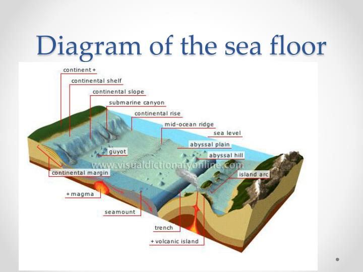
The study of landforms is the science of topography. When we speak of the topography of the ocean floor, we mean the various shapes that the bottom of the ocean can take. We tend to picture the ocean floor as being as flat and sandy as the beaches with which we are familiar. Fortunately, the ocean floor isn’t quite that simple, predictable, or boring. Though the bottom of the ocean is hidden from our sight by vast quantities of water, it’s anything BUT boring, flat and featureless. Maps like the one above are giving us increasingly detailed views of the ocean floor. As our technological expertise increases, so does our ability to visualise these distant landscapes. We find basically that the ocean floor has all the same shapes, bumps, mountains, valleys, plateaus and such that we are more familiar with on the surface. When you consider that three quarters of our planet’s surface is covered by ocean water, you soon realise that there’s more land “down there” than we have “up here”. It really isn’t all that different from the land on which you and I live.
As the continent ends and we approach the ocean, we see some drastic changes in the Earth’s geology. This transitional area is known as the CONTINENTAL MARGIN. This area includes both the continental shelf and the continental slope. Even the very rock with which the Earth is made changes. The heavy and thick continental granite gives way to a thinner layer of basalt. As you first proceed into the water, you are standing on the continental shelf. This gradually sloping and shallow area generally contains water that is only a couple of hundred feet deep. The NERETIC ZONE is located here. The width of the continental shelf varies greatly depending on location. The width of the continental shelf varies greatly depending on location. Off the coast of Maine, the shelf extends for about 200 kilometers. In other places, like the Atlantic coast of Florida, the continental shelf is very narrow, somewhere in the 1 -2 kilometer range, or less. As you pass the edge of the continental shelf, you will notice that the floor begins a steep descent. This steeply sloping portion is called the
CONTINENTAL SLOPE. The continental slope marks the boundary between the continental type granite crust and the oceanic basaltic crust. Occasionally, you will observe deep “V” -shaped valleys cut into the hard rock of the continental slope. These are called SUBMARINE CANYONS. Geologists speculate that these canyons are formed due to seismic activity, or perhaps eroded into the rock of the slope by powerful ocean currents.
As the slope begins to level out, you approach the ocean basin. The ocean basin also has some interesting topography to examine. Perhaps the most unusual are the ABYSSAL PLAINS. These are large, flat areas on the ocean floor covered with a thick layer of sediment and decomposing organic “ooze”. Abyssal plains are larger in the Atlantic ocean than they are in the Pacific. The reason for this is that many of the world’s major sediment carrying rivers empty into the Atlantic and Indian Oceans. Also, the Pacific ocean is ringed with large trenches which act as traps for the sediments. Large, undersea volcanoes called SEAMOUNTS occasionally rise from the depths. Sometimes the peaks of these giant underwater volcanoes reach to the surface to form volcanic islands. The island of Hawaii is really the top of a seamount that is over 9,600 meters tall! The tallest mountain on Earth!
About 20,000 years ago, during the last Ice Age, much of the ocean’s water was frozen in the form of vast glaciers. As a result, the ocean’s level was lower than it is today. Much of the Earth’s freshwater was tied up in the massive ice pack covering large parts of the continents. As a result, there was less water involved in the Hydrologic Cycle, so the ocean’s were lower, much lower, to the tune of about 300 feet less than today. Wave action neatly eroded the tops of some existing seamounts, causing them to eventually have flat tops. When the large ice sheets melted, the water returned to the ocean, and the ocean levels rose. Today we see many GUYOTS present around 300 feet below the ocean’s surface. These flat-topped seamounts are constant reminders of the Earth’s diverse history, and its ever-changing present and future.
OCEAN TRENCHES are found along the edge of ocean basins. These trenches contain the deepest parts of the ocean, and therefore, the deepest parts of this wonderful world. The deepest spot on Earth is located in the western Pacific, near Guam in the Mariana Trench. The exact location is called CHALLENGER DEEP and the water there is 11,033 meters deep! That’s nearly seven miles of water!!! Seven miles is a long way, particularly when we remember that sunlight can penetrate maybe only 1500 feet or so down. Who knows what mysteries lie unsolved this deep beneath the waves. What discoveries await from this ecosystem so far removed from the warm yellow light of our sun? At one time, people would have told you that nothing could possibly exist at these depths. Yet, we’ve seen entire ecosystems living in the deepest parts of the ocean, functioning independently of the sun’s light, upon which we surface creatures depend so much. The most exciting times lie ahead of us in our exploration of the oceans of this wonderful world!
Image Link: https://image1.slideserve.com/2365377/diagram-of-the-sea-floor-n.jpg


There is a movement to turn a portion of the Mariana Trench into a protected area. You should check it out.
LikeLike
this website needs more pictures of the articles meaning.
LikeLike
You are completely right. It would definitely help me understand.
LikeLike
Thanks a lot! This is very helpful to my research
LikeLike
thnx 4 the info. it helped alot!!!!!!
LikeLike
@Poky,Paulina
Thanks,Keep Visiting
LikeLike
i think u need to update this a little it still is cool though
LikeLike
it is a good website to find enough information for school projects d stuff der could be more
LikeLike
Thanks…Hi
LikeLike
It does seem that everybody is into this kind of stuff lately. Don’t really understand it though, but thanks for trying to explain it. Appreciate you shedding light into this matter. Keep it up
LikeLike
thanks a lot….
LikeLike
you need to have good pictures for better explaination…………
LikeLike
its really nice to see this site,all the best rashid sb
LikeLike
I need diagram of the ocean
LikeLike
Thank you so much Mr Rashid.. May i have your permission too use some of the material for teaching purpose?
LikeLike
@Sudeshna. Of-Course You can use any material on this blog for teaching. This serves the main purpose of this blog.
Keep Visiting
LikeLike
add new findings also.
LikeLike
All is well
LikeLike
Pingback: Ocean Conveyor Belt
nice
LikeLike
Pingback: Dynamics of Energy Flow and Climate Change | Rashid's Blog
Nice
LikeLike
Am glad to know that the ocean it’s around three times more than the continent
LikeLike
very cool website helped alot
LikeLike