
“They are never spoken about when Palestine is mentioned. Yet they are among the pioneers of the struggle against the Israeli occupation. Here is the…
Afro-Palestinians of Jeursalem

“They are never spoken about when Palestine is mentioned. Yet they are among the pioneers of the struggle against the Israeli occupation. Here is the…
Afro-Palestinians of Jeursalem
Petroleum accumulates in specific geological settings where the right combination of source rock, reservoir rock, caprock, and structural or stratigraphic traps are present. The most likely geology for petroleum bearing includes sedimentary basins with particular rock types and structures.
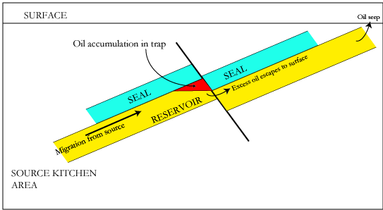


Fault Trap
Sedimentary basins with organic-rich source rocks, porous and permeable reservoir rocks, effective caprocks, and robust trapping mechanisms are the ideal geological settings for petroleum accumulation and extraction.
read more here
The principle of uniformitarianism in geology is the concept that the natural laws and processes operating today have always operated in the same way in the past, and these processes are sufficient to explain all geological changes observed in Earth’s history. It emphasizes that the present is the key to the past, meaning that by understanding current geological processes, one can interpret past geological events and formations. This principle was first proposed by James Hutton in the late 18th century and later popularized by Charles Lyell.
Uniformitarianism involves several key ideas:
The doctrine serves as a foundation for modern geology by allowing scientists to use present-day observations to infer past geological conditions, rejecting supernatural or catastrophic explanations dominant before its introduction.
Uniformitarianism propounds that the Earth’s features are shaped by continuous and consistent processes over immense periods, making the present the key to understanding the geological past.

How do we categorize water quality swales that are dry for most of the time?
Dry Swales

